Your cart is currently empty!
2024 was the warmest year for Minnesota on record
The year 2024 was marked by extreme weather events, with a combination of persistent drought, record-breaking floods, excessive rainfall, and some of the warmest temperatures ever recorded across the state.
Here’s a look back at what 2024 brought us in terms of weather.
January
The month of January was overall very cloudy, with 17 days of reported cloudy skies. It ended up being the cloudiest January on record since 1963. The month ended with a warm spell, as the final week saw daily mean temperatures averaging 18 to 25 degrees above normal across the state. A record high temperature of 55 degrees was reported at MSP airport on Jan. 31.
Mid-January was the start of a record 24 consecutive days with temperatures above freezing, ending on Feb. 14. This streak surpassed the previous record of 21 days set during the winter of 2006-2007.
MPR News helps you turn down the noise and build shared understanding. Turn up your support for this public resource and keep trusted journalism accessible to all.
Between the record high temperature and record thaw, the month was almost 6 degrees above the average monthly high of 23.6 degrees.

January 2024 average temperature departures
Minnesota Department of Natural Resources
February
The month of February brought a Valentine’s Day snowstorm, which dumped 6.9 inches of snow, making up nearly all of the month’s total snowfall of 7.0 inches.
A warm record event brought a new record of 65 degrees at the MSP airport on Feb. 26-27. This event produced the highest February temperatures on record at over 30 Minnesota climate stations. Daily high temperature records were set at International Falls (53 F), Rochester (69 F), St. Cloud (58 F), and the Twin Cities (65 F). The month ended almost 13 degrees above average.
The warmer weather in February caused The Art Shanty Projects to close down after their opening weekend. They successfully opened the art exhibit on Lake Harriet in late January, but the following week, temperatures trended up, hitting a record 50 degrees on Monday and continuing to break records throughout the week.
That 13 inches of ice quickly diminished to 10 — the Shanty’s established limit. Organizers had to cancel weekends two, three and four, citing “climate chaos.”

Sunny skies and no snow cover at the Weather Lab on Feb. 1.
NOAA
March
March brought a wide range of weather conditions, from breezy winds to record-breaking temperatures, as well as enough snow and rain to double seasonal totals in some areas. The month kicked off with shattered high temperature records, starting with a tie for the record high of 59 degrees on March 1.
The following day, March 2, broke the previous record with a high of 63 degrees, and the warmest day came on March 3, when temperatures soared into the 70s. MSP Airport recorded 74 degrees, marking the earliest and warmest reading for the month. Additionally, March 3 saw a wind gust of 56 mph. March ended up 4 degrees above normal.
A powerful winter storm blanketed the state with heavy snow, rain, slush, thunderstorms, and strong winds. This slow-moving storm impacted the region with multiple rounds of precipitation over several days.
What made this storm particularly unique was the combination of heavy snow and heavy rain. The Twin Cities recorded 15.2 inches of snow and 2.51 inches of rain during the event.

Observed snowfall March 24th through March 28th
National Weather Service

Observed precipitation March 24th through March 28th
National Weather Service
April and May
The late season March snowstorm kicked off the start to a very wet period. The month of April brought 4.19 inches of rain, and fairly seasonal temperatures. May recorded 5.81 inches of rain, and 3 degrees above average.
We ended with a very wet and warm meteorological Spring (March, April, and May).

Monthly precipitation March-May 2024
Minnesota Department of Natural Resources
June
June was an exceptionally wet month, with precipitation reported for 18 days. A heavy rain event early in the month brought 1.5 inches of rain, but the wettest period was from June 15-22, when the Twin Cities received over 4 inches of rain.
In total, 7.27 inches were recorded, making the month the fourth wettest June and the fifth wettest month overall on record in Minnesota. Some other impressive reports included:

Total precipitation June 2024
Minnesota Department of Natural Resources

Total precipitation from June 15th through June 24th
National Weather Service
This prolonged period of heavy rainfall caused severe flooding in parts of northeastern and southern Minnesota. Several streams and rivers experienced record or near-record flooding, with the most notable incident being the Rapidan Dam on the Blue Earth River, which gained national attention.

What was once the site of the Rapidan Dam Store and the Hruska Family Home is now gone as the flooding of the Blue Earth River changed the riverbed dramatically, with the Rapidan Dam still standing on July 2.
Hannah Yang | MPR News
July
The pattern of heavy rainfall persisted into July, with rain occurring on 18 days, each registering at least a trace of precipitation. The Twin Cities received a total of 5.61 inches of rain during this period.
July 14 marked the first 90-degree temperature of the season, and the month went on to produce a total of five days with temperatures reaching 90 degrees or higher. Overall the temperatures were seasonal for the month of July.
On July 31, a powerful storm brought giant hail, heavy rain, and strong winds, producing one of the largest hailstones recorded in the state in at least 38 years. A massive hailstone, measuring approximately 6 inches in diameter, fell in Chokio, Minn. Here is another image showing the large hail that resulted from that storm.

Very large hail — reports of grapefruit size or larger — fell across parts of Big Stone and Stevens counties in western Minnesota on July 31.
August
August brought a double header of severe weather to the state. During the Minnesota State Fair on Aug. 26-27, two waves of severe weather hit central and southern Minnesota, knocking down trees and producing over 100,000 power outages. These storms late in the month contributed to the final total of 5.37 inches of rain.

The Minnesota State Fair grounds experienced damage after storms Aug. 26 that caused the fair to delay it’s opening on Aug. 27.
Regina Medina | MPR News
Preceding these storms was a very humid and warm air mass that settled over much of Minnesota. Dew point temperatures had climbed into the mid to upper 70s, with some areas even reporting rare low 80s.

Late August dew points.
NOAA via Tropical Tidbits
September
The atmospheric spigot seemed to just completely shut off come September. We experienced a dry spell of 50 days from Sept. 1 until late October, leading to widespread drought conditions. Measurable precipitation wasn’t recorded until Oct. 24.
It was the warmest and driest September on record. The average temperature for September was 70.4 degrees, surpassing the previous record of 69.1 degrees set in 2023. Additionally, a record-low monthly precipitation of just 0.06 inches was recorded, breaking the previous record of 0.24 inches set in 2022.

Total change on the US Drought Monitor over an 8-week period Sept. 3 through Oct. 29.
National Drought Mitigation Center
October
A warm spell in October brought temperatures in the 70s and 80s, with several breaking records. On Oct. 21, the high reached 85 degrees, and on Oct. 28, a high of 75 degrees set a new record.
Similarly, Oct. 29 saw a record-breaking 80-degree temperature, marking the latest 80-degree reading since 1950. Overall the month ended up almost 8 degrees above the average monthly temperature.
Two days after record-breaking warmth, another Halloween snowfall took place, with MSP Airport reporting 1.26 inches of liquid precipitation and 0.2 inches of snow. The liquid amount surpassed the previous record of 0.85 inches set in 1991.
November
The 2024 meteorological autumn in Minnesota, spanning from September to November, was the warmest on record in the state’s 130-year history.

Minnesota average daily autumn temperatures 1895-2024
Minnesota Department of Natural Resources
November saw 1.94 inches of liquid precipitation, with the majority of that falling on Nov. 18, when 0.86 inches were recorded. This amount broke the previous record of 0.82 inches set in 1981. The average monthly temperature was 38.5 degrees, which was 4 degrees above the average.
December
The final month of the year brought a warm spell of 9 consecutive days above 32 degrees. A notable high of 52 degrees was recorded on Dec. 7, though it fell short of the record of 54 degrees.
December saw 0.62 inches of rain on the 27th, followed by a record-tying temperature of 47 degrees on Dec. 28. Preliminary data indicates that December was nearly 3 degrees warmer than average.
Warmest year on record
Temperature data shows that 2024 has become the warmest year on record in the Twin Cities since 1873 at 50.9 degrees, and possibly across the entire state once the final numbers are analyzed.
The previous records for the Twin Cities were 2012 and 1931 with an average temperature of 50.8 degrees.

2024 warmest year on record
Minnesota Department of Natural Resources
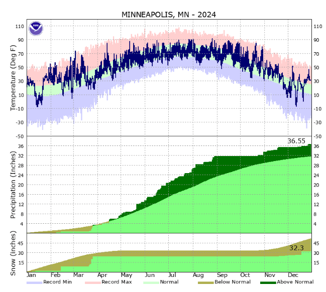
It wasn’t a record year for precipitation, despite the possibility after a wet spring and summer. We finished the year with 36.55 inches of precipitation, earning the 13th spot in the rankings.

Top yearly precipitation
Minnesota Department of Natural Resources

2024 Twin Cites-temperature, precipitation and snow chart
National Weather Service
In a record-breaking turn of events, 2024 has been officially declared the warmest year on record for Minnesota. With temperatures soaring higher than ever before, residents across the state experienced unprecedented heat waves and prolonged periods of scorching weather.
The effects of this extreme heat were felt far and wide, from agricultural impacts to public health concerns. Crops struggled to survive in the intense conditions, leading to reduced yields and potential food shortages. Meanwhile, residents were urged to stay indoors and stay hydrated to avoid heat-related illnesses.
As climate change continues to accelerate, the likelihood of more record-breaking years like 2024 becomes increasingly probable. It is more important than ever for individuals, communities, and governments to take action to mitigate the effects of global warming and work towards a more sustainable future for all.
Tags:
- Minnesota weather
- Record breaking temperatures in Minnesota
- Climate change impact in Minnesota
- Minnesota temperature trends
- Warmest year in Minnesota history
- Minnesota climate data
- Minnesota weather patterns
- Minnesota heatwave
- Minnesota climate statistics
- Minnesota climate report
#warmest #year #Minnesota #record

Leave a Reply