Strong Showers and Breezy Weather Lie Ahead Sunday
Strong Showers and Breezy Weather Lie Ahead Sunday

Updated: 6:47 PM EST Dec 28, 2024
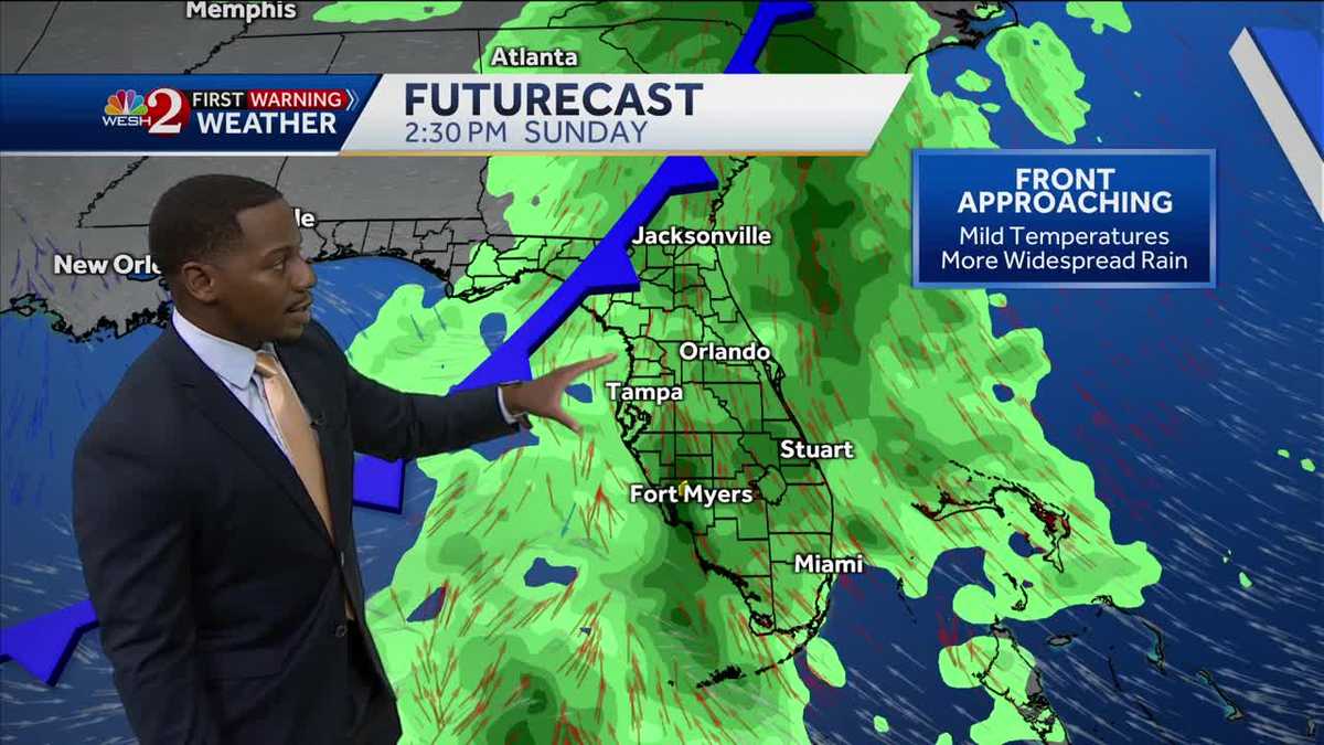
P.M. ALL RIGHT. LET’S CHECK IN NOW WITH MARQUISE MEDA. WHEN WE TALK ABOUT THIS LAUNCH. BECAUSE MARQUISE YOU SAY IT’S GOING TO BE A DOWNPOUR TOMORROW, ARE WE GOOD TO GO FOR A LAUNCH? I THINK THIS GUY IS PRETTY HAPPY ABOUT IT. SO THE LAUNCH IS BASICALLY HEADING INTO THE MORNING TOMORROW, RIGHT? SO WE’LL GET THOSE SHOWERS HERE IN CENTRAL FLORIDA IN THE AFTERNOON. SO BY 12 MIDNIGHT, JUST AFTER TONIGHT INTO TOMORROW MORNING, OVERNIGHT IS WHAT WE’LL CALL IT. I THINK WE’LL BE IN FAIR SHAPE, JUST A LITTLE CLOUDY, A LITTLE BIT HUMID AND JUST A LITTLE BIT BREEZY. DANCING IN THE BREEZE. RIGHT NOW WE HAVE A FAMILIAR FRIEND AT PORT CANAVERAL. THIS IS OUR RUSTY’S AT THE SEA TOWER. CAM. MAYBE HE’S DOING A LITTLE RAIN DANCE, BECAUSE THAT IS WHAT IS HEADING OUR DIRECTION TOMORROW. OUT ACROSS OUR TOWER CAM. RIGHT NOW, CLOUDY SKIES ARE BACK IN THE PICTURE, BUT TEMPERATURES ARE TRENDING FAIRLY WARM. WE’RE BACK IN THE MID AND UPPER 70S IN CENTRAL FLORIDA TODAY WITH A FEW RAIN SHOWERS HERE AND THERE, BUT A MUCH STRONGER CHANCE FOR RAIN THAT SLIDES INTO THE PICTURE TOMORROW, ESPECIALLY ACROSS OUR NORTHERNMOST COMMUNITIES WHERE WE COULD RUN THE RISK FOR SEVERE WEATHER BY NEW YEAR’S, THOUGH, WE’LL BE DRYING OUT AND COOLING DOWN AS TEMPERATURES ON NEW YEAR’S DAY SHOULD FALL BACK INTO THE 60S. RIGHT NOW, ONLY ONE OF US IN THE 60S, THAT’S WINTER HAVEN, 69 DEGREES LOW TO MID 70S. EVERYWHERE ELSE HERE IN CENTRAL FLORIDA, AS WE WERE TRENDING WARM ONCE AGAIN ON THE LAST WEEKEND OF THE YEAR. BUT BREWING ACROSS EASTERN TEXAS, CUTTING INTO LOUISIANA, PARTS OF MISSISSIPPI, ARKANSAS, EVEN WE DO HAVE SOME STRONGER SHOWERS AND STORMS. IN FACT, TORNADO WATCHES ARE IN PLACE ACROSS TEXAS, LOUISIANA, AND MISSISSIPPI CURRENTLY. KEEP IN MIND, DECEMBER IS TYPICALLY ONE OF OUR DRIER YEARS ACROSS THE SOUTHEAST. NEVERTHELESS, THOUGH, THAT LOW PRESSURE SYSTEM IS PACKING A SIGNIFICANT PUNCH BY THE TIME IT GETS HERE, THOUGH, IT MAY LOSE SOME OF THAT ENERGY, WHICH IS GOOD NEWS FOR US HERE IN CENTRAL FLORIDA TO OUR SOUTH ACROSS I-95, AS YOU HEAD TOWARDS FELLSMERE AND VERO BEACH, WE DO HAVE SOME STRONGER SHOWERS. CURRENTLY, THESE ARE RISING TOWARD THE NORTH. COULD BE IN MICCO IN THE NEXT HALF AN HOUR. THE REST OF THE SHOWERS THAT WE’VE SEEN ON RADAR THOUGH, ACROSS SUMTER, ALSO POLK COUNTY, THOSE ARE FADING AS WE SPEAK. SO YOUR NEXT 12 HOURS LOOK LIKE THIS. ONLY A 10% CHANCE FOR RAIN OVERNIGHT. WE’LL SEE TEMPERATURES DIP DOWN INTO THE MID AND UPPER 60S ON WHAT’S A WARM EVENING FOR US WITH A FEW SHOWERS SPRINKLED IN. ULTIMATELY WILL BE IN AND OUT OF THE CLOUDS OVERNIGHT, AND THAT BETTER CHANCE FOR RAIN THAT RETURNS TOMORROW IN THE AFTERNOON. SO WE SHOULD RANGE BETWEEN 64 AND 68 DEGREES WITH MOSTLY CLOUDY SKIES AND THE OCCASIONAL SHOWER AROUND TOMORROW MORNING. I RECOMMEND COMFY CLOTHES. WE’RE BACK IN THE UPPER 60S TO START YOU OFF AS WE STAY HUMID, BUT IN THE AFTERNOON, STORMS ARE CERTAINLY GROWING. HERE’S WHAT WE’RE DEALING WITH. IT’S THIS AREA OF LOW PRESSURE DRIVING A COLD FRONT ACROSS THE PENINSULA IN WHICH SUNDAY AFTERNOON YOU CAN SEE SOME STRAY SHOWERS. BUT THE BULK OF THE PRECIPITATION, THAT IS. EXCUSE ME. IN THE MORNING YOU CAN SEE SOME STRAY SHOWERS. THE BULK IS DURING THE AFTERNOON AND ACROSS THE EVENING, BUT A LOT OF DRY AIR LIES ON THE BACKSIDE OF THIS FRONT. SO TIMING IT ALL OUT. NOW ON FUTURECAST. HERE WE ARE AT 1130. YOU’LL SEE THE SHOWERS INSIDE OF THE METRO. THESE CONTINUE TO PUSH TOWARDS THE EAST, BUT EVEN AT ONE TWO, 3:00 WE COULD STILL HAVE SOME STRONGER SHOWERS AND BREEZY CONDITIONS TO OUR NORTH. WIND SPEEDS COULD POSSIBLY SURGE UP TO 40MPH IN PARTS OF MARION AND ALSO FLAGLER COUNTY. AND THAT’S WHERE WE HAVE THAT SEVERE WEATHER RISK. AND AS FAR AS RAINFALL ACCUMULATION GOES, LOOKS LIKE THE GFS IS PUSHING MORE RAIN OUT TOWARDS THE EAST. COULD SEE ABOUT HALF AN INCH TO AN INCH BEFORE THE YEAR IS SAID AND DONE. AND THEN WE DO SEE DRIER AIR ON THE BACK END OF THIS FRONT. WARMER TEMPERATURES, A LITTLE BIT OF MOISTURE TUESDAY, BUT WE ARE SIGNIFICANTLY DRY AND COOL ON WEDNESDAY, COURTESY OF OUR NEXT COLD FRONT PASSING US BY THAT WILL DROP TEMPERATURES INTO THE 60S JUST IN TIME TO SWING INTO THE NEW YEAR. HERE’S WHAT WE’RE TALKING ABOUT. IT LOOKS LIKE WE ARE BACK IN THE LOW 60S ON THURSDAY, MID 60S, FRIDAY, LOW 60S ON SATURDAY WITH SUNSHINE ACROSS THOSE DAYS BUT STOR
Strong Showers and Breezy Weather Lie Ahead Sunday
Strong Showers and Breezy Weather Lie Ahead Sunday
Updated: 6:47 PM EST Dec 28, 2024
Strong Showers and Breezy Weather Lie Ahead SundayIt was tough to find any consistent sunshine today in Central Florida, but despite the clouds and passing showers high temperatures made it into the mid and upper seventies this afternoon. Any passing shower this evening is going to be short lived as mostly cloudy skies return with temps in the mid and upper sixties tonight. Warm and cloudy conditions will be present to start the day tomorrow with a stronger chance for rain and thunderstorms in the afternoon. Another Cold front will be sliding past the sunshine state as we wrap up the weekend Sunday with a greater chance for Severe Weather to our north along the panhandle. Nevertheless, there is a marginal risk for Damaging Winds of 40+ mph in parts of Marion and Flagler counties. Otherwise, rain will be the strongest impact with tomorrow’s inclement weather. Look to dry out Monday, and sport much cooler conditions in the mid sixties by the late workweek.
Strong Showers and Breezy Weather Lie Ahead Sunday
It was tough to find any consistent sunshine today in Central Florida, but despite the clouds and passing showers high temperatures made it into the mid and upper seventies this afternoon. Any passing shower this evening is going to be short lived as mostly cloudy skies return with temps in the mid and upper sixties tonight. Warm and cloudy conditions will be present to start the day tomorrow with a stronger chance for rain and thunderstorms in the afternoon. Another Cold front will be sliding past the sunshine state as we wrap up the weekend Sunday with a greater chance for Severe Weather to our north along the panhandle. Nevertheless, there is a marginal risk for Damaging Winds of 40+ mph in parts of Marion and Flagler counties. Otherwise, rain will be the strongest impact with tomorrow’s inclement weather. Look to dry out Monday, and sport much cooler conditions in the mid sixties by the late workweek.
Get ready for some strong showers and breezy weather this Sunday! The forecast is calling for a mix of rain and thunderstorms throughout the day, with gusty winds adding an extra chill to the air.
Make sure to grab your umbrella and raincoat before heading out, as the showers are expected to be heavy at times. And don’t forget to secure any loose outdoor items, as the gusty winds could lead to some scattered debris.
Despite the dreary weather, it’s always a good idea to stay prepared and stay safe. So stay indoors if you can, and cozy up with a good book or movie as the storm passes through.
Stay tuned for updates on the weather as Sunday approaches, and be sure to stay informed on any potential weather alerts in your area. Stay dry and stay safe, everyone!
Tags:
strong showers, breezy weather, weather forecast, Sunday weather, rain and wind, weather update, upcoming weather, stormy Sunday, weather predictions, weather outlook.
#Strong #Showers #Breezy #Weather #Lie #Ahead #Sunday

Leave a Reply