Your cart is currently empty!
Tag: damaging

How did Blake Lively get those damaging texts?
When actress Blake Lively went public this month with the explosive accusation that her “It Ends With Us” co-star and producer Justin Baldoni and his team developed a campaign to “smear” her in the press for reporting on-set sexual harassment, she marshaled powerful evidence: her opponents’ own words.
A trove of text messages Lively submitted to California’s Civil Rights Department appeared to show Baldoni, his production company and two publicists affiliated with the company plotting “social manipulation,” among other tactics, to fend off any airing of Lively’s grievances and preserve Baldoni’s reputation.
“All of this will be most importantly untraceable,” Melissa Nathan, one of the crisis publicists, said in a text.
Justin Baldoni, pictured at a 2023 screening, has denied a smear campaign against Blake Lively, co-star of “It Ends With Us.” (Evan Agostini / Invision)
The text messages — rife with bravado, boasts and intrigue — have fueled a scandal that has rocked the entertainment industry and spotlighted the ruthless underbelly of the Hollywood publicity machine.
Baldoni’s attorney, Bryan Freedman, has denied the existence of a smear campaign and said that the “cherry-picked correspondence” showed normal internal planning for crisis scenarios on a film that grossed more than $350 million. Freedman said the planning came after Lively “enlisted her own representative … to plant negative and completely fabricated and false stories with media.”
Amid the damaging revelations, one question has stood out: How did Lively and her team obtain the candid, private chats of Baldoni’s public relations team?
The answer in part shows the tangled web of personalities and businesses drawn into the dispute, and the confluence of legal and public relations strategies at play.
“I’ve never seen a case like this,” said Neville Johnson, the veteran entertainment litigator who has represented actors, musicians and other artists for nearly 50 years. Calling it “modern warfare in law,” Johnson was surprised on two fronts: the lengths to which publicists allegedly went to protect Baldoni, and that Lively’s team had procured such a potent tranche of text messages before filing their California civil rights complaint. “The biggest battle we face these days is obtaining evidence from the other side.”
Lively’s attorneys have been circumspect about the provenance of the text messages. Her complaint contains a footnote stating that the messages, including a 22-page compendium of texts submitted as an exhibit with the complaint, came through the “legal process, including a civil subpoena.” Some of the messages are redacted or have the senders’ and recipients’ names omitted.
Read more: Justin Baldoni’s ex-publicist sues over alleged Blake Lively smear campaign
But Stephanie Jones, the founder of Jonesworks — the publicity firm that has represented Tom Brady, Jeff Bezos and, until recently, Baldoni and his production company, Wayfarer Studios — effectively outed herself as the source of the damaging communications in a lawsuit she filed Dec. 24.
With Jonesworks as the publicity firm for Baldoni and his company, Jones would seemingly have been aware of the alleged smear campaign against Lively. But Jones disavows involvement and contends that a former subordinate, Jennifer Abel, and others close to Baldoni cooked up the plan as part of a broader “conspiracy,” which also included starting a rival publicity firm.
In her lawsuit, Jones accused Abel of “conspiring” to attack Jonesworks, steal the firm’s clients, coordinate the “media smear campaign” against Lively and then “publicly pin blame for this smear campaign on Jones.”
In addition to suing Abel, Jones sued Baldoni and Nathan, the crisis public relations professional whose blunt text messages have rocketed across social media.
The dizzying set of allegations in Jones’ 52-page lawsuit made clear that after terminating Abel on Aug. 21, Jones had Abel’s company-issued phone “forensically preserved and examined in detail.”
“Abel and Nathan’s covert take down and smear campaigns were revealed in black and white on Abel’s company-issued phone following her termination,” Jones said in her lawsuit.
In a statement, a member of Lively’s legal team confirmed that the text messages in Lively’s complaint were sourced from Abel’s phone and that the material came from a subpoena against Jonesworks.
Blake Lively attends the world premiere of “It Ends with Us” at AMC Lincoln Square in New York on Aug. 6. (Evan Agostini / Invision )
How, when and where that subpoena was issued remains a mystery.
“The additional details about Ms. Lively’s investigation, including the lawful subpoena, will be produced during discovery,” the statement said.
Experts were at times flummoxed and impressed by how Lively managed to get hold of the text messages in the absence of a lawsuit. The state civil rights complaint she filed, which alleged sexual harassment and retaliation, could be a precursor to a lawsuit.
Some states, including California and New York, allow for discovery, or the gathering of evidence from various parties to learn about the facts of a dispute, before a lawsuit has been filed. But this type of pre-litigation discovery rarely happens in California, attorneys said.
If Lively’s lawyers took that route in California, they would have had to know that the evidence existed in the first place, then petition a judge and argue that there was a risk the evidence could be spoiled or not preserved. A spokesperson for the L.A. Superior Court said the court does not maintain records of such petitions.
“I’ve been doing this for decades and I’ve never seen it done before, but it can be done,” said Johnson, the entertainment lawyer. As an example, he said, lawyers may seek a subpoena to prevent a car involved in a crash from being demolished and request to examine it before filing suit.
James Spertus, a West Los Angeles litigator and former federal prosecutor, said the subpoena was “most likely” issued in another case and “then used in this one.”
For example, the subpoena could have been issued during a closed-door arbitration proceeding, attorneys said. Lively’s complaint named several firms and PR professionals involved in “It Ends With Us” as well as Baldoni’s production company, but Jones and Jonesworks were notably absent. Attorneys for Jones did not respond to an email seeking comment about the subpoena.
Some attorneys speculated that the subpoena had the hallmarks of a so-called “friendly subpoena,” where one side is seeking records from another party, who can use the subpoena as legal cover. Put another way, the owner of the records may want to give them up, and the subpoena allows them to say they were forced to comply.
Whatever the origin story, the texts have been curated and released by both Jones and Lively, effectively torpedoing their adversaries in one fell swoop.
Read more: As Blake Lively sues ‘It Ends With Us’ co-star Justin Baldoni, collaborators take her side
The potency of the texts derives from their moment-to-moment chronicle of how Baldoni and his team discussed Lively. In a strategy document for Baldoni that Lively filed with her complaint, his publicity team identified “several potential scenarios at play here which we should be prepared for, should [Lively] and her team make her grievances public.”
“He wants to feel like she can be buried,” Abel wrote of Baldoni in a text message.
“We can’t write it down to him. We can’t write we will destroy her,” Nathan replied to Abel. “You know we can bury anyone. But I can’t write that to him.”
The precise nature of the help that Nathan and her firm, The Agency Group PR, provided to Baldoni and his production company is unclear. The text messages suggest that the publicists pitched negative stories about Lively to friendly media outlets. In her complaint, Lively alleged that Nathan enlisted Jed Wallace, formerly of Southern California and now based in Texas, who in turn “weaponized a digital army … to create, seed and promote content that appeared to be authentic on social media platforms and internet chat forums.”
Then, Baldoni’s team supplied the “manufactured content to unwitting reporters,” propagating a narrative that was negative toward Lively and her husband, actor Ryan Reynolds.
A Daily Mail piece from this summer was published with the headline, “Is Blake Lively set to be CANCELLED?” and noted “hard to watch” videos of Lively that had surfaced online, triggering “a growing backlash against apparently diva-style behaviour caught on camera.”
Abel texted Nathan, “You really outdid yourself with this piece.”
“That’s why you hired me right? I’m the best,” Nathan replied.
Blake Lively’s complaint asserted that co-star Justin Baldoni criticized her body and weight, was “constantly hugging and touching cast and crew” and inserted “improvised gratuitous sexual content” into their film, which is about a woman overcoming domestic abuse. (Scott A Garfitt / Invision/AP)
According to Lively’s complaint, Baldoni’s team was trying to keep Lively’s allegations about his improper behavior from leaking online and in the press. In text messages cited in the complaint, Nathan appears to indicate that news coverage of human resources complaints stemming from “It Ends With Us” was scuttled through the team’s efforts.
Lively’s complaint asserted that Baldoni criticized her body and weight, was “constantly hugging and touching cast and crew” and inserted “improvised gratuitous sexual content” into the film, which is about a woman overcoming domestic abuse.
Lively also said that Baldoni “pressured” her into adding nudity into a scene where her character was to give birth and that the “chaotic” set was open to cast and crew; that Baldoni’s production partner, Jamey Heath, had showed Lively a video of his own wife’s naked body as she gave birth, which Lively initially thought was pornography; and that Baldoni had his “best friend” play the role of gynecologist, which was “invasive and humiliating.”
Before the cast resumed filming after the Hollywood strikes, Lively initiated a meeting about her allegations, according to the complaint. Other female cast and crew members had also reported concerns about the work environment, including sexual harassment. The producers agreed to institute protections against this behavior.
Baldoni’s representatives have denied misconduct and called the allegations against him and his team “completely false, outrageous and intentionally salacious.”
Freedman, the attorney, said in a statement that Lively’s “negative reputation” derived from “her own remarks and actions during the campaign for the film” along with “interviews and press activities that were observed publicly, in real time and unedited, which allowed for the internet to generate their own views and opinions.”
The high-profile case — a decade after the hack and release of Sony Pictures executives’ crude and frank emails — has offered an evergreen reminder: Be careful what you put in writing.
ABC News recently paid $15 million to settle a case filed by President-elect Donald Trump, who alleged that anchor George Stephanopolous defamed him. The settlement talks came after the judge ruled that Stephanopoulos and Trump had to sit for depositions and turn over emails and text messages.
In a lawsuit filed against Fox News by Dominion Voting Systems, internal emails and text messages emerged that showed the unvarnished opinions of Tucker Carlson and other Fox personalities around Trump’s bogus claims that the 2020 election was stolen. “Do the executives understand how much trust and credibility we’ve lost with our audience? We’re playing with fire, for real,” Carlson texted colleagues.
In the dispute between singer Kesha Sebert and the songwriter and producer Lukasz Gottwald, known as Dr. Luke, whom she accused of sexually assaulting her, the producer’s harsh comments about the singer’s weight became public during litigation.
“Please keep her on her diet. No need to reply further. THANKS!” Gottwald wrote.
The dispute also unearthed the public relations plan that Sebert’s team devised to help amplify her case, incite “a deluge of negative media” on Gottwald, fuel the #FreeKesha movement and secure a more favorable contract arrangement.
To Melanie Cherry, the associate director of the Public Relations and Advertising program at USC Annenberg School of Communications and Journalism, the Lively case will further reinforce “why publicists and crisis PR teams must be diligent in keeping communications with clients and internal teams secure and private.”
“The role of a publicist should remain in the background,” she said, “rather than becoming part of the story.”
This story originally appeared in Los Angeles Times.
Blake Lively recently made headlines after sharing screenshots of damaging texts she received. Fans are left wondering how exactly she got her hands on these incriminating messages.Some speculate that Lively may have had access to the sender’s phone or that they were leaked by someone close to the situation. Others believe that the texts may have been obtained through a legal process, such as a subpoena or court order.
Regardless of how she obtained them, Lively’s decision to share the texts has sparked a major conversation about privacy, consent, and the power dynamics at play in personal relationships. It serves as a reminder that our digital communications are not always as private as we may think.
As the story continues to unfold, one thing is clear: Blake Lively’s actions have brought attention to an important issue and started a much-needed conversation about the boundaries of privacy in the digital age.
Tags:
- Blake Lively damaging texts
- Blake Lively text messages scandal
- Blake Lively hacking incident
- Celebrity text message leak
- How Blake Lively’s texts were exposed
- Blake Lively privacy breach
- Blake Lively phone hack
- Celebrity text message scandal
- Blake Lively personal data breach
- Blake Lively privacy violation
#Blake #Lively #damaging #texts
Severe Charlotte-area storms could pack damaging winds, dump heavy rains, NWS says
A tornado watch is in effect for the Charlotte region until 1 p.m. Sunday, as storms with possibly damaging winds and heavy rains are expected, National Weather Service meteorologists said.
A tornado watch means weather conditions could lead to severe storms and a tornado, while a tornado warning means a twister has been “spotted or indicated by weather radar,” according to the NWS.
The NWS issued a tornado warning until 10:30 a.m. for north-central Mecklenburg County, northwestern Cabarrus County and southeastern Iredell County. Pea-sized hail also was possible, according to an NWS alert.
At 9:44 a.m., the NWS reported “a severe thunderstorm capable of producing a tornado 5 miles northwest of Huntersville, near Ramsey Creek Park,” which is on Lake Norman in Cornelius.
The storm was moving northeast at 45 mph, meteorologists said.
At 10:30 a.m., 592 flights were delayed at Charlotte Douglas International Airport, according to Flight Aware.com.
A round of strong to severe thunderstorms was expected Sunday morning and early afternoon ahead of the approaching cold front, according to an NWS bulletin early Saturday.
“Damaging wind gusts are the primary hazard, but an isolated tornado cannot be ruled out,” forecasters said.
“Moderate to heavy rainfall” was forecast to arrive late Saturday and early Sunday, according to the alert.
“Areas of excessive runoff are likely, resulting in isolated areas of nuisance flooding,” meteorologists said.
The alert included Mecklenburg and surrounding counties, Rock Hill, S.C., the mountains and North Carolina foothills.
Mountain flooding
While Charlotte and Rock Hill could see 1 1/2 inches of rain on Sunday, Brevard, Marion and other mountain communities could get 3 to 5 inches, meteorologists said on the social-media site X on Saturday afternoon.
“For the first time since Hurricane Helene, a Flood Warning has been issued for the French Broad River at Blantyre and a Flood Advisory for the French Broad River at Fletcher and Asheville,” the NWS office in Greer, S.C., posted on X. “Please be careful when traveling near this area.”
“Nuisance to minor flooding in the upper French Broad watershed is likely,” forecasters said.
Charlotte, Rock Hill forecast
Charlotte and Rock Hill have a 100% chance of rain on Sunday, according to the NWS forecast at 5 p.m. Saturday. Storms could produce heavy rainfall and 30-mph gusts, it showed.
Showers and possibly thunderstorms are expected after 11 a.m., with rain continuing through the afternoon, according to the NWS.
The bad weather should leave the region by late Sunday or early Monday, with sunshine forecast on Monday. Showers are likely again Tuesday, with sunshine forecast for New Year’s Day and Thursday, and mostly sunny skies on Friday, the NWS forecast showed.
Highs are predicted to bounce around in Charlotte, from 50 on Saturday to 64 on Sunday, 63 on Monday, 62 on Tuesday, 55 on Wednesday, 49 on Thursday, 50 on Friday and on 44 Saturday .
Get ready, Charlotte-area residents! The National Weather Service has issued a warning for severe storms that could bring damaging winds and heavy rains to the area.According to the NWS, these storms have the potential to cause power outages, downed trees, and flash flooding. It’s important to stay informed and be prepared for these extreme weather conditions.
Make sure to secure any loose outdoor items, stay indoors during the storm, and avoid driving through flooded areas. Stay tuned to local weather updates and take necessary precautions to stay safe.
Let’s all stay vigilant and weather the storm together, Charlotte! #CharlotteWeather #SevereStorms #StaySafe
Tags:
- Severe storms in Charlotte
- Charlotte weather alert
- NWS warning for Charlotte storms
- Damaging winds in Charlotte
- Heavy rain forecast for Charlotte
- Severe weather update for Charlotte
- Charlotte storm damage update
- NWS severe weather warning
- Charlotte storm preparedness tips
- Stay safe during Charlotte storms
#Severe #Charlottearea #storms #pack #damaging #winds #dump #heavy #rains #NWS

Strong line of storms brings heavy rain, damaging wind
- A line of heavy rain, storms pushes east today
- Another round of showers on New Year’s Eve
- Drying out, turning colder into the new year
SUNDAY: FIRST ALERT WEATHER DAY
A strong cold front will bring a low-end risk of isolated severe storms through late this afternoon.

Future View(WDBJ7 Weather) HOMETOWNS IMPACTED | The Storm Prediction Center has placed the entire viewing area under a severe risk for Sunday. The area of greatest concern is in yellow (level 2/5) and includes hometowns in the southside and portions of central Virginia.

Here’s the updated severe outlook as of Saturday afternoon.(WDBJ Weather) TIMING | We’ll be tracking a west-to-east moving line of heavy rain just ahead of the cold front. That line may produce localized severe weather in our hometowns. Here’s what the latest data suggests.

Here’s an updated look at when the line of rain/storms will impact our hometowns.(WDBJ Weather) THREATS | The greatest risks are damaging wind gusts and localized flash flooding. We’ll also watch for a very low risk of an isolated, spin-up tornado and some hail.

The main concerns are damaging wind gusts and localized flash flooding.(WDBJ Weather) ALERTS | The National Weather Service in Blacksburg has issued a Wind Advisory until 4pm for the areas highlighted in yellow. Gusts could be as strong as 50 miles per hour, resulting in scattered power outages and downed trees.

Wind Advisory(WDBJ7 Weather) This won’t be a widespread severe event, but it’s important to have multiple ways to receive weather alerts.
DOWNLOAD the FIRST ALERT WEATHER APP to get the latest weather updates in the palm of your hand.
LAST FEW DAYS OF THE YEAR
We will get a break from the rain Monday with highs in the 50s and low 60s under partly cloudy skies.

Final Days of 2024(WDBJ7 Weather) The break is brief, however, as another cold front arrives on New Year’s Eve. This will bring on and off showers throughout the day, and a burst of light mountain snow heading into early Wednesday morning.

Tuesday Cold Front(WDBJ7 Weather) KICKING OFF 2025 CHILLY & DRY
We start the new year with highs in the 30s and 40s, and lows in the 20s. The forecast looks dry and breezy for the second half of this week.

Chilly start to 2025(WDBJ7 Weather) Check out the First Alert Winter Weather Outlook
Click here to see what we might could expect for the upcoming winter.
Copyright 2024 WDBJ. All rights reserved.
A strong line of storms is currently moving through our area, bringing heavy rain and damaging wind. Residents are urged to stay indoors and take precautions as the storm passes through.Please secure any loose outdoor items, such as patio furniture or trash cans, to prevent them from being blown away by the strong winds. Avoid parking under trees or near power lines, as they may be knocked down by the gusty winds.
If you experience any power outages or downed trees, please contact your local utility company or emergency services for assistance. Stay tuned to local weather updates for the latest information on the storm’s progress and any potential warnings or advisories.
Remember to stay safe and keep an eye on the weather conditions as the storm moves through. Your safety is our top priority during this severe weather event.
Tags:
- Severe weather event
- Storm damage
- Heavy rain
- Damaging wind
- Weather alert
- Severe storms
- Extreme weather
- Natural disaster
- Severe weather warning
- Storm preparedness
#Strong #line #storms #brings #heavy #rain #damaging #wind

Update: Thunderstorms with damaging winds in East Central Alabama Sunday
On Sunday at 1:08 a.m. the National Weather Service issued an updated severe thunderstorm warning in effect until 2 a.m. for Bullock, Elmore, Macon, Montgomery and Tallapoosa counties.
Residents should prepare for wind gusts of up to 60 mph.
“At 1:08 a.m., severe thunderstorms were located along a line extending from near Wetumpka to near Waugh to near Dublin, moving northeast at 45 mph,” according to the weather service. “Expect damage to roofs, siding, and trees.”
Locations impacted by the warning include Eastern Montgomery, Tuskegee, Wetumpka, Tallassee, Union Springs, Notasulga, Meadville, Milstead, Pike Road, Shorter, Franklin, Auburn University In Montgomery, Dublin, Lake Tuskegee, Beans Crossroads, Shopton, Ramer, Waugh, Liverpool and Liberty City.
The weather service adds, “A Tornado Watch remains in effect until 4 a.m. for south central, southeastern and east central Alabama. For your protection move to an interior room on the lowest floor of a building.”

When lightning looms: Expert safety tips for thunderstorms
Each year, lightning strikes the United States approximately 25 million times, with the majority of these electrifying events occurring during the summer months. Unfortunately, lightning is responsible for claiming the lives of approximately 20 people annually, as reported by the weather service. The threat of lightning becomes more pronounced as thunderstorms draw nearer, peaking when the storm is directly overhead and gradually waning as it moves away.
To guarantee your safety in the midst of a thunderstorm, take into account the following recommendations:
Lightning safety plan:
- When venturing outdoors, it’s vital to establish a clear plan for seeking shelter in case of lightning.
- Monitor the sky for threatening signs and listen for the sound of thunder. If thunder is audible, it’s an indication that lightning is nearby.
- Seek shelter promptly in a safe location, preferably indoors.
Indoors safety measures:
- Once you’ve found shelter indoors, abstain from using corded phones, electrical appliances, or plumbing fixtures, and refrain from approaching windows and doors.
- These precautions help reduce the risk of electrical surges, as lightning can follow conductive pathways.
Wait for the all-clear:
- After the last lightning strike or thunderclap, wait at least 30 minutes before resuming outdoor activities.
- Lightning can strike even when a storm has seemingly passed, so exercise caution.
When indoor shelter isn’t available:
If you find yourself outdoors with no access to indoor shelter during a thunderstorm, take these steps to maximize your safety:
- Avoid open fields, hilltops, or ridge crests, as they expose you to greater lightning risk.
- Steer clear of tall, isolated trees and other prominent objects. In wooded areas, stay close to lower stands of trees.
- If you’re with a group, ensure individuals are spread out to prevent lightning current from transferring between people.
- Camping in an open setting during a thunderstorm is strongly discouraged. If you have no alternative, set up camp in a valley, ravine, or other low-lying areas. It’s crucial to note that a tent provides no protection against lightning.
- Do not approach water bodies, wet objects, or metal items. While water and metal don’t attract lightning, they conduct electricity effectively and can pose significant risks.
In summary, when facing the threat of lightning, vigilance and preparedness are your best allies. By following these guidelines, you can significantly reduce the chances of lightning-related accidents and prioritize your safety.
Navigating heavy rain: Essential safety measures for wet roads
When heavy rain strikes, safety is paramount. Equip yourself with these guidelines from the weather service to navigate wet roads and avoid hazards:
Beware of rapid water flow:
Avoid parking or walking in close proximity to culverts or drainage ditches, as the swiftly moving water during heavy rain can potentially carry you away.
Maintain safe driving distances:
The two-second rule for following distance is your ally in heavy rain. Extend it to four seconds to ensure safe spacing in adverse conditions.
Reduce speed and drive cautiously:
If it is raining and the roads are wet, slow down. Take your foot off the accelerator and let your speed drop gradually. Never use the brakes suddenly because this may cause the car to skid.
Choose your lane wisely:
Stick to the middle lanes on multi-lane roads to minimize the risk of hydroplaning, as water tends to accumulate in outer lanes.
Prioritize visibility
Turn on your headlights and be careful of other vehicles to the rear and in blind spot areas as they are especially difficult to see through rain-spattered windows.
Watch out for slippery roads:
Be extra careful during the first half hour after rain begins. Grime and oil on the road surface mix with water to make the road slippery.
Keep a safe distance from large vehicles:
Large trucks and buses can reduce your visibility with tire spray. Avoid tailgating and pass them swiftly and safely.
Mind your windshield wipers:
Overloaded wiper blades can hinder visibility. If rain severely limits your sight, pull over and wait for conditions to improve. Seek refuge at rest areas or protected spots.
If the roadside is your only option, pull off as far as possible, preferably past the end of a guard rail, and wait until the storm passes. Keep your headlights on and turn on emergency flashers to alert other drivers of your position.
In the face of heavy rain, these precautions can make a significant difference in ensuring your safety on the road. Remember to stay informed about weather conditions and heed guidance from local authorities for a secure journey.
Advance Local Weather Alerts is a service provided by United Robots, which uses machine learning to compile the latest data from the National Weather Service.
Attention residents of East Central Alabama,We wanted to provide you with an important weather update for this Sunday. The National Weather Service has issued a severe thunderstorm warning for our area, with damaging winds expected to accompany the storms. Please take precautions and stay safe during this time. Make sure to secure any loose outdoor items and stay indoors if possible.
Stay tuned to local news stations and weather updates for the latest information. We hope everyone stays safe during this weather event. Remember to check on your neighbors, especially those who may need assistance during storms.
Please share this information with your friends and family to keep everyone informed. Thank you, and stay safe!
#EastCentralAlabama #SevereWeatherUpdate #StaySafe
Tags:
- East Central Alabama weather update
- Severe thunderstorms in East Central Alabama
- Damaging winds forecast for East Central Alabama
- Alabama storm warning
- Weather alert for East Central Alabama
- Severe weather update
- Thunderstorms and strong winds in Alabama
- East Central Alabama weather advisory
- Severe weather forecast for Sunday
- Alabama storm damage update
#Update #Thunderstorms #damaging #winds #East #Central #Alabama #Sunday
Tornado Watch in Effect For Much of Central And Northern Alabama until 4am CT: Damaging Line of Severe Storms Approaching : The Alabama Weather Blog

The SPC has issued a tornado watch (yellow shaded area) for much of the area until 4am CT Sunday morning. A line of severe storms is expected to move through over the coming hours and into the overnight time period, with widespread damaging winds, large hail, and isolated tornadoes. Some of the wind gusts could reach 75mph, and an isolated strong tornado of EF2+ intensity is possible. This line of storms is currently over eastern MS, and is blanketed with tornado warnings (red polygons). This line should reach the state line around 9pm or so, the Birmingham metro and I-65 around midnight, and clears into GA around daybreak tomorrow morning.
There may be a enhanced corridor of more widespread damaging winds across portions of Choctaw, Marengo, Hale, Sumter, Pickens, Greene, and Tuscaloosa counties, where a bow echo could develop. We will monitor this closely, and we encourage you to treat severe thunderstorm warnings tonight like a tornado warning and move to your designated shelter. These storms, regardless of if they are producing tornadoes, will have potential to produce widespread, and in some cases significant straight line wind damage, similar to that of a small tornado. We also expect numerous power outages.
Category: Alabama’s Weather, ALL POSTS, Social Media
Attention Alabama residents, a tornado watch is currently in effect for much of central and northern Alabama until 4am CT. The Alabama Weather Blog is reporting that a damaging line of severe storms is approaching the area, bringing with it the potential for tornadoes, damaging winds, and large hail.It is important to stay weather aware and have a plan in place in case severe weather strikes. Make sure you have a way to receive weather alerts, such as a weather radio or a smartphone app, and know where to seek shelter if a tornado warning is issued.
Please stay safe and take all necessary precautions during this dangerous weather situation. Keep an eye on the Alabama Weather Blog for the latest updates and information. Stay tuned for further updates as the situation develops. #AlabamaWeather #TornadoWatch #SevereStorms #StaySafe
Tags:
- Tornado watch in Alabama
- Severe storms in Central Alabama
- Northern Alabama weather alert
- Damaging storms approaching
- Alabama weather blog update
- Storm warning for Central and Northern Alabama
- Tornado watch until 4am CT
- Weather advisory for Alabama
- Severe weather update for Alabama
- Central and Northern Alabama storm watch
#Tornado #Watch #Effect #Central #Northern #Alabama #4am #Damaging #Line #Severe #Storms #Approaching #Alabama #Weather #Blog
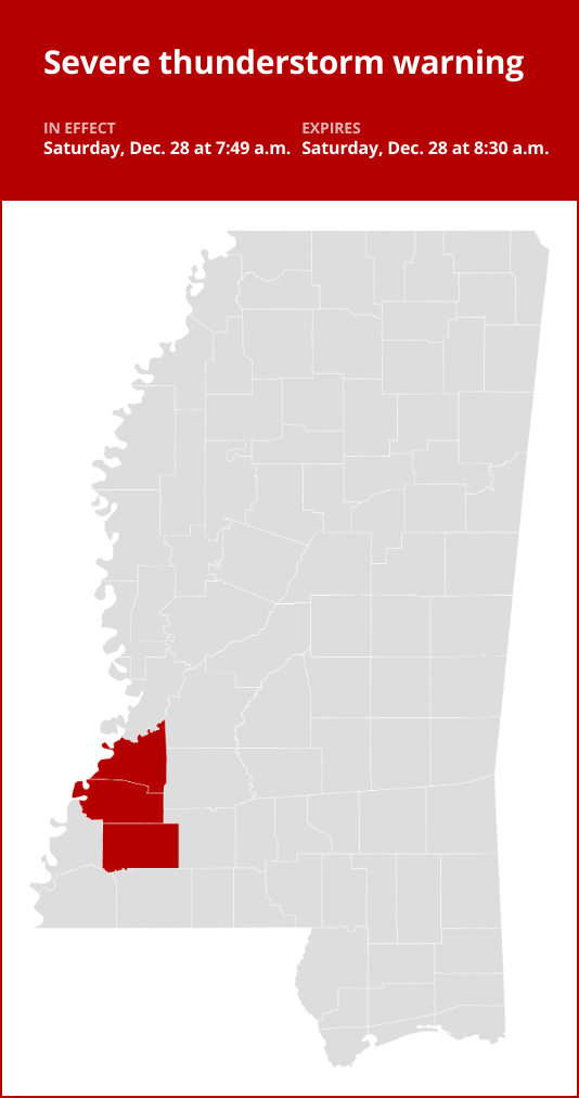
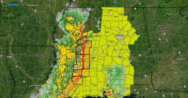
Thunderstorms with damaging winds and nickel-sized hail in southwest Mississippi Saturday
Thunderstorms with damaging winds and nickel-sized hail in southwest Mississippi Saturday
Published 7:53 am Saturday, December 28, 2024
On Saturday at 7:49 a.m. a severe thunderstorm warning was issued by the National Weather Service valid until 8:30 a.m. for Claiborne, Franklin and Jefferson counties.
The storms could bring nickel-sized hail (0.88 inches) and wind gusts of up to 60 mph.
“At 7:49 a.m., a severe thunderstorm was located over Hamburg, or 8 miles south of Fayette, moving northeast at 30 mph,” according to the NWS. “Expect damage to roofs, siding, and trees.”
Be aware that the thunderstorm may affect the following locations:
- Fayette and Mcnair around 7:55 a.m.
- Red Lick around 8:05 a.m.
- Blue Hill around 8:10 a.m.
- Union Church around 8:20 a.m.
According to the NWS, “For your protection move to an interior room on the lowest floor of a building. A Tornado Watch remains in effect until 3 p.m. for central and southwestern Mississippi.”

Preparing for approaching lightning: Expert safety advice
Each year, lightning strikes the United States approximately 25 million times, with the majority of these electrifying events occurring during the summer months. Unfortunately, lightning is responsible for claiming the lives of approximately 20 people annually, as reported by the NWS. The threat of lightning becomes more pronounced as thunderstorms draw nearer, peaking when the storm is directly overhead and gradually waning as it moves away.
To protect yourself during a thunderstorm, take these recommendations into consideration:
Lightning safety plan:
- When venturing outdoors, it’s crucial to have a lightning safety plan in place.
- Stay vigilant by monitoring the sky for ominous signs and listening for the telltale sound of thunder. If thunder is audible, it’s a clear indication of nearby lightning.
- Seek shelter promptly in a safe location, preferably indoors.
Indoors safety measures:
- Once you’ve found shelter indoors, abstain from using corded phones, electrical appliances, or plumbing fixtures, and refrain from approaching windows and doors.
- Lightning can follow conductive pathways, and these precautions reduce the risk of electrical surges.
Wait for the all-clear:
- After the last lightning strike or thunderclap, wait at least 30 minutes before resuming outdoor activities.
- Lightning can strike even when a storm has seemingly passed, so exercise caution.
When indoor shelter isn’t available:
If you find yourself outdoors with no access to indoor shelter during a thunderstorm, take these steps to maximize your safety:
- Avoid open fields, hilltops, or ridge crests, as they expose you to greater lightning risk.
- Steer clear of tall, isolated trees and other prominent objects. In forested areas, stay close to lower stands of trees.
- If you’re in a group, ensure that individuals are spaced out to prevent lightning current from transferring between people.
- Camping in an open setting during a thunderstorm is strongly discouraged. If no alternative exists, set up camp in a valley, ravine, or other low-lying areas. Remember that a tent offers no protection against lightning.
- Do not approach water bodies, wet objects, or metal items. Although water and metal do not attract lightning, they conduct electricity effectively and can pose significant risks.
In summary, when facing the threat of lightning, preparedness and vigilance are your best allies. By following these guidelines, you can significantly reduce the likelihood of lightning-related incidents and prioritize your safety.
Mastering wet roads: Safety tips for heavy rainfall
When heavy rain strikes, safety is paramount. Equip yourself with these guidelines from the NWS to navigate wet roads and avoid hazards:
Beware of swollen waterways:
Avoid parking or walking in close proximity to culverts or drainage ditches, as the swiftly moving water during heavy rain can potentially carry you away.
Maintain safe driving distances:
The two-second rule for following distance is your ally in heavy rain. Extend it to four seconds to ensure safe spacing in adverse conditions.
Slow down and stay cautious:
If it is raining and the roads are wet, slow down. Take your foot off the accelerator and let your speed drop gradually. Never use the brakes suddenly because this may cause the car to skid.
Choose your lane wisely:
Stick to the middle lanes on multi-lane roads to minimize the risk of hydroplaning, as water tends to accumulate in outer lanes.
Prioritize visibility
Enhance your visibility in heavy rain by turning on your headlights. Watch out for vehicles in blind spots, as rain-smeared windows can obscure them.
Watch out for slippery roads:
The initial half-hour of rain is when roads are slickest due to a mixture of rain, grime, and oil. Exercise heightened caution during this period.
Keep a safe distance from large vehicles:
Don’t follow large trucks or buses too closely. The spray created by their large tires reduces your vision. Take care when passing them as well; if you must pass, do so quickly and safely.
Mind your windshield wipers:
Heavy rain can overload the wiper blades. When visibility is so limited that the edges of the road or other vehicles cannot be seen at a safe distance, it is time to pull over and wait for the rain to ease up. It is best to stop at rest areas or other protected areas.
When stopping by the roadside is your only option, position your vehicle as far off the road as possible, ideally beyond guardrails. Keep your headlights on and activate emergency flashers to alert other drivers of your position.
By following these safety measures, you can significantly reduce risks and ensure your well-being when heavy rain pours down. Stay informed about weather conditions and heed advice from local authorities to make your journey safe and sound.
Source: The National Weather Service
Attention residents of southwest Mississippi! Be prepared for severe weather this Saturday as thunderstorms with damaging winds and nickel-sized hail are forecasted to hit the area.It is important to take precautions to protect yourself and your property. Stay indoors during the storm, away from windows and doors. Secure any loose outdoor items that could be blown away by strong winds.
If you have a safe shelter, such as a basement or storm cellar, use it during the storm. Avoid driving or being outside when the severe weather hits.
Stay informed by monitoring weather updates from local news stations and the National Weather Service. Be prepared for power outages and have a plan in place in case of an emergency.
Stay safe, stay alert, and stay prepared for the potential severe weather on Saturday in southwest Mississippi.
Tags:
- Thunderstorms
- Damaging winds
- Nickel-sized hail
- Southwest Mississippi
- Severe weather
- Saturday forecast
- Severe thunderstorms
- Mississippi weather
- Weather alert
- Storm damage
#Thunderstorms #damaging #winds #nickelsized #hail #southwest #Mississippi #Saturday