Your cart is currently empty!
Tag: Evening
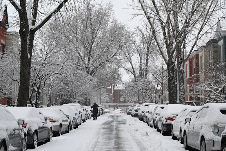
DC’s snowfall chances rise for Sunday evening
Conditions are shaping up for the D.C. area’s first notable snowfall of 2025 on Sunday night.
Conditions are shaping up for the D.C. area’s first notable snowfall of 2025 on Sunday night, with a chance the region could see several inches going into Monday morning.
“We have a good opportunity to see at least 3 inches of snow, if not more,” 7News First Alert Meteorologist Eileen Whelan said.
There will be mostly sunny skies and light winds Sunday, with temperatures hovering around 32 degrees. Clouds will arrive later in the evening, teeing up for snow chances.
“The cold air will be in place and the moisture will be there as well,” Whelan said, adding additional snow days could be possible.
The region could see a preview Friday afternoon as an arctic front moves through, bringing a rain and snow mix. Temperatures will reach the mid 40s.
Friday’s front “could bring us a quick coating of snow on maybe some of the grassy surfaces, but temperatures will be well above freezing,” Whelan said.
While heaps of snow aren’t expected Friday, D.C. Mayor Muriel Bowser is deploying the District Snow Team at noon Friday and crews in the city will begin treating roads with brine Thursday evening. D.C. is also encouraging residents and business owners to salt their sidewalks ahead of possible snowy weather.
The front will then bring freezing temperatures Saturday, with morning wind chills in the teens. Highs will reach the low 30s.
Here’s a look ahead at the weekend forecast.
FORECAST
THURSDAY EVENING: Partly cloudy
Temps: 30-38
Winds: West 5 mph
Wind Chills: 27-34
Easing winds with increasing clouds as we get ready for the next weather-maker Friday.OVERNIGHT: Partly cloudy
Lows: 26-32
Winds: West 5-10 mph
Partly Cloudy and dry overnight.FRIDAY: Mostly cloudy, chance of afternoon rain, snow from mainly 1 p.m. to 6 p.m.
Highs: 39-45
Winds: West 8-12 mph
Ahead of another push of cold air, highs for the day will reach the middle 40s. Latest guidance brings a chance for a wintry mix during the afternoon hours. Areas of rain, sleet, and snow will traverse across the DMV between 1-6 p.m. Temperatures will be above freezing when the moisture moves in, so plan for rain at the start in D.C. As colder air spills in, we could see a brief transition to sleet and snow. A coating of snow is possible on grassy areas, especially north and west of the district. Any lingering moisture could refreeze with temperatures rapidly falling below 32.SATURDAY: Mostly sunny
Highs: 30-35
Winds: West 10-15, gusts to 30 mph
Arctic air settles in for the first weekend of 2025. Morning wind chills in the teens will give way to wind chills in the 20s during the afternoon.SUNDAY: Mostly to partly sunny, cold
Highs: Around 32
Winds: Northwest 5-10 mph
Cold weather remains locked in place for the day under mostly sunny skies. Later in day, clouds will increase ahead of our next weather make which is likely to bring snow to region.SUNDAY NIGHT INTO MONDAY: WINTER ALERT
The first snow of the season is looking more likely starting late Sunday night and continuing into Monday. It’s still too early to pinpoint accumulations, an inch or more of snow is likely at this point across parts of the mid-Atlantic, however, forecast trends continue to evolve.CURRENT CONDITIONS
Get breaking news and daily headlines delivered to your email inbox by signing up here.
© 2025 WTOP. All Rights Reserved. This website is not intended for users located within the European Economic Area.
As the weekend approaches, DC residents should be prepared for the possibility of snowfall on Sunday evening. According to meteorologists, the chances of snow have increased for the nation’s capital, with a potential winter storm heading our way.While it is still too early to predict exact snowfall amounts, residents should be aware of the potential for slippery roads and reduced visibility. It is important to stay updated on weather forecasts and be prepared for changing conditions.
As always, make sure to have emergency supplies on hand, such as food, water, and blankets, in case of power outages or other emergencies. Stay safe and stay informed as we head into the weekend with the potential for winter weather in DC.
Tags:
- DC snowfall forecast
- Washington DC weather update
- Snowstorm heading towards DC
- Sunday evening snow in DC
- Winter weather alert for Washington DC
- DC snowstorm prediction
- Latest snowfall chances in DC
- DC weather advisory for Sunday
- Winter storm warning for Washington DC
- Snowfall forecast for DC metro area
#DCs #snowfall #chances #rise #Sunday #evening

NY weather: Wind advisory issued for Jefferson County until Monday evening
On Sunday at 3:01 a.m. a wind advisory was issued by the National Weather Service valid from 4 p.m. until Monday 7 p.m. for Jefferson County.
The weather service adds, “South to southwest winds 25 to 35 mph with gusts up to 50 mph expected.”
“Gusty winds will blow around unsecured objects. Tree limbs could be blown down and a few power outages may result,” describes the weather service. “Use extra caution when driving, especially if operating a high profile vehicle. Secure outdoor objects.”

Advance Local Weather Alerts is a service provided by United Robots, which uses machine learning to compile the latest data from the National Weather Service.
New York Weather Update: Wind Advisory Issued for Jefferson County until Monday EveningAttention residents of Jefferson County, a wind advisory has been issued for the area until Monday evening. Strong winds are expected to gust up to 40 mph, causing potential hazards such as downed trees and power lines.
It is advised to secure any loose outdoor items and take caution while driving, especially on bridges and overpasses. Stay updated on local weather reports and be prepared for possible power outages.
Please stay safe and take necessary precautions to protect yourself and your property during this wind advisory. Stay tuned for further updates on the weather conditions in Jefferson County.
Tags:
NY weather, Wind advisory, Jefferson County, Monday evening, weather alert, severe weather warning, NY forecast, wind gusts, weather update
#weather #Wind #advisory #issued #Jefferson #County #Monday #evening
Handmade Saturday Evening Fridge Magnets Metal 2.5×3.5″ 100’s in Store Vintage

Handmade Saturday Evening Fridge Magnets Metal 2.5×3.5″ 100’s in Store Vintage
Price : 7.95
Ends on : N/A
View on eBay
Looking to add a touch of vintage charm to your kitchen? Our handmade Saturday evening fridge magnets are the perfect addition! These metal 2.5×3.5″ magnets are available in a variety of designs, from retro advertisements to classic movie posters.With hundreds of options to choose from, you’re sure to find the perfect magnet to suit your style. These magnets are not only functional, but also make great decorative pieces for your fridge or magnetic board.
Visit our store today to browse our selection of vintage-inspired fridge magnets and add a touch of nostalgia to your kitchen decor!
#Handmade #Saturday #Evening #Fridge #Magnets #Metal #2.5×3.5 #100s #Store #Vintage, Magnetic storage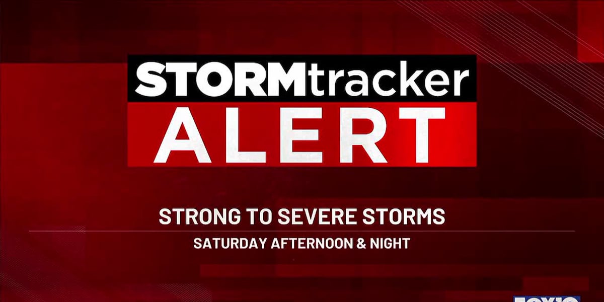
Strong to severe storms this evening and tonight
(WALA) – The Gulf Coast faces a significant severe weather threat from this afternoon through early Sunday morning. The highest risk (Level 4/5 Moderate Risk) is positioned mainly to our northwest, but includes small portions of Greene, Washington, and Clarke Counties.
Download the FOX10 Weather App
Most of the FOX10 viewing area is under either a Level 3/5 Enhanced Risk or Level 2/5 Slight Risk for severe weather. Here’s what you need to know:

STORMtracker Alert Summary: Severe weather late Saturday through overnight Saturday(WALA) Key Details: Timing and Rounds of Storms
Round 1: Late Afternoon to Early Evening
- Isolated, scattered storms may develop ahead of the main line, particularly in areas west of I-65. These storms could produce damaging winds, large hail, and isolated tornadoes, especially if our atmosphere recovers from the morning rainfall and storms.
Round 2: Main Event (Overnight)
- A squall line will move through the region between 9 PM and 7 AM from west to east. This line will bring the highest threat of widespread damaging winds (up to 70 mph) and embedded tornadoes. Areas west of I-65 (Washington, Clarke, Choctaw, and Mobile counties) will see the line earlier, with eastern counties (Escambia AL/FL, Santa Rosa, and Okaloosa) impacted closer to pre-dawn hours. The highest overall threat for severe weather also exists north and west of I-65.

SPC Severe Weather Outlook – Saturday and Saturday Night(WALA) 
SPC Local Severe Weather Outlook – Saturday and Saturday Night(WALA) Severe Weather Hazards
Tornadoes
- Tornadoes are possible, particularly across areas west of I-65. Some tornadoes may be strong (EF2+) and long-tracked, especially closer to the Moderate Risk zone in southeast Mississippi and southwest Alabama.
Damaging Winds
- Widespread damaging winds are the most significant threat with gusts up to 70 mph, particularly along the squall line. These winds can cause downed trees, power outages, and structural damage.
Heavy Rain and Flooding
- Rainfall amounts of 1-2 inches are possible. While widespread flooding is not expected, saturated soils from Friday’s rain could lead to localized flooding, especially in areas experiencing training storms.

Coastal Flood Advisory – Causeway Flooding Possible(WALA) Coastal Hazards
- High Risk of Rip Currents: Dangerous surf conditions with 5-6 foot waves expected.
- Coastal Flood Advisory: Minor flooding possible along Mobile Bay during high tide, particularly affecting low-lying areas such as the Causeway.

Tornado Warning – What to Do(WALA) Preparation and Safety Tips
- Have multiple ways to receive warnings, especially overnight. This includes NOAA Weather Radio, weather apps (like the FOX10 Weather App), and enabled emergency alerts on your phone.
- Know your safe place: Lowest floor, interior room, away from windows. If you live in a mobile home, know the nearest shelter location.
- Charge your devices, and ensure flashlights and backup power sources are ready in case of power outages.
The storms downed trees and powerlines. Stay up to date with all the latest from your FOX10 weather team by downloading the FOX10 weather app.
Copyright 2024 WALA. All rights reserved.
Get ready for some intense weather tonight as strong to severe storms are expected to move through the area this evening. Meteorologists are predicting heavy rain, damaging winds, and the possibility of hail in some areas.It’s important to stay informed and stay safe during these storms. Make sure to secure any loose outdoor items, stay indoors if possible, and avoid driving through flooded roadways.
If you have any emergency supplies or a plan in place, now is the time to put them into action. Keep a close eye on weather updates and be prepared to take shelter if necessary.
Stay safe and stay informed during this active weather period. Let’s all work together to stay strong and weather this storm.
Tags:
- Severe weather alert
- Storm warning
- Extreme weather conditions
- Severe thunderstorms
- Weather update
- Emergency weather advisory
- Severe weather forecast
- Storm safety tips
- Weather alert system
- Severe storm preparedness.
#Strong #severe #storms #evening #tonight
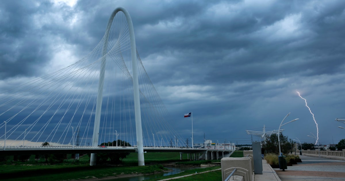
Isolated storms possible in North Texas Saturday evening, forecast says
Update:
5:14 p.m. Dec. 26, 2024: Updated with details about tornadoes and a death in Houston.
The National Weather Service says isolated to scattered storms are possible across parts of North Texas on Saturday evening, with the main threats being hail and lightning.
The forecast followed the severe thunderstorms and showers that swept through the Dallas-Fort Worth area in the morning.
Southeast Texas, particularly the Houston area, also experienced major storms, as well as tornados Saturday.
One person died and four people were injured in Brazoria County, south of Houston, the Associated Press reported. Around 10 homes were also damaged.
The NWS has also issued a tornado watch for this region until 9 p.m. Saturday, saying that numerous strong tornadoes are expected and gusts of up to 80 miles per hour are also likely. Hail of up to two-inch size is also possible, it says.
Texas Gov. Greg Abbott had already activated state emergency response resources earlier this week, citing an increased severe weather threat.
“As Texans and out-of-state visitors begin traveling after the Christmas holiday, it’s crucial that everyone regularly monitor road conditions, make an emergency plan, and heed the guidance of state and local officials,” Abbott said in a Dec. 26 news release.
The NWS tornado watch includes parts of Arkansas, Louisiana and Mississippi, which cover almost 2.4 million people.
Here’s the latest NBC5 forecast:
SUNDAY: AM patchy fog, turning mostly sunny and warm. Low: 50. High: 71.
MONDAY: Sunny and mild. Low: 45. High: 78.
TUESDAY (NEW YEAR’S EVE): Sunny and seasonable. Low: 36. High: 57.
WEDNESDAY (NEW YEAR’S DAY): Mostly sunny and cool. Low: 34. High: 53.
THURSDAY: Mostly sunny and cool. Low: 36. High: 55.
Will warm weather ring in the new year? Here’s what to expect in North Texas
Isolated storms possible in North Texas Saturday evening, forecast saysThe National Weather Service has issued a warning for isolated storms in North Texas on Saturday evening. While the majority of the region will remain dry, there is a chance for scattered thunderstorms to develop in some areas.
Residents are advised to stay weather aware and be prepared for sudden changes in weather conditions. Make sure to have a plan in place in case severe weather strikes, and stay tuned to local news and weather reports for updates.
Remember, it’s always better to be safe than sorry when it comes to severe weather. Stay informed, stay prepared, and stay safe.
Tags:
- North Texas weather forecast
- Isolated storms in North Texas
- Saturday evening weather outlook
- Severe weather potential in North Texas
- North Texas storm forecast
- Weather updates for North Texas
- Thunderstorm chances in North Texas
- North Texas weekend weather
- Forecast for Saturday evening in North Texas
- Severe weather alert for North Texas
#Isolated #storms #North #Texas #Saturday #evening #forecast
Handmade Saturday Evening Fridge Magnets Metal 2.5×3.5″ 100’s in Store Vintage

Handmade Saturday Evening Fridge Magnets Metal 2.5×3.5″ 100’s in Store Vintage
Price : 7.95
Ends on : N/A
View on eBay
Are you looking for a unique and charming addition to your refrigerator? Look no further than our Handmade Saturday Evening Fridge Magnets! These metal magnets are 2.5×3.5″ in size and come in a variety of vintage designs.We have 100’s of these magnets in store, each one lovingly crafted by hand to add a touch of nostalgia and whimsy to your kitchen decor. Whether you’re a fan of retro advertisements, classic movie posters, or quirky illustrations, we have a magnet for you.
Don’t settle for boring store-bought magnets when you can have a one-of-a-kind piece of art on your fridge. Stop by our store today and browse our selection of Handmade Saturday Evening Fridge Magnets. Your fridge will thank you!
#Handmade #Saturday #Evening #Fridge #Magnets #Metal #2.5×3.5 #100s #Store #Vintage, Magnetic storage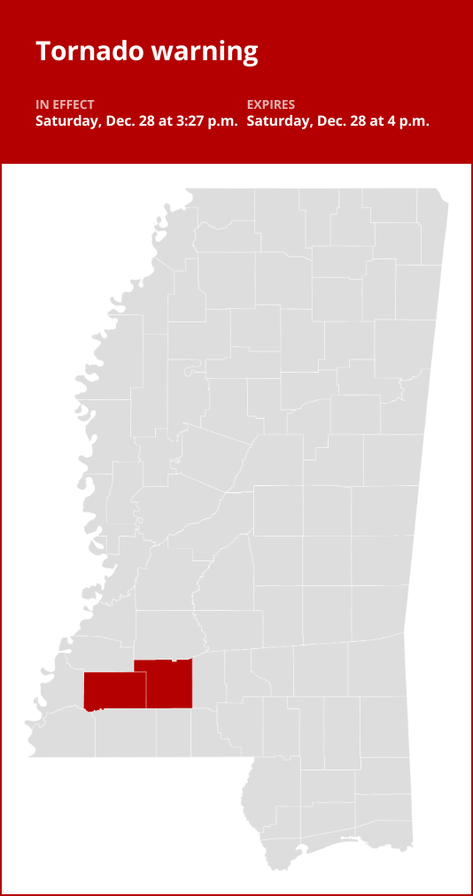
Update: Tornado warning for Franklin and Lincoln counties early Saturday evening
Update: Tornado warning for Franklin and Lincoln counties early Saturday evening
Published 3:32 pm Saturday, December 28, 2024
An updated tornado warning was issued by the National Weather Service on Saturday at 3:27 p.m. in effect until 4 p.m.
“At 3:27 p.m., a confirmed large and extremely dangerous tornado was located near Mccall Creek, or 7 miles east of Meadville, moving northeast at 35 mph,” states the NWS. “You are in a life-threatening situation. Flying debris may be deadly to those caught without shelter. Mobile homes will be destroyed. Considerable damage to homes, businesses, and vehicles is likely and complete destruction is possible.”
The following locations are predicted to be affected by the tornado:
- Mccall Creek and New Hope around 3:30 p.m.
- Vaughn around 3:35 p.m.
The NWS adds, “To repeat, a large, extremely dangerous and potentially deadly tornado is on the ground. To protect your life, TAKE COVER NOW! Move to a basement or an interior room on the lowest floor of a sturdy building. Avoid windows. If you are outdoors, in a mobile home, or in a vehicle, move to the closest substantial shelter and protect yourself from flying debris.”

Tornado watches and warnings: Your safety guide
When it comes to tornadoes, understanding the difference between a Tornado watch and a Tornado warning can be a matter of life and death. Let’s break it down:
Tornado watch: Be prepared!
- A Tornado watch is your advance warning that conditions are ripe for tornado formation.
- It’s your cue to review and discuss your emergency plans, check your supplies, and locate your safe room.
- While it doesn’t mean a tornado is imminent, it’s a heads-up that you should be ready to act quickly if a Tornado warning is issued or if you suspect a tornado is approaching.
- Watches come from the Storm Prediction Center and often cover a large area, potentially spanning multiple counties or even states.
Tornado warning: Take action!
- A Tornado warning means a tornado has been spotted or detected by weather radar.
- This is the real deal – there’s an immediate threat to life and property.
- Your response should be quick: seek shelter in an interior room on the lowest floor of a sturdy building, away from windows.
- If you’re in a mobile home, a vehicle, or caught outdoors, find the nearest substantial shelter and protect yourself from flying debris.
- Warnings are issued by your local forecast office and pinpoint a much smaller area, typically the size of a city or a small county, where a tornado has been identified, either by radar or by trained spotters and law enforcement.
Knowing the difference between these two alerts is essential in staying safe during tornado season. Stay informed, have a plan, and act promptly when danger approaches.
Prepare for a tornado
Be weather-ready:
Keep an eye on the weather forecast to stay informed about tornado risks. Tune in to local news or a NOAA Weather Radio for updates on tornado watches and warnings
Sign up for alerts:
Know how your community sends warnings. Some communities have outdoor sirens. Others depend on media and smartphones to alert residents of severe storms capable of producing tornadoes.
Establish a communication plan:
Create a family emergency plan that includes a designated meeting place and important contact information. If your home lacks a basement, identify a nearby safe building, like a church or a relative’s house, that you can reach quickly.
Choose a secure shelter:
Pick a safe room in your home, such as a basement, storm cellar, or an interior room on the lowest floor with no windows.
Practice your plan:
Conduct regular family drills for severe thunderstorms so everyone knows what to do when a tornado threat arises. Ensure that all family members are aware of the safe location to seek shelter, and don’t forget about your pets if time permits.
Secure your home:
Consider reinforcing your safe room for added protection. You can find plans for fortifying an interior room on the Federal Emergency Management Agency website.
Help your neighbor:
Encourage your loved ones to prepare for the possibility of tornadoes. Take CPR training so you can help if someone is hurt.
What to do when a tornado strikes
When a tornado strikes, taking swift action is crucial to ensuring your safety and minimizing potential harm. Follow these guidelines from the NWS:
Stay informed:
Remain vigilant and stay updated by listening to local news broadcasts or a NOAA Weather Radio for tornado watches and warnings.
At home:
If you find yourself under a tornado warning while at home, head to your basement, a designated safe room, or an interior space away from windows. Ensure your pets are safe if time permits.
At work or school:
Follow your tornado drill and proceed to your tornado shelter location quickly and calmly. Stay away from windows and do not go to large open rooms such as cafeterias, gymnasiums, or auditoriums.
Outdoors:
If you’re outdoors and a tornado is approaching, seek immediate shelter inside a sturdy building. Sheds, storage facilities, mobile homes, and tents are not safe. If there’s time, make your way to a secure structure.
In a vehicle:
Being inside a vehicle during a tornado is highly unsafe. Your best course of action is to drive to the nearest shelter. If reaching shelter is not possible, either stay inside your car while covering your head, or abandon the vehicle and seek safety in a low-lying area such as a ditch or ravine.
Remember, acting swiftly and following safety protocols are essential for your well-being when a tornado is imminent.
Source: The National Weather Service
Attention residents of Franklin and Lincoln counties,We want to provide you with an update on the tornado warning issued for our area early Saturday evening. The National Weather Service has issued a tornado warning for Franklin and Lincoln counties until 7:30 pm. Please take this warning seriously and seek shelter immediately.
It is important to stay informed and follow all safety precautions during severe weather events. Stay tuned to local news and weather reports for further updates and instructions.
Please stay safe and take all necessary precautions to protect yourself and your loved ones. Our thoughts are with everyone in the affected areas.
Stay safe,
[Your Name]
Tags:
tornado warning, Franklin County, Lincoln County, early Saturday evening, severe weather update, emergency alert, storm warning, severe weather warning, tornado safety, weather advisory
#Update #Tornado #warning #Franklin #Lincoln #counties #early #Saturday #evening
JIN JUNG SUNG Soothing Non-sticky Face Moisturizer Essence Serum 5 Oz Oily Dry Sensitive Skin Tone Evening Deep Inner Moisturizing 7-Hyaluronic Acids Beta-Glucan Niacinamide Men Women Korean Skincare
Price: $21.99
(as of Dec 28,2024 12:52:20 UTC – Details)
ULTRA HYDRATING: This facial essence, serum contains 8 moisturizing ingredients including Glycerin, Ceramide, Beta Glucan, and Hyaluronic Acid The ingredients in this hydrating face serum works in synergy to create high effects for drying, dehydrated skin.
SOOTHING INGREDIENTS: This hydrating serum not only improves your skin barrier, but also soothes irritated, sensitive, damaged skin
YOUTHFUL GLOW SERUM: Pure hydration for your skin to achieve glow-iness. Collagen, Peptide, Niacinamide, Adenosine provides nourishment to the face to accentuate your beauty. Timeless skin care that takes care of your wrinkles and aging signs.
DEEPLY ABSORBING: The natural derived ingredients of ENS Jin Jung Sung and the perfect balance of 4 moisturizing factors formulated in a clear liquid, brings good care towards your skin. Great skincare for dryness, wrinkle, and acne. Work’s on all skin type
CLEAN PROMISE: JIN JUNG SUNG Skin Care Products are formulated WITHOUT 1500+ Ingredients such as Parabens, Sulfates, Synthetic Fragrance, PEGs, Petroleum, and Formaldehyde releasors. Our products are certified cruelty-free and VEGAN. CLEAN BEAUTY for HUMAN, EARTH- distinct improvements on dry skin after 1-week useCustomers say
Customers find that the skin serum leaves their skin hydrated and soft. They appreciate its effectiveness as a toner, essence, or serum. The mild scent is appreciated, and the design is lovely. Many customers like the ingredients and longevity of the product. However, opinions differ on the thickness.
AI-generated from the text of customer reviews
Are you tired of dealing with dry, oily, or sensitive skin? Look no further than the JIN JUNG SUNG Soothing Non-sticky Face Moisturizer Essence Serum! This 5 oz serum is specially formulated to provide deep inner moisturizing for all skin types, including oily, dry, and sensitive skin tones.With a unique blend of 7-Hyaluronic Acids, Beta-Glucan, and Niacinamide, this serum works to hydrate and nourish your skin without leaving a sticky residue. Whether you’re a man or a woman, this Korean skincare product is perfect for adding moisture and balance to your daily routine.
Say goodbye to dull, dehydrated skin and hello to a radiant, healthy complexion with the JIN JUNG SUNG Soothing Non-sticky Face Moisturizer Essence Serum. Try it today and experience the benefits for yourself!
#JIN #JUNG #SUNG #Soothing #Nonsticky #Face #Moisturizer #Essence #Serum #Oily #Dry #Sensitive #Skin #Tone #Evening #Deep #Moisturizing #7Hyaluronic #Acids #BetaGlucan #Niacinamide #Men #Women #Korean #Skincare,ʼjiyu korean skincare anti-aging
Saturday Evening Fridge Magnets Metal 2.5×3.5″ 100’s in Store Vintage

Saturday Evening Fridge Magnets Metal 2.5×3.5″ 100’s in Store Vintage
Price : 7.95
Ends on : N/A
View on eBay
Are you a fan of vintage décor? Looking to add a touch of charm to your kitchen? Look no further than our Saturday Evening Fridge Magnets Metal 2.5×3.5″ 100’s in Store Vintage collection! These adorable magnets are perfect for adding a pop of personality to your fridge or any magnetic surface.Made from durable metal, these magnets are designed to last. With 100 different vintage designs to choose from, you’ll have plenty of options to mix and match to create your own unique look. Whether you’re a fan of retro advertisements, classic cartoons, or old-school typography, there’s something in this collection for everyone.
So why wait? Head to our store and pick up a set of Saturday Evening Fridge Magnets Metal 2.5×3.5″ 100’s in Store Vintage today and start decorating your space with a touch of nostalgia.
#Saturday #Evening #Fridge #Magnets #Metal #2.5×3.5 #100s #Store #Vintage, Magnetic storage
Handmade Saturday Evening Fridge Magnets Metal 2.5×3.5″ 100’s in Store Vintage

Handmade Saturday Evening Fridge Magnets Metal 2.5×3.5″ 100’s in Store Vintage
Price : 7.95
Ends on : N/A
View on eBay
Are you looking to add a touch of vintage charm to your kitchen decor? Look no further than our handmade Saturday evening fridge magnets! These metal magnets are 2.5×3.5″ in size and feature a variety of unique and nostalgic designs.With hundreds of magnets in store, you’re sure to find the perfect ones to complement your kitchen style. Whether you’re a fan of retro advertisements, classic movie posters, or vintage travel photos, we have something for everyone.
These magnets also make great gifts for friends and family members who appreciate handmade and one-of-a-kind items. So why not stop by our store and browse our selection of vintage fridge magnets today? Your fridge will thank you!
#Handmade #Saturday #Evening #Fridge #Magnets #Metal #2.5×3.5 #100s #Store #Vintage, Magnetic storage


