Your cart is currently empty!
Tag: Floods
Today’s top weather news: South storms threaten 17 million people with floods across 10 states
Welcome to the Daily Weather Update from FOX Weather. It’s Thursday, Jan. 30, 2025. Start your day with everything you need to know about today’s weather. You can also get a quick briefing of national, regional and local weather whenever you like with the FOX Weather Update podcast.
Dallas faces slow morning commute as flooding rain, severe thunderstorms barrel across South
Millions of people in the Dallas–Fort Worth Metroplex are facing a tough morning commute as a slow-moving, cross-country storm slides across the region, triggering flooding rain and severe weather.
More than 4 million people in cities like Dallas, Arlington and Plano have been included in a Flash Flood Warning until at least 8 a.m. CT, and additional Flash Flood Warnings were issued to the south of Dallas.
As the storm system continues to slide off to the east, more than 17 million people from eastern Texas to the lower Mississippi Valley will be at risk of severe thunderstorms on Thursday.
The main threats will be the risk of hail, damaging wind gusts and even some tornadoes.

This graphic shows the severe weather threat on Thursday and Friday.
(FOX Weather)
Wildfires erupt in Helene-ravaged area of North Carolina
At least three wildfires ignited on Wednesday near North Carolina towns that were devastated by Hurricane Helene. The largest of the fires was estimated to have consumed 200 acres near the town of Marion and forced evacuations.
The state’s governor said a shelter had been opened at a local church, but it remained unclear how many people were in the evacuation notice since many homes were destroyed in the region more than four months ago.

Photo of the Crooked Creek Fire burning on Jan. 29, 2025.
(Sarah Jane Gilliam)
Major low to blast Hawaii with heavy rain, flooding and damaging winds
A powerful storm system will produce heavy rainfall, gusty winds and rough waves throughout the Hawaiian Islands for the remainder of the workweek.
The National Weather Service office in Honolulu has issued a Flood Watch for all islands from Wednesday through Friday afternoon as rain rates of 2-3 inches per hour are expected for some areas.
The rain and flash flooding also bring an increased risk for mudslides and landslides for much of the islands.

Water blasts down Waimea Falls on Oahu.
(@makaiclicks/Instagram)
Before you go
Here are a few more stories you might find interesting.
Need more weather? Check your local forecast plus 3D radar in the FOX Weather app. You can also watch FOX Weather wherever you go using the FOX Weather app, at FOXWeather.com/live or on your favorite streaming service.
It’s easy to share your weather photos and videos with us. Email them to weather@fox.com or add #FOXWeather to your post on your favorite social media platform.
Today, severe storms are threatening 17 million people across 10 states in the South with the possibility of dangerous floods. With heavy rain and strong winds expected to hit the region, residents are being urged to take precautions and stay informed about the weather conditions.The storms are forecasted to bring significant rainfall to areas already saturated from recent weather events, increasing the risk of flash flooding and river flooding. The states at highest risk include Texas, Louisiana, Mississippi, Alabama, Georgia, Florida, South Carolina, North Carolina, Tennessee, and Kentucky.
Residents in these areas are advised to stay updated on weather alerts and warnings, avoid driving through flooded roads, and have an emergency plan in place in case of evacuation. Local officials are closely monitoring the situation and are prepared to respond to any emergencies that may arise.
As the storms continue to move through the region, it is crucial for residents to stay vigilant and prioritize their safety. By taking necessary precautions and staying informed, we can work together to weather this storm and protect our communities. Stay safe, everyone.
Tags:
weather news, South storms, floods, severe weather, natural disasters, weather updates, weather alerts, extreme weather, storm warnings, flood warnings, weather forecast, climate news, emergency preparedness, disaster relief, 10 states affected, 17 million people at risk
#Todays #top #weather #news #South #storms #threaten #million #people #floods #statesStarbucks’ Niccol aims to tame the chain’s mobile order floods
By Juveria Tabassum and Waylon Cunningham
(Reuters) – Starbucks’ new CEO, Brian Niccol, has a vision to make Starbucks into a classic coffeehouse, but he has to contend with an unusual challenge: the company’s mobile orders are as disruptive as they are popular.
“They come in flooding faster than our customer can get there,” Niccol said in a call with investors on Tuesday. He said baristas’ rush to pile those orders on the counter comes at the expense of providing a more personal touch to in-store customers.
Niccol called out mobile ordering as a bottleneck five times during the call, and said the company — which on Tuesday posted a smaller-than-expected drop in comparable sales — would work toward sequencing mobile orders with the help of an algorithm to improve efficiency behind the counter.
In some ways, Starbucks’ abundance of mobile orders has presented an opposite problem to what Niccol faced six years ago when he was CEO of Mexican restaurant chain Chipotle when he oversaw the launching of a mobile app and drive-through lanes dedicated to orders from that app, called Chipotlanes.
Niccol told investors in October 2018 that he believed less than half of Chipotle’s customers knew they could order through digital channels. “We need to improve that dramatically,” he said at the time.
Starbucks introduced mobile ordering in 2015, and customers quickly took advantage of it.
Mobile orders took precedence for Starbucks under Niccol’s predecessor Laxman Narasimhan as the company focused on driving traffic through its rewards program members tapping into offers and discounts on the app.
In contrast, comfortable seating, ceramic mugs and baristas with Sharpies and personalized messages on coffee cups have been at the center of Niccol’s attempt to take Starbucks back to its roots, and the hustle of mobile orders stands counterintuitive to that strategy.
The company is piloting an in-store prioritization algorithm to sequence mobile orders away from the current first-come, first-served basis, said Niccol, who was awarded compensation of nearly $96 million in 2024, a year in which he joined Starbucks as CEO in September. The pay package made Niccol one of the highest-paid executives in corporate America.
“I was in one of our stores this morning where we’ve already started to put this algorithm in,” Niccol said. “That happens behind the scenes, and it smoothes out those rushes of mobile orders such that our teams are able to provide great moments of connection for the in-cafe customer and the mobile order customer as well.”
(Reporting by Juveria Tabassum in Bengaluru and Waylon Cunningham in New York; Editing by Leslie Adler)
Starbucks’ Niccol Aims to Tame the Chain’s Mobile Order FloodsIn recent years, Starbucks has faced a growing challenge with the rise of mobile ordering. While convenient for customers, the surge in mobile orders has led to long wait times and crowded stores, causing frustration for both customers and baristas.
To address this issue, Starbucks CEO Kevin Johnson has appointed former Taco Bell CEO Brian Niccol as the new head of Starbucks’ operations. Niccol is known for his innovative approach to managing high demand and streamlining operations, making him a perfect fit for tackling Starbucks’ mobile order floods.
With Niccol at the helm, Starbucks is rolling out new strategies to improve its mobile ordering system, such as implementing order-ahead pick-up stations, expanding delivery options, and optimizing store layouts to accommodate the influx of mobile orders.
By leveraging Niccol’s expertise in managing high-volume orders, Starbucks is poised to enhance the overall customer experience and maintain its position as a leader in the coffee industry. Stay tuned for updates on Starbucks’ efforts to tame the chain’s mobile order floods under Niccol’s leadership.
Tags:
- Starbucks
- Niccol
- mobile orders
- coffee chain
- Starbucks CEO
- digital ordering
- Starbucks app
- mobile order floods
- coffee industry
- Starbucks news
#Starbucks #Niccol #aims #tame #chains #mobile #order #floods

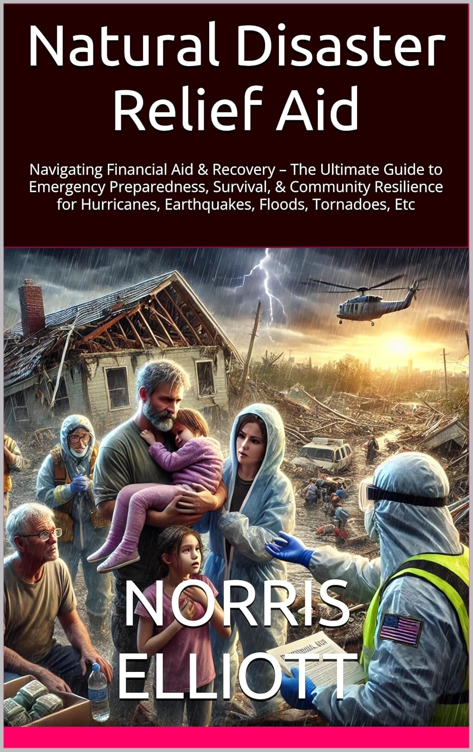
Natural Disaster Relief Aid : Navigating Financial Aid & Recovery – The Ultimate Guide to Emergency Preparedness, Survival, & Community Resilience for Hurricanes, Earthquakes, Floods, Tornadoes, Etc
Price: $2.99
(as of Dec 22,2024 23:17:50 UTC – Details)
ASIN : B0DK46B84Q
Publisher : NORRIS ELLIOTT BOOKS/ELLIONAIRE BOOKS (October 14, 2024)
Publication date : October 14, 2024
Language : English
File size : 4150 KB
Text-to-Speech : Enabled
Screen Reader : Supported
Enhanced typesetting : Enabled
X-Ray : Not Enabled
Word Wise : Enabled
Print length : 265 pages
When natural disasters strike, the impact can be devastating, leaving communities in need of immediate relief aid and support. In times of crisis, it is crucial to have a plan in place for emergency preparedness, survival, and recovery.In this ultimate guide, we will discuss how to navigate financial aid and recovery resources for various natural disasters such as hurricanes, earthquakes, floods, tornadoes, and more. From securing emergency funds to rebuilding your community, we will cover everything you need to know to weather the storm and come out stronger on the other side.
1. Emergency Preparedness: The first step in navigating natural disaster relief aid is to have a solid emergency preparedness plan in place. This includes creating an emergency kit, establishing a communication plan with loved ones, and knowing your evacuation routes. By being prepared, you can minimize the impact of a disaster and ensure the safety of yourself and your community.
2. Financial Aid: In the aftermath of a natural disaster, financial aid can be crucial for rebuilding and recovery. There are various sources of financial aid available, including government assistance, nonprofit organizations, and insurance policies. It is important to research and apply for all available resources to ensure you have the support you need to recover.
3. Community Resilience: Building community resilience is essential for long-term recovery and sustainability. By coming together and supporting one another, communities can bounce back stronger after a disaster. This includes organizing volunteer efforts, supporting local businesses, and advocating for policies that promote disaster preparedness and resilience.
4. Survival Tips: During a natural disaster, it is important to prioritize your safety and well-being. This includes staying informed about the latest updates and warnings, following evacuation orders, and seeking shelter in a safe location. By staying calm and following safety guidelines, you can increase your chances of survival during a disaster.
5. Recovery Efforts: After a natural disaster, recovery efforts can be a long and challenging process. It is important to have a clear plan for rebuilding your home, community, and life. This may involve working with contractors, applying for grants and loans, and seeking emotional support for trauma and loss. By staying focused and resilient, you can overcome the challenges of recovery and move forward with hope and strength.
In conclusion, navigating natural disaster relief aid requires careful planning, resilience, and community support. By following the tips and resources outlined in this guide, you can be better prepared to weather the storm and rebuild stronger than ever before. Remember, you are not alone – together, we can overcome any challenge and emerge stronger on the other side.
#Natural #Disaster #Relief #Aid #Navigating #Financial #Aid #Recovery #Ultimate #Guide #Emergency #Preparedness #Survival #Community #Resilience #Hurricanes #Earthquakes #Floods #Tornadoes, Disaster Recovery
WHAT TO DO AFTER YOUR HOUSE FLOODS: A STEP-BY-STEP RECOVERY GUIDE
Price: $14.99
(as of Dec 01,2024 04:43:02 UTC – Details)
ASIN : B0DDCDCGYF
Publisher : Independently published (August 15, 2024)
Language : English
Paperback : 88 pages
ISBN-13 : 979-8336020090
Item Weight : 6.6 ounces
Dimensions : 6 x 0.2 x 9 inches
WHAT TO DO AFTER YOUR HOUSE FLOODS: A STEP-BY-STEP RECOVERY GUIDEExperiencing a flood in your home can be a devastating and overwhelming experience. It’s important to know what steps to take in order to begin the recovery process and get your home back to its pre-flood condition. Here is a step-by-step guide on what to do after your house floods:
1. Ensure safety: Before entering your home, make sure it is safe to do so. Check for any structural damage, electrical hazards, or gas leaks. If there is any doubt about the safety of your home, contact a professional to assess the situation.
2. Document the damage: Take photos and videos of the flood damage for insurance purposes. This will help you when filing a claim with your insurance company.
3. Contact your insurance company: Notify your insurance company as soon as possible to start the claims process. They will guide you through the necessary steps and provide information on what is covered under your policy.
4. Remove water: Begin by removing any standing water from your home. Use a wet/dry vacuum, pumps, or buckets to extract the water. Open windows and doors to help with ventilation and drying.
5. Dry out the affected areas: Use fans, dehumidifiers, and air movers to help dry out the affected areas. This will help prevent mold growth and further damage to your home.
6. Remove damaged belongings: Sort through your belongings and remove any items that have been damaged beyond repair. Dispose of these items properly and document them for insurance purposes.
7. Clean and sanitize: Thoroughly clean and sanitize all surfaces that have come into contact with floodwater. Use a mixture of water and bleach to disinfect and prevent mold growth.
8. Check for mold: Keep an eye out for any signs of mold growth in your home. If you suspect mold, contact a professional mold remediation company to assess and remove it.
9. Repair and restore: Once your home is dry and clean, begin the repair and restoration process. This may include replacing drywall, flooring, insulation, and other damaged materials.
10. Take preventive measures: To prevent future flooding, consider installing a sump pump, waterproofing your basement, and maintaining your gutters and downspouts.
Remember, recovering from a flood takes time and patience. Be sure to reach out to family, friends, or professionals for support during this challenging time. With proper care and attention, your home will be back to normal before you know it.
#HOUSE #FLOODS #STEPBYSTEP #RECOVERY #GUIDE
From Fire to Floods: How to Safeguard Your Data Center Against Natural Disasters
Natural disasters can strike at any time, posing a significant threat to data centers and the critical information they house. From wildfires to floods, these events can cause devastating damage, resulting in data loss, downtime, and potential financial loss for businesses. To safeguard your data center against natural disasters, it is essential to have a comprehensive disaster recovery plan in place.One of the first steps in safeguarding your data center is to assess the potential risks in your area. Identify the types of natural disasters that are most likely to occur, such as wildfires, floods, hurricanes, or earthquakes. Once you have a clear understanding of the risks, you can develop a plan to mitigate their impact on your data center.
One of the most critical aspects of safeguarding your data center against natural disasters is to ensure that your facility is located in a safe and secure area. Avoid building data centers in high-risk areas prone to wildfires, floods, or other natural disasters. If relocation is not possible, consider implementing additional protective measures, such as installing fire-resistant materials, flood barriers, or earthquake-proof structures.
Having a robust backup and recovery strategy is essential for protecting your data center from natural disasters. Regularly backup your data and store copies in multiple locations, including offsite or in the cloud. This will ensure that your critical information is safe and accessible in the event of a disaster.
In addition to backups, it is also important to test your disaster recovery plan regularly. Conducting drills and simulations will help identify any weaknesses in your plan and enable you to make necessary adjustments. It is crucial to have clear protocols in place for evacuating personnel, shutting down equipment, and restoring operations in the event of a disaster.
Furthermore, invest in state-of-the-art monitoring and surveillance systems to detect potential threats early on. Advanced sensors can help alert you to changes in temperature, humidity, or other environmental factors that may indicate a potential disaster. By detecting these warning signs early, you can take proactive measures to protect your data center and prevent catastrophic damage.
Lastly, establish partnerships with local emergency services and disaster response organizations to ensure a swift and coordinated response in the event of a natural disaster. Having a network of support can help minimize the impact of the disaster and facilitate a quicker recovery process.
In conclusion, safeguarding your data center against natural disasters requires a proactive and comprehensive approach. By assessing risks, implementing protective measures, maintaining backups, testing disaster recovery plans, investing in monitoring systems, and establishing partnerships, you can minimize the impact of natural disasters on your data center and ensure the safety of your critical information.


