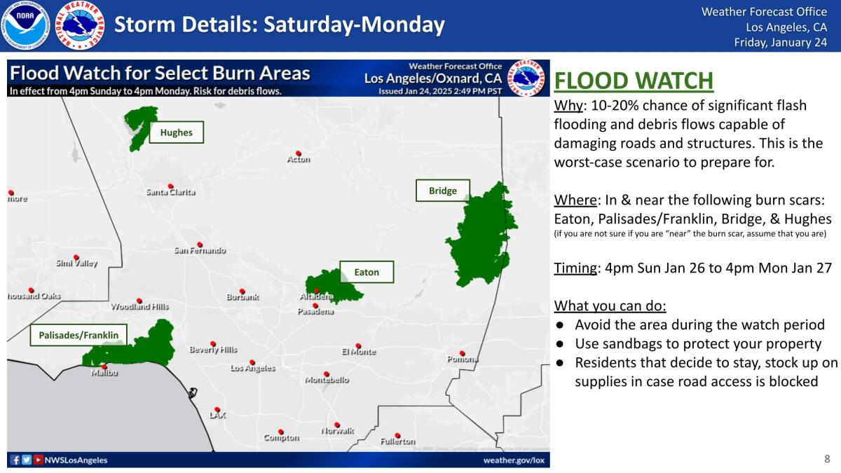
• There is a 10% to 20% chance of flash flooding, debris flow in some burned areas
• Damaging landslides are not the most likely scenario
• But the threat is high enough to ask people to prepare
Areas recently burned by wildfires in Los Angeles County are at some risk for flooding and landslides as Southern California prepares this weekend for its first significant rain of the winter.
“The threat is high enough to prepare for the worst-case scenario,” the National Weather Service office in Oxnard said on social media.
Forecasters said there is now a 10% to 20% chance of significant flash flooding and debris flow capable of damaging roads and homes in the most vulnerable recently burned areas, namely, the areas of the Palisades and Franklin fires around Pacific Palisades and Malibu, the Eaton fire around Altadena and Pasadena, the Hughes fire around Lake Castaic, and the Bridge fire in the Angeles National Forest north of Glendora.
The Bridge fire burned more than 56,000 acres in Los Angeles and San Bernardino counties in the autumn, destroying 81 structures and injuring eight firefighters.
Based on a U.S. Geological Survey assessment, these burned areas have the greatest potential for significant debris flow, said Ryan Kittell, a weather service meteorologist.
“They’re some of the freshest burn scars. They’re close to communities and/or vulnerable infrastructure. And the orientation of the terrain would favor those areas, in particular, having the higher chances, the higher potentials, for those higher totals and rainfall intensities,” Kittell said.
The probability of flooding and debris flow in those recently burned areas, issued Friday afternoon, is up from the 5% to 10% chance that was forecast a day earlier. “While damaging debris flows are not the most likely outcome, there is still a lot of uncertainty with this storm,” the weather service said.

Animated infographic shows a debris flow works
Recently burned areas are at risk for damaging floods and landslides because the heat from fire makes it harder for water to be absorbed through the top layer of soil. The soils become repellent to water, which then starts flowing on the surface downhill and picks up rock and debris.
That can result in “mudflows,” in which water starts rushing down hillsides with only mud, generally less than 15 feet, as well as more destructive and potentially deadly “debris flow” where rushing water downhill also picks up rocks, branches and sometimes massive boulders. Mudflows and debris flow are types of landslides.
“The most likely outcome is for no significant debris flows, but there’s a high-enough chance to definitely amplify the message that it’s there, it’s on the table, that the threat is increasing,” Kittell said. The chance of debris flow is “still a threat that people should at least plan for and take into consideration.”
“The most likely outcome is that there might be some shallow debris flows that are kind of minor impacts,” Kittell added.
The timing
Forecasters with the weather service issued a flood watch for the time period of highest risk — from 10 a.m. Sunday through 4 p.m. Monday.
Sunday night will be the period of particularly high concern, said weather service meteorologist Ryan Kittell.
A flood watch is issued when weather conditions are favorable for flooding. “It does not mean flooding will occur, but it is possible,” the weather service says.
Among the weather service’s recommendations: Avoid recently burned areas during that period. Use sandbags to protect property. And residents who do decide to stay can “stock up on supplies in case road access is blocked.”
(National Weather Service)
The planned flood watch did not include the Mountain fire burn scar in Ventura County.
Light rain had already begun to fall in some areas of Los Angeles on Saturday afternoon. The chance of rainfall will pick up through the afternoon in Los Angeles and Ventura counties, and the time of highest rain intensity is expected between Sunday afternoon through Monday at noon for Los Angeles and Ventura counties. It’ll be common for the rain that does appear to be light, and appear off and on throughout the weekend into Monday.
This is “a slow moving storm, so it’s going to be stubborn. It’s going to hang around,” said Alex Tardy, meteorologist with the National Weather Service office in San Diego. “It’s going to send waves of moisture through Monday. So I think that’s really going to add up to significant rain and snow.”
Forecasters have increased their projections of how much rain could fall. The adjusted forecast is a result of the low pressure system, dropping in from Canada, appearing to veer a little bit more to the west — a little bit more off the coast of Southern California — than initially expected, which would make this storm wetter.
That’s resulting in the “increased concerns for debris flows over some of the burned scars,” Kittell said.
Still, considerable uncertainty remained Saturday afternoon, with outcomes dependent on the storm’s precise path and speed, said Kristan Lund, meteorologist with the National Weather Service in Oxnard.
If the low pressure system wobbles a bit west toward the water, it will pick up more moisture and result in higher rainfall totals, while a more inland route to the east will mean less rain, she said. And if the storm ends up being a little slower than expected, it could sit over one area and prolong rainfall there, or result in heavier rainfall across the board, she said.
“These patterns tend to be a little more unpredictable in terms of you really don’t know until it arrives what it’s going to end up doing,” she said.

(National Weather Service)
The mountains of Los Angeles and Ventura counties could get 2 to 3 inches of rain, while half an inch to 1 inch are possible elsewhere.
Between Saturday and Monday, Thousand Oaks and Oxnard could get three-fifths of an inch of rain; Redondo Beach, Santa Clarita and Fillmore, seven-tenths of an inch; Long Beach, four-fifths of an inch; and downtown Los Angeles, more than an inch.
If the storm produces rain on the higher end of estimates, from 1 to 1.5 inches of rain could fall in Orange County, Ontario, Riverside, Lake Elsinore, Temecula and coastal northern San Diego County. From 0.7 to 1 inch of rain could fall in San Diego, and from 1.5 to 2 inches in San Bernardino.
The rain is expected to snap a record, or near-record, streak of dry weather for Southern California. Most areas of the region have received less than 5% of the average accumulated rainfall for this point in the water year, which began Oct. 1.
Downtown Los Angeles has received just 0.16 of an inch of rain since Oct. 1, which is just 2% of the average at this point in the water year — 6.48 inches. Downtown L.A.’s annual average rainfall is 14.25 inches.
Southern California is now either in “extreme drought” or “severe drought,” according to the U.S. Drought Monitor.
Chance of thunderstorms, and a risk of flooding
There is a now a 15% to 25% chance of thunderstorms anywhere in Los Angeles, Ventura, Santa Barbara and San Luis Obispo counties during this rain event. With that comes a chance of, in isolated areas, rainfall rates of half an inch per hour to three-quarters of an inch per hour.
That’s significant, because rainfall rates at half an inch per hour is the starting point for when debris flow can be triggered in recently burned areas. If rainfall rates are significantly above that figure — and happen to emerge directly over a burned area — “that’s where we could get some more appreciable and significant debris flows,” Kittell said.
“The vast majority of areas will not see rain this intense, but do expect a few areas to,” Kittell said. “It’s very difficult, if not impossible, to predict exactly which areas will see those rates.”
The most common rainfall rate across the region is expected to be around one-tenth of an inch per hour to one-quarter of an inch per hour, Kittell said. That should result in beneficial rains.
If rain falls at an intensity of one-quarter of an inch per hour to one-half of an inch per hour, that tends to result in urban flooding and ponding of water, Tardy said, which could, say, force some streets or a lane of traffic to be closed.
There could be significant gusts, coming in from the south, Kittell said. Peak gusts of 15 mph to 30 mph could hit at times over the weekend, and up to 60 mph in the Antelope Valley foothills. That could result in airport delays, including at Los Angeles International Airport, and hazardous driving conditions, with the possibility of power outages and falling trees.
The Weather Service issued wind advisories for the San Gabriel Mountains until 4 p.m. Saturday and for the Antelope Valley foothills until 3 a.m. Sunday. Winds in those areas were expected to reach 25 to 35 mph with gusts up to 55 mph, forecasters said.
The Weather Service also issued wind advisories for the Antelope Valley until 3 a.m. Sunday, and the Apple and Lucerne valleys and San Diego County deserts until 6 a.m. Sunday. Winds there could reach 20 to 30 mph with gusts of 55 mph, according to the weather service.
The winds meant a small chance of a convective system taking place in Los Angeles County, in which a thunderstorm could produce locally strong winds with a slight chance of hail and a very slight chance of a funnel cloud, said Rose Schoenfeld, meteorologist with the National Weather Service in Oxnard.
Water spouts are also possible over the ocean, primarily south of Point Conception, forecasters said.
Snowfall
Snow levels could fall to as low as 3,500 feet above sea level, and six to 14 inches of snow could fall on the San Gabriel Mountains. There could be 1 to 2 inches of snow on the Grapevine section of Interstate 5, along the Tejon Pass, but there could be less or more, Kittell said. The Antelope Valley could get up to 2 inches of snow Sunday evening into Monday, according to forecasters.
Big Bear Lake and Wrightwood could see 12 inches to 18 inches of snow, Tardy said.
“Mt. Baldy — which has really been suffering this year — could get a couple feet of snow … maybe up to 3 feet, depending on if this storm is as slow moving as expected,” Tardy said.
For most of this storm, there will be light snow, but there could be a period between Sunday afternoon through Monday morning when the snow could have a more moderate intensity of snowfall, Kittell said. Expect icy and snow-covered roads in the mountains “with delays, and maybe some localized closures,” Kittell said.
The Weather Service issued winter storm warnings for the eastern San Gabriel Mountains and the mountains of Riverside and San Bernardino counties from 4 p.m. Saturday until 4 p.m. Monday, with forecasters cautioning that heavy snow accumulation, gusting winds and slick roads could make travel difficult to impossible.
This will be one of the first winter snowstorms of the season, Tardy said, following an earlier one that came Jan. 7 from the north, and brought just a few inches of snow.
“This one is going to be more widespread and [get to an] even lower elevation,” Tardy said.
Other burn areas that forecasters will be monitoring
Elsewhere in Southern California, meteorologists will also be closely watching the burn area of the 43,978-acre Line fire in San Bernardino County, which began in the city of Highland in September and spread into the San Bernardino Mountains, destroying one structure.
The Line fire burned all the way up to an elevation of 8,000 feet above sea level, Tardy said.
Also being closely watched is the burned area of the 23,526-acre Airport fire in Orange and Riverside counties. The Airport fire, which destroyed 160 structures, torched a path through the Santa Ana Mountains and burned up to Santiago Peak, which at an elevation of nearly 6,000 feet above sea level is the highest point in Orange County.
Long-term forecast
Going into February, Northern California could see the return of winter storms. But Southern California might stay dry in the early part of the month, Tardy said.
With the recent wildfires in Los Angeles leaving large areas of land charred and vulnerable to erosion, the city now faces a new threat as heavy rains are expected to hit the region. The combination of scorched earth and intense rainfall poses a serious risk of floods and landslides, putting residents on high alert.
As the city prepares for the approaching storms, officials are urging residents to take precautions and be aware of the potential dangers. Areas that were affected by the wildfires are particularly at risk, as the loss of vegetation and destabilization of the soil make them more susceptible to flooding and mudslides.
In order to mitigate the risks, residents are advised to clear out debris from drains and gutters, secure loose items around their properties, and be prepared to evacuate if necessary. Emergency services are also on high alert and ready to respond to any incidents that may arise.
As the city braces for the impact of the incoming storms, it is crucial for residents to stay informed, stay safe, and be prepared for any potential risks that may come with the aftermath of the wildfires. The safety of the community is the top priority, and by taking proactive measures, we can all work together to minimize the impact of these natural disasters.
Tags:
- Los Angeles flood risks
- Landslide dangers in L.A.
- Fire-scarred L.A. prepares for rain
- L.A. flood preparedness
- Landslide prevention in Los Angeles
- Rain hazards in fire-affected areas
- L.A. weather updates
- Wildfire aftermath in Los Angeles
- Rainfall risks in fire-scarred areas
- L.A. disaster preparedness for floods and landslides
#Floods #landslides #risks #firescarred #L.A #girds #rain


