Your cart is currently empty!
Tag: midweek
Midweek storm to bring a risk of severe weather, significant icing to central, eastern US
Following a mostly quiet and even mild start to the week across a large part of the eastern half of the nation, a large, multifaceted storm is expected to take shape by the middle of the week that can bring a variety of impacts, say AccuWeather meteorologists.
“A clash of warm, humid air and cold Arctic air will result in a myriad of impactful weather for millions of Americans this week,” said AccuWeather Meteorologist Brandon Buckingham. “Severe thunderstorms, a dangerous ice storm and accumulating snow are all expected between Wednesday and Thursday as a storm races east.”
The storm will signal the start of what could end up being one of the stormiest periods of the winter from the Plains to the East Coast during the first half of February, perhaps partially proving Punxsutawney Phil’s prognostication of six more weeks of winter correct.
As atmospheric ingredients come together over the central states Tuesday night into the Wednesday, the storm will be underway, and first on the docket will be a risk of an icy mix on its cold side and feisty thunderstorms on its warm side, warn AccuWeather experts.
“Record-challenging warmth funneling northward into the Tennessee and Ohio River Valleys will help provide the ingredients necessary for widespread thunderstorm activity beginning Wednesday,” said Buckingham. “Some of the storms are even expected to turn severe.”
Thunderstorms are expected to blossom Wednesday afternoon around the Mississippi Valley, including the St. Louis area, before advancing toward the Ohio Valley during the evening and nighttime hours. Hail, damaging winds over 60 mph and torrential rain are the primary threats, but an isolated tornado cannot be ruled out.
Additional storms are expected farther south and east into the Tennessee Valley come Thursday, but widespread severe weather is not anticipated.
Meanwhile, on the colder side of the storm, a wintry mix of snow and ice can throw a wrench into travel plans for the middle of the week in some big cities such as Chicago, Detroit and Minneapolis. For some, the threats will go well beyond just a slippery mix.
Icicles hang from a branch of a tree in Chicago, Wednesday, Feb. 22, 2023. (AP photo/Nam Y. Huh)
“As the mild air mass clashes with frigid air farther north, the ingredients for a major ice storm are expected to be in place beginning Wednesday across a zone spanning from the Midwest to the Great Lakes,” warned Buckingham.
Significant icing, featuring a build up of 0.25 of an inch or more, can occur into Wednesday night mainly along and between the Interstates 80 and 94 corridors in Wisconsin, Illinois, Michigan, Indiana and Ohio. Hazardous travel would result from that freezing rain, which occurs when rain freezes on contact with any subfreezing surface.
AccuWeather meteorologists are warning that the impacts from icing will not just be limited to the Midwest, but will also expand into parts of the Appalachians, mid-Atlantic and Northeast later in the week.
“The potential exists for dangerous amounts of ice accretion into Thursday,” added Buckingham. “This poses a risk for tree damage and power outages as the storm moves through.”
A portion of the central Appalachians north through Pennsylvania and southern New York appear most at risk for a significant ice storm, where up to half of an inch of ice buildup is not out of the question. Cumberland, Maryland; Harrisburg, Scranton, State College and Williamsport, Pennsylvania; and Binghamton, New York, are among the cities at risk for long-lasting power outages, downed tree limbs and nearly impossible travel conditions from this storm.
Have the app? Unlock AccuWeather Alerts with Premium+
A much larger area extending as far south and east as the I-95 corridor from Washington to Baltimore, Philadelphia, New York and Boston, and north through the Toronto, Canada area, and upstate New York, are expected to see a briefer period of icing, either before a changeover to rain (in the case of the Northeast big cities) or after a period of accumulating snow (in areas farther north near the Canadian border).
Any amount of icing can lead to slippery travel, especially on untreated surfaces and bridges and overpasses. This period may end up coinciding with the Thursday morning commute in many areas, forcing delayed openings or closures for schools and businesses.
Complicating things will be the potential for cold, gusty winds to follow the storm on Thursday and Friday, potentially resulting in a rash of additional hazards even after the icing is over.
AccuWeather’s team of long-range forecasters have been hinting about a stormy first half of February since last month, and that scenario seems to be coming to fruition. In a prediction that beat Punxsutawney Phil’s by several days, wintry weather will be abundant.
“We are monitoring three potential storms between Feb. 5-11,” said AccuWeather Lead Long-Range Forecaster Paul Pastelok last month. “This will be a busy pattern with potential disruptions to travel and business.”
Following the first storm during the middle of this week, another will follow closely on its heels from Friday through next weekend. While details on where snow, ice and thunderstorms can occur are still hazy at this point, many of the same of the same areas are expected to see adverse weather and travel delays.
At least one more storm can follow for beginning early in the workweek after, and indications are that even more moisture and cold air may be available for a larger area of snow and ice then.
Want next-level safety, ad-free? Unlock advanced, hyperlocal severe weather alerts when you subscribe to Premium+ on the AccuWeather app. AccuWeather Alerts are prompted by our expert meteorologists who monitor and analyze dangerous weather risks 24/7 to keep you and your family safer.
Attention central and eastern US residents: brace yourselves for a midweek storm that is set to bring a risk of severe weather and significant icing to the region.Meteorologists are warning that a powerful storm system will sweep across the central and eastern US, bringing with it the potential for severe thunderstorms, damaging winds, and even tornadoes in some areas. In addition, parts of the region could see heavy rain and flash flooding.
But that’s not all – the storm is also expected to bring significant icing to parts of the central and eastern US, particularly in the Midwest and Northeast. This could lead to hazardous driving conditions, power outages, and potentially dangerous situations for those living in affected areas.
It’s important to stay tuned to your local weather forecast and prepare accordingly for this incoming storm. Make sure you have emergency supplies on hand, stay off the roads if possible, and listen to any warnings or advisories issued by local authorities.
Stay safe, stay informed, and stay prepared as we weather this midweek storm together.
Tags:
- Midweek storm
- Severe weather risk
- Significant icing
- Central US
- Eastern US
- Weather forecast
- Storm update
- Severe weather warning
- Icing threat
- US weather outlook
#Midweek #storm #bring #risk #severe #weather #significant #icing #central #eastern
Midweek road tilt on tap for Raiders
Wright State‘s men’s basketball team is set for a pivotal matchup against Youngstown State on Thursday at 6:30 p.m. The Raiders aim to maintain momentum following a recent 67-50 win over Detroit Mercy, where Brandon Noel secured a double-double. Michael Imariagbe is on the brink of a career milestone, needing just one point to reach 1,000 collegiate points. The Raiders lead the all-time series against Youngstown State 50-20, despite suffering a loss in their last encounter.
By the Numbers
- Brandon Noel’s recent double-double adds to his season total of five.
- Wright State is 46-11 when scoring 80 or more points since the 2021-22 season.
Yes, But
Despite the Raiders’ strong overall performance, they managed a low shooting percentage of 37.1% in their last win, a trend that could impact future games if it continues.
State of Play
- Wright State stands at 13-9 overall with a 7-4 Horizon League record as they face Youngstown State.
- Yougstown State has lost three out of their last five games leading into this matchup.
What’s Next
A win against Youngstown State could solidify Wright State’s position in the Horizon League, while loss might raise concerns about their offensive consistency going forward.
Bottom Line
Wright State must improve shooting efficiency to enhance their chances of sustaining victory. Michael Imariagbe’s impending milestone adds intrigue, while the team’s overall performance remains critical for their league standings.
The Las Vegas Raiders are gearing up for a midweek road tilt against their division rival, the Los Angeles Chargers. This matchup is crucial for both teams as they jockey for playoff positioning in the competitive AFC West.The Raiders are coming off a tough loss to the Kansas City Chiefs and will be looking to bounce back with a statement win on the road. Quarterback Derek Carr will need to be on top of his game, utilizing his weapons like Darren Waller and Josh Jacobs to move the ball effectively against the Chargers’ defense.
On the other side of the ball, the Raiders’ defense will need to contain Chargers quarterback Justin Herbert and his arsenal of weapons. Players like Maxx Crosby and Casey Hayward will need to step up and make plays to keep the Chargers’ offense in check.
It’s sure to be an exciting and high-stakes game as these two teams battle it out under the bright lights of Thursday Night Football. Raiders fans will be hoping for a strong performance from their team as they look to make a push towards the playoffs. Stay tuned for what is sure to be a thrilling matchup between these AFC West rivals. #RaiderNation #NFL #ThursdayNightFootball
Tags:
- Raiders road game
- Midweek matchup
- Oakland Raiders
- NFL game preview
- Raiders schedule
- Weeknight football
- Raiders vs. [opponent]
- Football road trip
- Raiders game prediction
- NFL preview analysis
#Midweek #road #tilt #tap #Raiders
Phoenix meteorologist predicts cold front through mid-week
Winter weather continued in the Phoenix area after months of above-average temperatures.
The National Weather Service issued a freeze watch from Tuesday evening through Wednesday morning as cold temperatures approach metro Phoenix.
Tuesday night was projected for a low of 34 degrees in Phoenix, with lows to continue in the upper 30s through the rest of the week.
“We’re at the backside of a large-scale weather system impacting much of the United States bringing a lot of cold weather,” said Matt Salerno, a lead meteorologist at the National Weather Service office in Phoenix. “We’re experiencing a cold front pushing through the West, funneling down the Colorado River Valley.”
Most of the metro area will be impacted, and meteorologists warned residents to take action before temperatures drop.
Drought, extreme weather:have turned the West’s ‘fire seasons’ into ‘fire years’
People should protect pets, plants, pipes and themselves during cold weather. Covering outdoor plants and exposed pipes, and bringing pets indoors can help keep all of them safe.
Winds could reach as high as 35 mph Monday evening, so residents should also consider tying down loose outdoor items.
Salerno said the rest of the week will steadily warm up, with daytime highs in the mid 60s and low 70s by Friday.
Phoenix’s 151-day dry spell as of Monday afternoon could finally end over the weekend, as there is a 20% to 40% chance of rain Saturday night into Sunday. This is the second longest streak without rain in Phoenix — the longest stretch was 160 days in 1972.
Rain chances will continue through the beginning of next week as a slow-moving system lingers over the region.
“We’re hoping that streak will come to an end. We’re quickly approaching that 160-day record,” Salerno said. “All we need is a hundredth of an inch to end that streak at Sky Harbor, but we would prefer a lot more than that.”
Hayleigh Evans writes about extreme weather and related topics for The Arizona Republic and azcentral.com. Email her with story tips at hayleigh.evans@arizonarepublic.com.
Attention Phoenix residents, brace yourselves for a cold front moving through the area this week. Meteorologist Sarah Johnson has predicted a significant drop in temperatures starting tomorrow and lasting through mid-week.This cold front is expected to bring chilly temperatures and possibly even some scattered showers. So be sure to bundle up and prepare for the cooler weather ahead.
Stay tuned to your local news stations for updates on this weather system and any potential impacts it may have on your daily activities. And remember to take necessary precautions to stay warm and safe during this cold front.
Let’s all stay informed and prepared as we weather through this mid-week cold front in Phoenix. Stay warm, everyone! #PhoenixWeather #ColdFront #StayWarm
Tags:
- Phoenix weather forecast
- Meteorologist predictions
- Cold front in Phoenix
- Arizona weather update
- Mid-week weather outlook
- Phoenix meteorology report
- Weather trends in Phoenix
- Cold front impact on Arizona
- Phoenix climate update
- Meteorologist insights on upcoming weather
#Phoenix #meteorologist #predicts #cold #front #midweek
Snow tapering & turning much colder through midweek
Light snow and snow showers tapering off from west to east through 5AM. Be careful as it is slick out there!
The BIG story for this upcoming week is the bitterly cold air that will be with us most of this week. High temperatures will only be in the teens to near 20 degrees with overnight lows dropping to zero or even below zero in some spots! And with the wind chill, it will FEEL like it’s subzero and in the single digits for most of the week!
Stay with us for the latest details and stay safe!
Early this morning: Slick conditions. Snow tapering off from west to east through 5AM. Lows in the teens.
MLK Jr. Day: Slick early! Sun to PM clouds with a late day snow squall possible, windy and very cold. Highs 20-25 degrees.
Tonight: Evening snow squall or snow shower then clearing & very cold. Lows 4-12.
Tomorrow: Partly sunny and bitterly cold. Highs in the teens, wind chills in the single digits and subzero. Overnight lows near ZERO!
Wednesday: Sun to clouds with highs in the teens to around 20 degrees. Wind chills mostly in the single digits during the day.
Thursday: Clouds with a system offshore and still cold! Highs in the mid and low to mid 20s.
Friday: Partly sunny and not as cold. Highs in the upper 20s to low 30s.
Saturday: Partly to mostly sunny. Temperatures in the low to mid 30s.
Sunday: Becoming cloudy with highs in the mid and upper 30s.
Monday: Snow and rain possible. Highs in the 30s.
Copyright 2025 Nexstar Media, Inc. All rights reserved. This material may not be published, broadcast, rewritten, or redistributed.
For the latest news, weather, sports, and streaming video, head to WTNH.com.
As winter weather continues to grip much of the country, snowfall is expected to taper off in many areas but temperatures are set to plummet as we head into midweek.The National Weather Service is forecasting that the snowfall will gradually decrease in intensity, with only light flurries expected in some regions. However, as the snow tapers off, a blast of cold Arctic air will move in, bringing much colder temperatures across the Midwest and Northeast.
This sudden drop in temperatures could lead to icy conditions on roads and sidewalks, so it’s important to exercise caution when venturing outside. Make sure to bundle up in warm layers and take extra care while driving in these wintry conditions.
Stay tuned to your local weather forecasts for updates on the changing conditions and be prepared for the colder weather ahead. Stay safe and stay warm during this winter weather pattern.
Tags:
- Snow tapering
- Turning colder
- Midweek weather
- Winter forecast
- Snow update
- Cold front arrival
- Weather update
- Snowfall prediction
- Midweek temperature drop
- Seasonal weather trends
#Snow #tapering #turning #colder #midweek

Midweek Musings – Expectations Met
Coming into the 2024 football season, the Penn State Nittany Lions had never made the College Football Playoff. Prior to this year, it was a 4-team affair, and the Lions had been on the outside looking in several times.
The closest they’d come was in 2016, after winning the Big Ten and finishing #5 in the rankings, one spot outside. They’d also flirted with it several times, but always finished just outside of that top 4.
With the 2024 season came two big changes: the expansion of the playoff to 12 teams, and the removal of divisions in the Big Ten with the addition of the four former Pac-12 teams.
Suddenly, Penn State had as advantageous a path to the playoff as they’d had since the CFP’s inception.
One “major” test on the schedule in Ohio State, no Michigan, no Oregon. Tests at West Virginia, USC, Wisconsin, and Minnesota seemed tough but doable.
And so it went.
The Lions finished the regular season 11-1, and while they ran into some hurdles along the way, they ultimately cleared them all.
That alone would have met – or possibly exceeded – expectations for the regular season, as the Lions had not finished with fewer than 2 losses ever under James Franklin.
Yet somehow, the Lions qualified for the Big Ten Championship Game thanks to a mammoth upset of Ohio State by Michigan.
And so another expectation was met: competing for the B1G title.
Now, the Lions did not win that game, but it ended up not having a major impact on another major expectation for this year: making the College Football Playoffs. And in fact, despite not getting a first round bye, losing may have ended up being even better for the Lions. Because they got an undeniably fortuitous path to the semifinals: taking on ACC-runner up SMU at home, and then taking on Mountain West champ Boise State in the Fiesta Bowl.
The path was so fortuitous, in fact, that expectations for the playoffs were adjusted.
It went from simply making the playoffs, to winning at least the first round game, to having to win both the first around and the quarterfinal games for Penn State’s trip to the playoffs to be considered a success this year.
And so it went.
The Lions took down SMU 38-10 in the frigid central Pennsylvania cold. The Lions beat Boise State 31-14 in the Fiesta Bowl.
And now they’re off the semifinals and the Orange Bowl, awaiting their opponent.
For me, all expectations for this season have already been met:
- 11-1 regular season
- Big Ten Conference Championship Game appearance
- Playoff berth
- Home playoff game – and win
- Quarterfinal appearance – and win
- Semifinal appearance
From here on out, Penn State is playing with house money. Regardless of opponent, the Lions have done at least what people have asked of them, and in many ways done more as goalposts moved over the course of the season.
All I ask of the Lions at this point is to play loose. They have house money in my mind. Play to their abilities, do their best, and have fun. Are they better than either Georgia or Notre Dame?
Who knows. We’ll find out next week.
But I don’t see any reason why they should cower before either opponent. They’ve met or exceeded all expectations so far.
Why not one more time?
It’s the middle of the week, and I can’t help but reflect on how my expectations for this week have been met so far. As I sit here, sipping on my morning coffee, I can’t help but feel a sense of satisfaction and contentment.I had set some goals for myself at the beginning of the week, and I am happy to say that I have made significant progress towards achieving them. From completing a big project at work to finally starting that new book I’ve been wanting to read, I feel like I am on the right track.
It’s a great feeling when things fall into place and go according to plan. It’s a reminder that hard work and dedication truly do pay off. It’s moments like these that make me grateful for the opportunities and resources that I have been blessed with.
As I continue on with the rest of my week, I am excited to see what else I can accomplish. It’s a reminder that with the right mindset and determination, anything is possible. Here’s to more success and fulfillment in the days to come. Cheers to meeting expectations and exceeding them.
Tags:
Midweek Musings, Expectations Met, Meeting Expectations, Achieving Goals, Midweek Reflections, Midweek Motivation, Success Stories, Progress Update, Setting Expectations, Exceeding Goals
#Midweek #Musings #Expectations #Met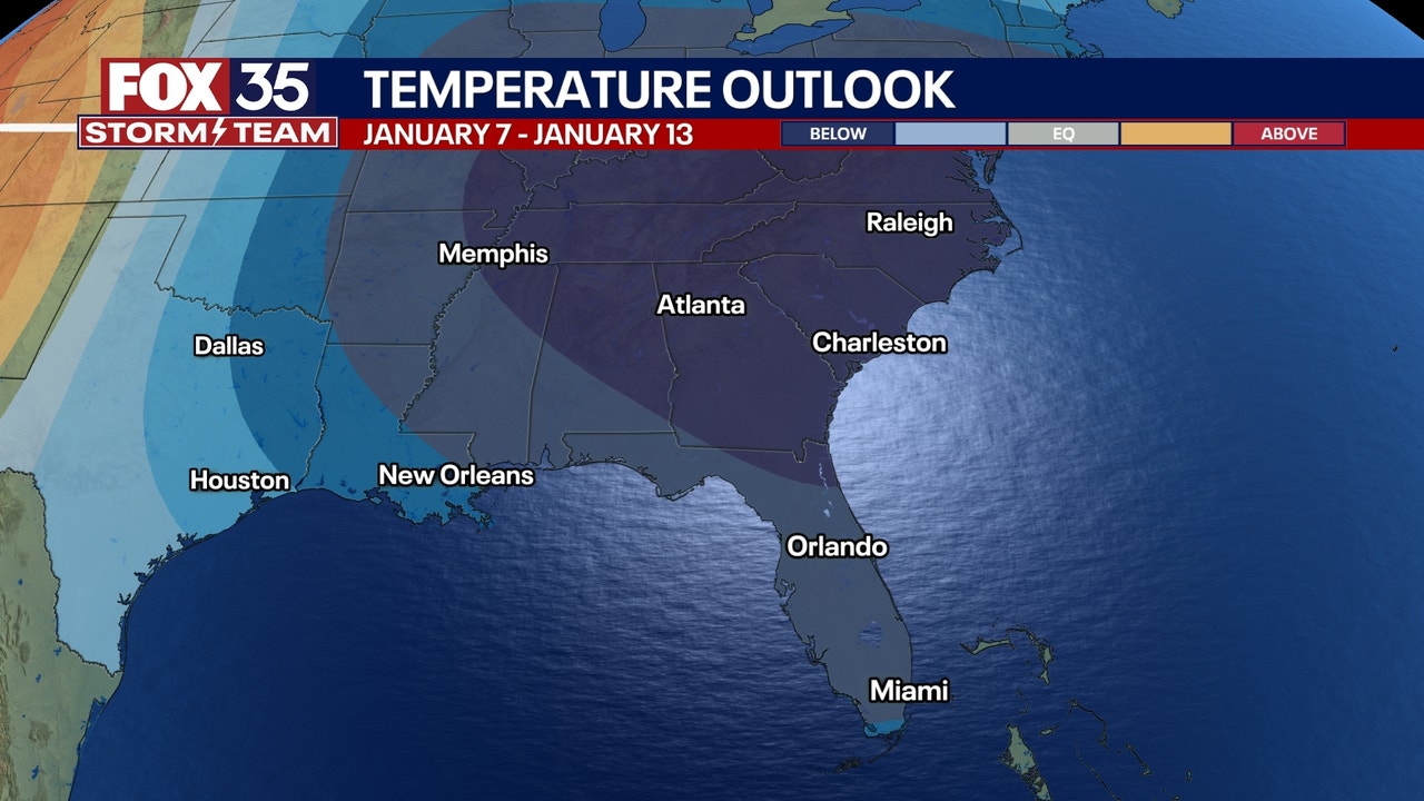
Orlando weather: Warm New Year’s Eve ahead of mid-week cooldown
Orlando Weather Forecast PM: Dec. 30, 2024
Florida drivers headed to work on Tuesday morning should use extra caution as dense fog may reduce visibilities across the region. A dense fog advisory has been issued for much of Central Florida – from Tampa on the west coast to Orlando to Cocoa Beach on the east coast – from 1 a.m. to 9 a.m. on Tuesday, according to the National Weather Service.
ORLANDO, Fla. – Expect partly cloudy skies overnight with areas of dense fog. Lows will range from the lower to middle 60s, with light winds from the southeast to southwest at 5 mph.
A Dense Fog Advisory remains in effect through Tuesday morning for much of Central Florida. Fog should lift by mid-morning, giving way to warm and breezy conditions with highs nearly 10 degrees above average. A few isolated showers are possible, with rain chances around 20%.


What is the New Year’s Eve forecast for Orlando?
The day will bring partly sunny skies with a slight chance of isolated showers. Highs will climb near 80, with breezy southwest winds at 10-15 mph. A cold front is expected to arrive near midnight, bringing a slight chance of sprinkles as temperatures settle into the mid-60s to welcome the new year.

What is the New Year’s Day forecast for Orlando?
New Year’s Day will usher in cooler weather, with highs in the upper 60s to lower 70s.
What is the weekend forecast for Orlando?
A secondary cold front on Friday will bring even chillier air, with Saturday’s highs only reaching the upper 50s to lower 60s. Overnight lows will dip into the upper 30s and lower 40s.
A brief warming trend will develop Sunday into the first week of 2025, with highs rebounding into the 70s before another stronger cold front approaches later in the week, potentially bringing colder air and scattered showers.
LOOKING AHEAD: By the weekend of the Disney Marathon on Jan. 12, we may see temperatures in the 20s for lows with 40s and 50s for highs. Here is a look at one of the projected cold temperature models for the week of Jan. 7.

Orlando 7-Day Weather Forecast

More radar maps from FOX 35 Storm Tracker Radar
Stay connected with FOX 35
Orlando Weather Update: Get ready for a warm New Year’s Eve before a mid-week cooldown!As we ring in the new year, Orlando is set to experience unseasonably warm temperatures on New Year’s Eve, with highs reaching the mid-80s. This means you can ditch the heavy coats and enjoy a balmy evening as you countdown to 2022.
However, don’t get too comfortable with the warm weather just yet. A mid-week cooldown is on the horizon, with temperatures expected to drop into the 60s by Wednesday. So make sure to take advantage of the warm weather while you can and soak up the sunshine before the cooler temperatures roll in.
Whether you’re planning on celebrating New Year’s Eve outdoors or just enjoying a leisurely day in the sun, be sure to stay updated on the latest weather forecasts to make the most of your time in Orlando. Here’s to a warm and wonderful start to the new year! #OrlandoWeather #NewYearsEve #WarmWeather #MidWeekCooldown
Tags:
Orlando weather, Warm New Year’s Eve, mid-week cooldown, Orlando weather forecast, Florida weather, New Year’s Eve weather, Orlando climate, temperature changes, seasonal weather, weather patterns, Orlando meteorology
#Orlando #weather #Warm #Years #Eve #ahead #midweek #cooldown


