Your cart is currently empty!
Tag: Tornado
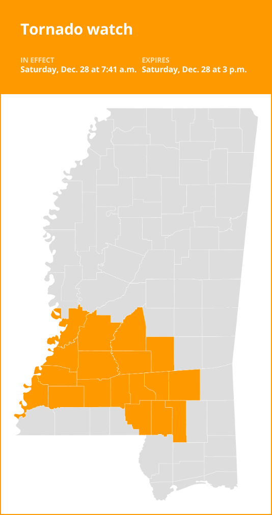
Southwest Mississippi under a tornado watch until Saturday afternoon
Southwest Mississippi under a tornado watch until Saturday afternoon
Published 7:47 am Saturday, December 28, 2024
On Saturday at 7:41 a.m. a tornado watch was issued by the National Weather Service in effect until 3 p.m. The watch is for Catahoula, Concordia, Franklin, Madison, Richland, Tensas, Adams, Claiborne, Copiah, Covington, Forrest, Hinds, Jefferson, Jefferson Davis, Jones, Lamar, Lawrence, Lincoln, Marion, Rankin, Simpson, Smith and Warren counties.

Tornado watch vs. Tornado warning: Know the difference
When it comes to tornadoes, understanding the distinction between a Tornado watch and a Tornado warning can be a matter of life and death. Here’s a breakdown:
Tornado watch: Be prepared!
- A Tornado watch is your advance warning that conditions are ripe for tornado formation.
- It’s your cue to review and discuss your emergency plans, check your supplies, and locate your safe room.
- While it doesn’t mean a tornado is imminent, it’s a heads-up that you should be ready to act quickly if a Tornado warning is issued or if you suspect a tornado is approaching.
- Watches come from the Storm Prediction Center and often cover a large area, potentially spanning multiple counties or even states.
Tornado warning: Take action!
- A Tornado warning signifies that a tornado has been spotted or detected by weather radar.
- This is the real deal – there’s an immediate threat to life and property.
- Your response should be swift: move to an interior room on the lowest floor of a sturdy building, away from windows.
- If you’re in a mobile home, a vehicle, or caught outdoors, seek the nearest substantial shelter and shield yourself from flying debris.
- Warnings are issued by your local forecast office and pinpoint a much smaller area, typically the size of a city or a small county, where a tornado has been identified, either by radar or by trained spotters and law enforcement.
Knowing the difference between these two alerts is essential in staying safe during tornado season. Stay informed, have a plan, and act promptly when danger approaches.
Prepare for a tornado
Stay weather-ready:
Check the forecast regularly to see if you’re at risk for tornadoes. Listen to local news or a NOAA Weather Radio to stay informed about tornado watches and warnings.
Sign up for alerts:
Familiarize yourself with your community’s warning systems. Some places have outdoor sirens, while others rely on media and smartphone alerts for severe storm notifications.
Create a communication plan:
Create a family emergency plan that includes a designated meeting place and important contact information. If your home lacks a basement, identify a nearby safe building, like a church or a relative’s house, that you can reach quickly.
Choose a secure shelter:
Pick a safe room in your home, such as a basement, storm cellar, or an interior room on the lowest floor with no windows.
Practice your plan:
Conduct a family severe thunderstorm drill regularly so everyone knows what to do if a tornado is approaching. Make sure all members of your family know to go there when tornado warnings are issued. Don’t forget pets if time allows.
Secure your home:
Consider reinforcing your safe room for added protection. You can find plans for fortifying an interior room on the Federal Emergency Management Agency website.
Help your neighbor:
Encourage your loved ones to prepare for the possibility of tornadoes. Take CPR training so you can help if someone is hurt.
Tornado safety: What to do when the twister hits
When a tornado strikes, taking swift action is crucial to ensuring your safety and minimizing potential harm. Follow these guidelines from the NWS:
Stay informed:
To ensure your safety during a tornado, remember that acting promptly is crucial, according to the NWS. Stay informed about tornado watches and warnings through regular updates on local news or a NOAA Weather Radio.
At home:
If you find yourself under a tornado warning while at home, head to your basement, a designated safe room, or an interior space away from windows. Ensure your pets are safe if time permits.
At work or school:
In the workplace or at school, adhere to tornado drill procedures and proceed promptly and calmly to your designated tornado shelter. Avoid areas with large, open spaces like cafeterias, gymnasiums, or auditoriums, and stay away from windows.
Outdoors:
If you’re outdoors and a tornado is approaching, seek immediate shelter inside a sturdy building. Sheds, storage facilities, mobile homes, and tents are not safe. If there’s time, make your way to a secure structure.
In a vehicle:
Being inside a vehicle during a tornado is highly unsafe. Your best course of action is to drive to the nearest shelter. If reaching shelter is not possible, either stay inside your car while covering your head, or abandon the vehicle and seek safety in a low-lying area such as a ditch or ravine.
Remember, acting swiftly and following safety protocols are essential for your well-being when a tornado is imminent.
Source: The National Weather Service
Attention Southwest Mississippi residents:
Please be aware that our area is currently under a tornado watch until Saturday afternoon. This means that conditions are favorable for the development of tornadoes, so it is important to stay informed and prepared.Make sure to keep a close eye on weather updates and warnings, and have a plan in place in case a tornado does strike. Stay tuned to local news and weather stations for the latest information.
Remember to seek shelter in a sturdy building, away from windows, if a tornado warning is issued. Do not wait until the last minute to take action – it is better to be safe than sorry.
Please take this threat seriously and stay safe during this time. Our thoughts are with all of those in the path of potential severe weather. Stay informed, stay prepared, and stay safe.
Tags:
- Southwest Mississippi
- Tornado watch
- Severe weather alert
- Mississippi weather
- Natural disasters
- Emergency preparedness
- Weather updates
- Tornado safety tips
- Mississippi tornado watch
- Southwest MS tornado warning
#Southwest #Mississippi #tornado #watch #Saturday #afternoon
Tornado watch vs. Tornado warning
New Orleans tornado threat: Knowing the difference between a Tornado Watch and Tornado Warning

Updated: 7:17 AM CST Dec 28, 2024
AND NOW IT’S TIME FOR ANOTHER CHECK ON OUR FIRST WARNING WEATHER. THIS IS A WEATHER ALERT DAY. DUE TO THE SEVERE STORMS WE ARE TRACKING FOR LATER TODAY. YEAH, LATER THIS AFTERNOON AND ESPECIALLY THIS EVENING, I THINK THAT’S WHEN THE WEATHER IS GOING TO BE THE WORST. AND IT LOOKS LIKE THESE STORMS COULD CONTAIN HEAVY RAIN. IT COULD RUN THE GAMUT, REALLY. TORNADOES ARE POSSIBLE. HAIL IN EXCESS OF AN INCH. WE’LL SHOW IT ALL TO YOU COMING UP IN JUST A MINUTE. BUT THE GOOD NEWS IS WE HAD A DENSE FOG ADVISORY IN EFFECT. NOT ANYMORE. IT’S BEEN CANCELED. WE’RE TRACKING A LITTLE BIT OF RAIN RIGHT NOW. AND A FEW THUNDERSTORMS ON WDSU. FIRST WARNING RADAR. RAIN AND THUNDERSTORMS THAT ARE MOVING TO THE NORTH NORTHEAST AT ABOUT 25MPH. BOGALUSA LOOKS LIKE THE RAIN GETTING HEAVIER FOR YOU IN THE NEXT TEN MINUTES. AND YES, THERE’S SOME THUNDER AND LIGHTNING THERE. THE UPPER RIGHT HAND SIDE OF YOUR SCREEN YOU CAN SEE THE LIGHTNING STRIKES IN THE LAST 15 MINUTES. RAIN MOVING RIGHT INTO THE HEART OF THE NEW ORLEANS AREA. NEW ORLEANS METAIRIE KENNER. WELL, LOOKS LIKE YOU MIGHT GET SOME LIGHT RAIN IN KENNER. HEAVIEST RAIN A LITTLE BIT FARTHER TO THE EAST OF YOU. HERE’S THE MOST ACTIVE THUNDERSTORM. PLAQUEMINES PARISH. NOW, THIS ISN’T A SEVERE THUNDERSTORM, BUT THERE IS SOME THUNDER AND LIGHTNING. I WENT TO VELOCITY MODE, AND I CHECKED TO SEE IF THERE WAS ANY ROTATION OR ANY STRONG WINDS WITH THIS CELL. NOT SO WITH THAT ONE. GOING TO BE A DIFFERENT STORY LATER ON TODAY. HERE’S YOUR VISIBILITY AS OF RIGHT NOW, ANYWHERE FROM 2 TO 10 MILES. AGAIN, THE NATIONAL WEATHER SERVICE HAS CANCELED THAT DENSE FOG. ADVISORY. 68 DEGREES. OUR TEMPERATURE WITH DEW POINT AT 68. SO THE HUMIDITY IS UP AT 100%, BUT AN EAST TO SOUTHEASTERLY WIND. I THINK KEEPING IT FROM BEING OVERLY FOGGY, WE’RE SEEING THE SHOWERS POP UP AHEAD OF AN AREA OF LOW PRESSURE AND A COLD FRONT. IT’S A COLD FRONT THAT WILL BE HERE PROBABLY LATE THIS EVENING, EARLY IN THE MORNING, AND THE FRONT REALLY ISN’T GOING TO BRING US A HUGE COOLDOWN, BUT IT IS GOING TO BRING US SOME DRIER AIR. AND YOU CAN SEE THAT THIS FRONT STILL IN TEXAS IS GOING TO MAKE STEADY PROGRESS OVER THE NEXT 12 TO 18 HOURS. NOW, THIS I ALWAYS WANT TO SAY SEVERE STORMS FORECAST CENTER, BECAUSE THAT’S WHAT THEY CALLED IT. WHEN I STARTED THIS BUSINESS, THE STORM PREDICTION CENTER ALWAYS ISSUES THIS MAP. THEY GO AHEAD AND LOOK AHEAD TOWARD THE NEXT 24 TO 48 AND 72 HOURS. OKAY. FOR PORTIONS OF THE NORTH SHORE, THERE IS AN ENHANCED RISK FOR SEVERE WEATHER TODAY. AS YOU GET FURTHER SOUTH, IT’S A SLIGHT RISK FOR SEVERE WEATHER. DON’T PAY ATTENTION TO THIS MAP TODAY BECAUSE ACROSS THE BOARD, WE HAVE TO BE READY FOR THE POSSIBILITY OF THUNDERSTORMS THAT MAY CONTAIN POSSIBLE TORNADOES, HAIL, GUSTY WINDS. THIS IS WHAT WE EXPECT LATE THIS AFTERNOON AND THIS EVENING. WIND GUSTS IN EXCESS OF 50MPH. TORNADOES ARE POSSIBLE AND THEY COULD BE SIGNIFICANT TORNADOES. WE COULD HAVE HAIL OVER AN INCH AND OVER TWO INCHES OF RAIN IS POSSIBLE. WORST WEATHER. PROBABLY GOING TO BE HERE TONIGHT. LET’S GO HOUR BY HOUR AND SHOW YOU HOW TODAY PLAYS OUT. SOME SCATTERED SHOWERS, MOST OF THEM ON THE LIGHTER SIDE THROUGH THE NOON HOUR. HERE WE ARE, PAUSING THINGS AT NOON. LET’S GO TO 3:00. CLOUDS PROBABLY GETTING A LITTLE BIT THICKER. STARTING TO SEE THE SHOWERS INCREASE A BIT, BUT RIGHT HERE. DINNERTIME, 6 P.M. THAT’S WHEN I THINK THE STRONG THUNDERSTORMS ARE GOING TO BE GETTING CLOSER TO US BY THE MID EVENING. 9:00 THERE YOU GO. THIS IS NOT GOING TO BE FUN. A GOOD EVENING TO STAY IN WATCH WDSU. WE HAVE METEOROLOGISTS ALREADY ON SCHEDULE. WE’RE ALWAYS GOING TO HAVE SOMEBODY IN THE BUILDING TRACKING THESE STORMS FOR YOU. MIDNIGHT. STILL SOME THUNDERSTORMS, POSSIBLY FOR THE SOUTH SHORE, BUT BY 3:00 IN THE MORNING WE START TO SEE THE SKIES CLEAR OUT JUST A LITTLE BIT. I THINK WE’RE GOING TO BE A TOUCH FOGGY IN A FEW LOCATIONS TOMORROW MORNING, BUT THE RAIN SHOULD BE DONE BY 6 A.M. AND BY THE LATER AFTERNOON, SKIES BEGINNING TO CLEAR. ACTUALLY, SUNDAY AFTERNOON SHOULD BE PRETTY PLEASANT, AND YOUR NEW YEAR’S EVE SHOULD BE PRETTY PLEASANT TOO. EVEN THOUGH I THINK WE’RE GOING TO HAVE A COLD FRONT MOVING THROUGH EARLY IN THE EVENING, NEW YEAR’S EVE TEMPERATURE, THOUGH, SHOULD BE IN THE 50S. DRY AND COOL BECAUSE IT’S GOING TO BE A DRY FRONT. SO HERE’S YOUR FORECAST FOR TODAY. INCREASING SHOWERS AND THUNDERSTORMS. THEY MAY BE STRONG, ESPECIALLY BY THE LATE AFTERNOON AND THE EVENING. THAT’S WHAT I’M CIRCLING 6 P.M. TO ABOUT MIDNIGHT. NUMEROUS SHOWERS AND THUNDERSTORMS IN THE FORECAST TONIGHT. SOME OF THEM, UNFORTUNATELY, MAY BE SEVERE, BUT THEN DECREASING CLOUDS BY SUNDAY AFTERNOON. AND WE SEE THAT COLD FRONT COMING THROUGH NEW YEAR’S EVE. SO HIGH TEMPERATURES ONLY IN THE 60S ON WEDNESDAY AND IN THE 50S FOR US THURSD
New Orleans tornado threat: Knowing the difference between a Tornado Watch and Tornado Warning
Updated: 7:17 AM CST Dec 28, 2024
Parts of Southeast Louisiana are under an enhanced risk for severe weather Saturday. The Northshore will see a potential threat of tornadoes. It is important to know the difference between a Tornado Watch and a Tornado Warning. The National Weather Service explains the difference between the two below: What is a Tornado Watch? Tornadoes are possible in and near the watch area. Review and discuss your emergency plans and check supplies and your safe room. Be ready to act quickly if a warning is issued or you suspect a tornado is approaching. Acting early helps to save lives! Watches are issued by the Storm Prediction Center for counties where tornadoes may occur. The watch area is typically large, covering numerous counties or even states.What is a Tornado Warning? A tornado has been sighted or indicated by weather radar. There is imminent danger to life and property. Move to an interior room on the lowest floor of a sturdy building. Avoid windows. If in a mobile home, a vehicle, or outdoors, move to the closest substantial shelter and protect yourself from flying debris. Warnings are issued by your local forecast office. Warnings typically encompass a much smaller area (around the size of a city or small county) that may be impacted by a tornado identified by a forecaster on radar or by a trained spotter/law enforcement officer who is watching the storm.
Parts of Southeast Louisiana are under an enhanced risk for severe weather Saturday.
The Northshore will see a potential threat of tornadoes.
It is important to know the difference between a Tornado Watch and a Tornado Warning.
The National Weather Service explains the difference between the two below:
What is a Tornado Watch?
Tornadoes are possible in and near the watch area. Review and discuss your emergency plans and check supplies and your safe room.
Be ready to act quickly if a warning is issued or you suspect a tornado is approaching.
Acting early helps to save lives! Watches are issued by the Storm Prediction Center for counties where tornadoes may occur.
The watch area is typically large, covering numerous counties or even states.
What is a Tornado Warning?
A tornado has been sighted or indicated by weather radar. There is imminent danger to life and property. Move to an interior room on the lowest floor of a sturdy building.
Avoid windows. If in a mobile home, a vehicle, or outdoors, move to the closest substantial shelter and protect yourself from flying debris.
Warnings are issued by your local forecast office. Warnings typically encompass a much smaller area (around the size of a city or small county) that may be impacted by a tornado identified by a forecaster on radar or by a trained spotter/law enforcement officer who is watching the storm.
A tornado watch and a tornado warning may sound similar, but they have very different meanings when it comes to severe weather.A tornado watch is issued by the National Weather Service when weather conditions are favorable for the development of tornadoes. This means that tornadoes are possible in and near the watch area. During a tornado watch, it is important to stay informed and be prepared to take action if a tornado warning is issued.
On the other hand, a tornado warning is issued when a tornado has been spotted on the ground or indicated by radar. This means that a tornado is imminent and poses a direct threat to life and property. When a tornado warning is issued, it is crucial to take immediate shelter and follow safety protocols to protect yourself and your loved ones.
In summary, a tornado watch means tornadoes are possible, while a tornado warning means a tornado has been detected and is heading towards your area. It is important to stay informed and prepared for severe weather events by monitoring weather alerts and having a plan in place.
Tags:
tornado watch, tornado warning, severe weather alert, difference between tornado watch and tornado warning, tornado safety tips, tornado preparedness, severe storm awareness, tornado risk assessment
#Tornado #watch #Tornado #warning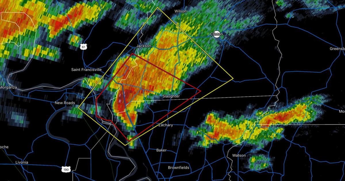
Tornado watches, warnings issued in Baton Rouge area | Weather/Traffic
Areas north of Baton Rouge were placed under a tornado warning on Saturday morning and a bigger swath of the state was placed under a tornado watch.
The National Weather Service issued the tornado watch around 7 a.m. for residents of West Feliciana and East Feliciana parishes. A storm just northwest of Zachary was moving northeast at 20 mph, the weather service said.
Meanwhile, much of Louisiana, from Baton Rouge to Shreveport, was placed under a tornado watch, lasting until 3 p.m. In addition to potential tornadoes, the Weather Service warned of hail and wind gusts of up to 70 miles per hour.
More than 4.9 million people live in the watch area, the weather service said.
Attention Baton Rouge residents, be aware that tornado watches and warnings have been issued in the area. It is important to stay informed and take necessary precautions to ensure your safety. Follow local weather updates and listen to any alerts or warnings from authorities. Stay indoors and away from windows during a tornado warning, and have a plan in place in case of severe weather. Stay safe and stay prepared. #BatonRouge #TornadoWarning #StaySafe
Tags:
- Tornado watches Baton Rouge
- Tornado warnings Baton Rouge
- Baton Rouge weather alerts
- Baton Rouge traffic updates
- Severe weather Baton Rouge
- Baton Rouge emergency alerts
- Baton Rouge tornado safety
- Baton Rouge storm updates
- Baton Rouge road closures
- Baton Rouge weather advisory
#Tornado #watches #warnings #issued #Baton #Rouge #area #WeatherTraffic
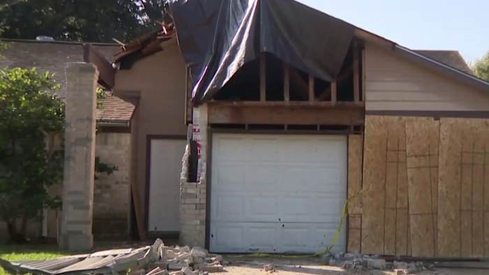
Single mom of six displaced after EF-1 tornado rips through SW Houston
HOUSTON – The National Weather Service confirms that an EF-1 tornado briefly touched down in Southwest Houston during a rash of tornadoes across Texas on Thursday.
A small, yet powerful tornado caused isolated damage to the Meadows Place neighborhood off of Kirkwood Road and Bissonnet Street.
According to a survey by the National Weather Service, wind speeds topped 90 miles per hour.
Several homes along Plumbrook Drive had damage, but one was severely damaged. The home belongs to Tanrita Johnson, a single mother of six.
Tanitra Johnson looks at damage to her home caused by an EF-1 tornado that touched down in Southwest Houston on December 26, 2024. (Copyright 2024 by KPRC Click2Houston – All rights reserved.) “To look at all the damage, the garage door was gone, windows missing, roof fell in. It’s kind of hard to look at,” she told KRPC 2′s Gage Goulding. “It could have been worse. Lives could have been lost.”
Johnson wasn’t home at the time the tornado touched down around 2:30 p.m. on Thursday. Actually, no one was home. Not even the family dog.
Tanitra Johnson: “It’s a blessing to still have my children.”
Gage Goulding: “Does that run through your mind all the what ifs? What could have happened?”
Tanitra Johnson: “Yes, because I was like, what if I was home? I probably would have tried to run out because the windows came in to see what was going on.”
Neighbor’s security cameras captured the tornado moving through the neighborhood.
A few doors down, a security camera captured the moment a USPS mail truck was overturned with the postal worker still inside.
Thankfully, the person was okay and able to climb out.
“The safety and well-being of our employees are of the utmost importance to the U.S. Postal Service,” said a USPS spokesperson. “In the case of the recent weather-related incident, which occurred on December 27, we can report that the USPS employee is safe and recovering. The postal vehicle was retrieved, secured, and taken to the local Post Office. Additionally, the mail was recovered immediately, and the Postal Service took steps to ensure prompt delivery of all items. We appreciate and value our dedicated employees. The USPS will continue to monitor weather conditions closely and implement measures to safeguard both our employees and the mail they handle.”
It’s that video and other tale tell signs that helped the National Weather Service figure out what happened here.
“There is some evidence of some twisting,” said Science and Operations Office at the National Weather Service, Lance Wood. “So, this really looks like a brief touchdown and then that’s it.”
Wood was working the radar on Thursday when the Natoinal Weather Service was issuing tornado warnings.
However, a small, quick, yet powerful tornado like this one can sometimes slip under the radar.
Gage Goulding: “Was this cell here warned or no?”
Lance Wood: “No. We put out a significant weather advisory because we knew we were watching it really closely, but there was no tornado warning for this particular cell. I think it just happened too fast.”
A volunteer with the American Red Cross Disaster Action Team surveys damage from an EF-1 tornado in Southwest Houston on December 27, 2024. (Copyright 2024 by KPRC Click2Houston – All rights reserved.) Happening just as fast is the new dilemma Tanitra is facing: where will she and her kids sleep tonight?
“I really do need help,” she said.
The American Red Cross was out surveying damage today to offer assistance. They honed in on her home, the most damaged of all.
“This is going to take a while to, you know, be finished,” Johnson said. “So, I have to do something.”
Copyright 2024 by KPRC Click2Houston – All rights reserved.
On April 7th, a powerful EF-1 tornado tore through Southwest Houston, leaving a trail of destruction in its wake. Among those affected is a single mother of six who has been left displaced and in need of assistance.The tornado ripped through the neighborhood, destroying homes and leaving many families without shelter. For this single mom, the devastation is particularly heartbreaking as she now has to find a way to provide for her children and rebuild their lives.
As the community comes together to support those impacted by the tornado, it is important to remember those who may be struggling the most, like this single mom. Donations of clothing, food, and other essential items can make a big difference in helping her and her children get back on their feet.
If you would like to help, please consider reaching out to local relief organizations or starting a fundraiser to support this family in their time of need. Together, we can make a difference and help this single mom and her children recover from this devastating event.
Tags:
- Single mom of six
- Displaced
- EF-1 tornado
- SW Houston
- Natural disaster
- Emergency assistance
- Family in crisis
- Community support
- Rebuilding after disaster
- Houston tornado relief
#Single #mom #displaced #EF1 #tornado #rips #Houston
Tornado touches down in southwest Houston, National Weather Service says
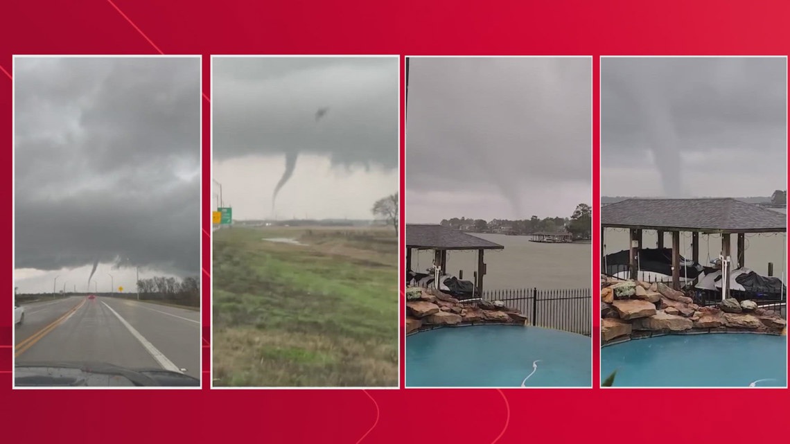
A strong line of storms moved through Southeast Texas on Thursday, sparking a slew of tornadoes throughout the afternoon.
HOUSTON — The National Weather Service on Friday confirmed that five tornadoes touched down in the Houston area a day after Christmas.
Those tornadoes were from a system that moved across the area, from Wharton County to Liberty County.
The NWS confirmed that an EF-1 tornado touched down in southwest Houston. They said the tornado caused some damage to homes as it came through with 90 mph winds. This tornado’s path was less than a tenth of a mile.
Later Friday afternoon, the NWS confirmed four more tornadoes.
- A tornado in El Campo was an EF-1 with 95 mph winds causing structural damage to a barn. Its path was a half a mile.
- An EF-0 tornado touched down in the north Liberty area with 76 mph winds causing structural damage to at least one home. Its path was nearly 7 miles long.
- Another EF-0 tornado touched down in the northwest Dayton area with 60 mph winds. Its path was 1.1 miles.
- Another EF-0 with 60 mph winds touched down in the Lake Houston/Huffman area. Its path was 2.1 miles.
More details on the tornadoes, including path widths and lengths, will likely be released in the coming days.


In Wharton County, where the first tornadoes were reported, the sheriff’s office said there were sightings at Loop 183 and County Road 428, FM 960 and FM 961 and in the area of Highway 59 and the El Campo truck stop heading northeast towards Pierce.
Later Thursday afternoon, there were sightings around Lake Houston and in the Atascocita area. In Liberty County, there were multiple reports of tornadoes as the storms moved out of the area.
When is Houston at risk for tornadoes?
In Houston, tornadoes can happen at any time of day, during any season, month or day of the year. Although the statistics show that they are more likely in late fall, winter and spring, there really is no “off-season” for severe weather and tornadoes in Houston.


Staying weather alert in Houston is a full-time job for all of us. This starts with knowing what the weather forecast is so you and your family don’t get caught off guard. Sign up for notifications on your phone. An old-school NOAA weather radio is a great way to always have the latest updates too. Make sure your family knows where to go to take shelter from an approaching storm, and where you’ll meet up afterward.
The Enhanced Fujita, or EF Scale classifies tornadoes into the following categories:
Tornado touches down in southwest Houston, National Weather Service saysThe National Weather Service has confirmed that a tornado touched down in southwest Houston earlier today. The tornado caused significant damage to homes and businesses in the area, with reports of downed power lines and debris scattered throughout the neighborhood.
Residents are urged to stay indoors and take shelter in the event of any additional severe weather. Emergency crews are currently on the scene assessing the damage and providing assistance to those in need.
Please stay tuned to local news outlets and the National Weather Service for updates on the situation. Our thoughts are with all those affected by this devastating tornado.
Tags:
- Tornado in southwest Houston
- National Weather Service report on tornado
- Houston tornado update
- Severe weather in Houston
- Southwest Houston tornado alert
- Tornado warning in Texas
- Houston weather emergency
- National Weather Service tornado advisory
- Houston tornado damage report
- Southwest Houston weather update
#Tornado #touches #southwest #Houston #National #Weather #Service
NWS confirms EF-1 tornado hit southwest Houston neighborhood where mail truck was knocked over
HOUSTON, Texas (KTRK) — The National Weather Service has confirmed that an E-F1 tornado hit Plumbrook Drive in southwest Houston the day after Christmas.
That tornado was on the ground for only a few seconds, and two homes were damaged.
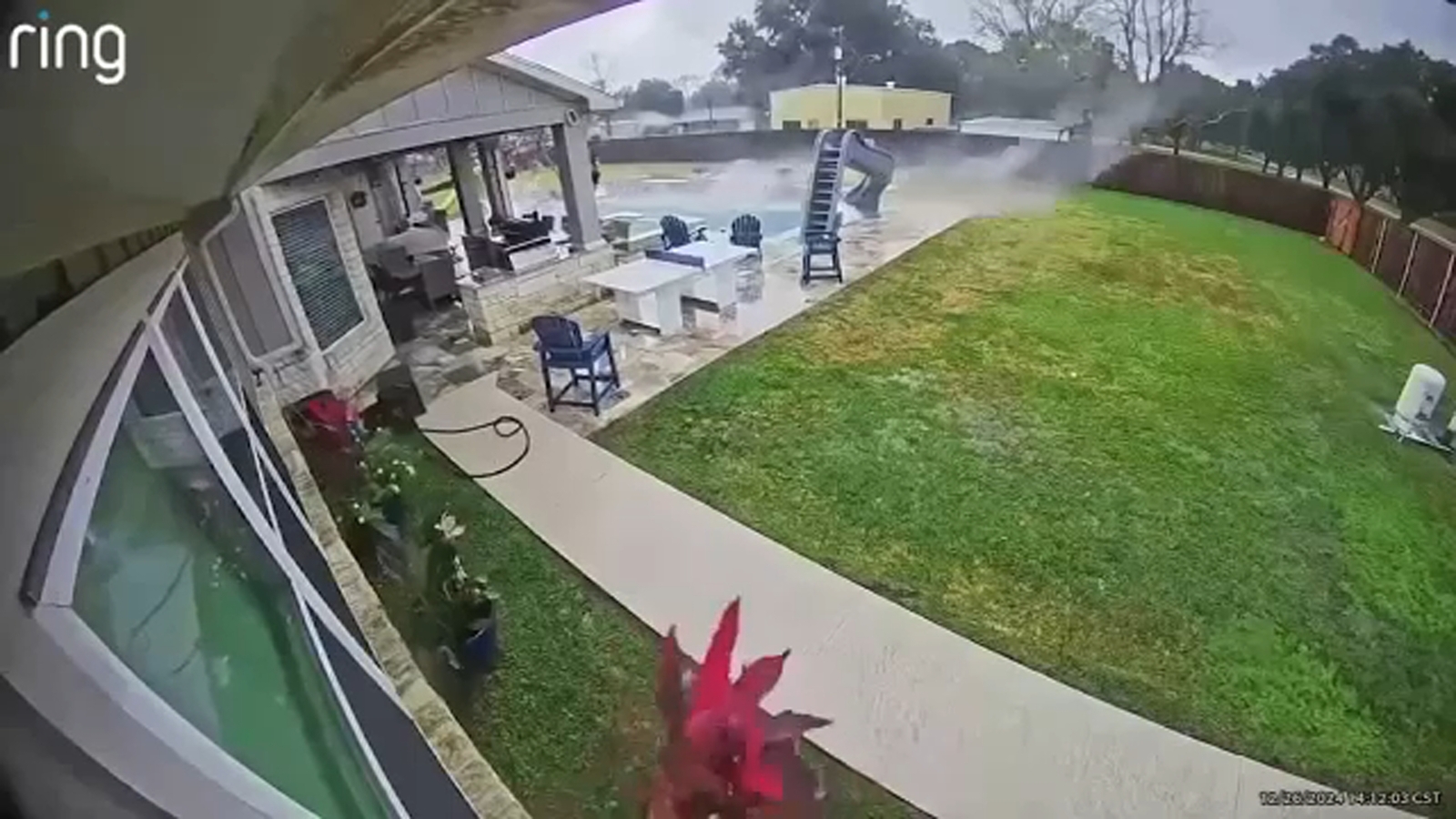
Footage from a camera in front of Frank Gongora’s home captures the moment heavy rain and strong winds pushed over a mailman’s vehicle, knocking it to the side.
Gongora was inside when it happened.
“I just heard very strong winds, and then I heard my wife scream and a loud crash, and I ran out to the living room,” Gongora said.
Another camera from his backyard shows a different angle – the fence rattling as the storm knocks over plants.
“I opened up the back door, and that’s when I saw the big old piece of steel and patio, and a portion of my fence was knocked over,” Gongora said.
Although his home is OK, that’s not the case for some of his neighbors. One home just a few doors down is the worst damage seen on that street. The right garage door has been ripped off, you can see through the attic, and the driveway is scattered with bricks.
A home across the street shows the garage door full of dents and shingles from the roof flew off.
Gongora has lived in this neighborhood since 2008 and has experienced natural disasters such as Hurricanes Ike, Harvey, and Beryl.
Gongora says Thursday was different.
“This one here was fast. I mean, not even a minute or two it seemed that way,” he said.
It’s not how this community wanted to end the year, but he and others are thankful no one was hurt.
“It makes you think, like, ‘What can happen tomorrow?’ Tomorrow is not promised,” Gongora said.
ABC13 spoke to residents in southwest Houston who are left cleaning up from Thursday’s storm.
Copyright © 2024 KTRK-TV. All Rights Reserved.
The National Weather Service has confirmed that an EF-1 tornado touched down in a southwest Houston neighborhood, causing significant damage and knocking over a mail truck. Residents in the area reported hearing a loud roar as the tornado swept through, uprooting trees and damaging homes.The powerful winds were strong enough to tip over a mail truck, highlighting the destructive force of the tornado. Thankfully, no injuries have been reported so far, but many residents are now left to clean up and assess the damage to their properties.
The NWS is continuing to investigate the tornado’s path and intensity, but residents are urged to stay alert and take precautions in case of any further severe weather. Our thoughts are with those affected by this natural disaster, and we hope for a swift recovery for the community.
Tags:
- NWS EF-1 tornado
- Southwest Houston tornado
- Mail truck knocked over
- Tornado damage Houston
- NWS storm confirmation
- Houston neighborhood tornado
- Extreme weather event
- Severe weather Houston
- Tornado aftermath
- NWS tornado report
#NWS #confirms #EF1 #tornado #hit #southwest #Houston #neighborhood #mail #truck #knocked
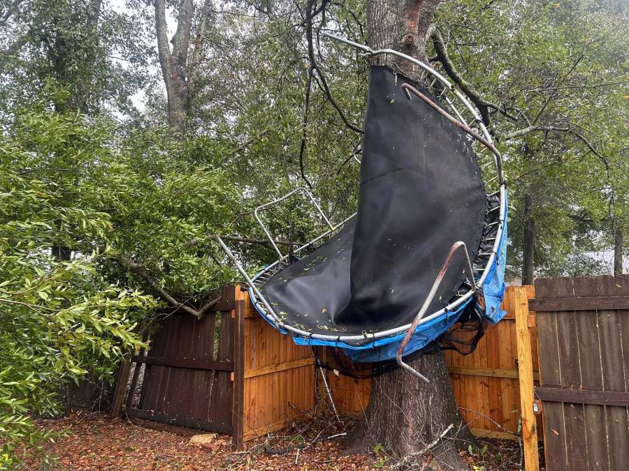
Damage reported in Mobile County after tornado warning (photos)
UPDATE (4:33 p.m.): News 5’s Asher Redd is in the Dawes community of Mobile County where a trampoline took flight during the tornado warning and more trees fell.
UPDATE (3:44 p.m.): News 5’s Asher Redd is at the intersection of Dawes Road and Southern Oaks Trail, where multiple trees are down.
UPDATE (3:34 p.m.): According to multiple Ring customers, Downtowner Boulevard and Montlimar Drive are flooded.
The National Weather Service has issued a flash flood warning through 6:15 p.m.
According to NWS, midtown Mobile, downtown Mobile, Prichard, I-10, I-65, Tacon, Mertz, Navco, Neshota, Forest Hill, West Hill, Wheelerville, Plateau and Dawes will be affected.
PREVIOUS REPORTING
MOBILE COUNTY, Ala. (WKRG) — WKRG is tracking reported damage across Mobile County after a tornado warning was in place from 2:05 p.m. through 2:45 p.m.
News 5 has received reports of multiple trees down on Grand Bay Wilmer Road near Leroy Hill Mansion.
There is also a signal outage at the intersection of Snow Road and Airport Boulevard.
In addition, Alabama Power has reported that hundreds of people in our coverage area are without power.
The First Alert Storm Team is reading your emails — please send storm damage information and photos to newsrelease@wkrg.com.
This is a developing story. News 5 will provide updates as more information becomes available.
Copyright 2024 Nexstar Media, Inc. All rights reserved. This material may not be published, broadcast, rewritten, or redistributed.
For the latest news, weather, sports, and streaming video, head to WKRG News 5.
On Wednesday evening, Mobile County residents were met with a tornado warning that caused widespread damage throughout the area. Several homes and businesses were destroyed, power lines were knocked down, and trees were uprooted.Local authorities have reported that there have been no injuries reported so far, but the extent of the damage is still being assessed. Emergency crews are on the scene to provide assistance and ensure the safety of residents.
Pictures from the affected areas show roofs torn off buildings, debris scattered across yards, and vehicles overturned. The community is coming together to help those affected by the storm, offering shelter, food, and support to those in need.
As the cleanup efforts continue, residents are urged to stay vigilant and heed any further warnings from local authorities. Our thoughts are with those impacted by this devastating storm, and we will continue to provide updates as more information becomes available. Stay safe, Mobile County.
#MobileCounty #TornadoWarning #DamageReported #StaySafeMobileCounty #CommunitySupport.
Tags:
- Mobile County tornado damage
- Severe weather in Mobile County
- Tornado warning aftermath in Mobile County
- Mobile County storm damage photos
- Mobile County tornado damage report
- Mobile County severe weather photos
- Tornado warning impact in Mobile County
- Mobile County tornado aftermath pictures
- Severe storm damage in Mobile County
- Mobile County tornado warning photos
#Damage #reported #Mobile #County #tornado #warning #photos
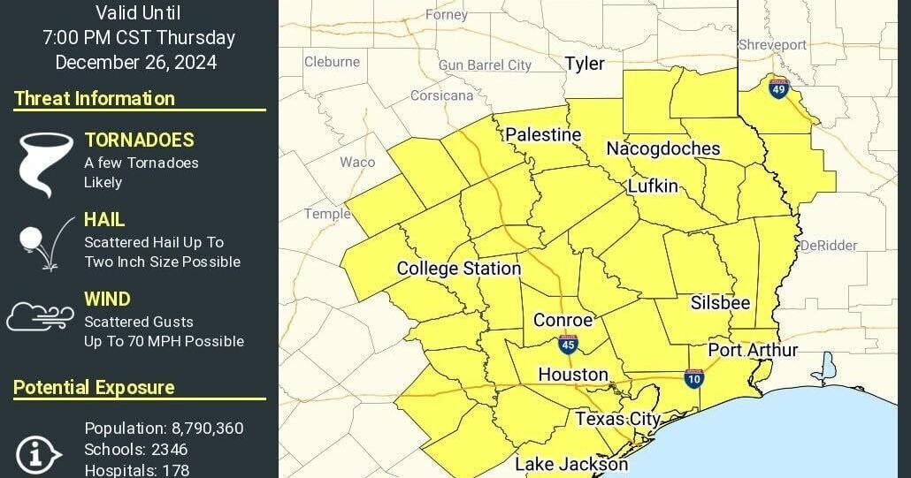
Tornado watch issued for Panola County through 7 p.m. Thursday | News
A tornado watch has been issued for parts of East Texas, including Panola County through 7 p.m. Thursday.
Threats include a few tornadoes, scattered hail up to 2-inch size and scattered wind gusts up to 70 mph, the National Weather Service said.
Texas counties included are Anderson, Angelina, Austin, Brazoria, Brazos, Burleson, Chambers, Cherokee, Colorado, Falls, Fort Bend, Freestone, Galveston, Grimes, Hardin, Harris, Houston, Jasper, Jefferson, Leon, Liberty, Limestone, Madison, Milam, Montgomery, Nacogdoches, Newton, Orange, Panola, Polk, Robertson, Rusk, Sabine, San Augustine, San Jacinto, Shelby, Trinity, Tyler, Walker, Waller, Washington and Wharton.
“A storm system moving across the region today will create an environment for severe thunderstorms areawide capable of producing tornadoes, large hail and heavy rainfall,” the NWS said. “The highest severe weather threat level remains in Deep East Texas due to the higher probability of tornadoes.”
Attention residents of Panola County: A tornado watch has been issued for our area through 7 p.m. Thursday. Please stay alert and be prepared to take shelter if necessary. Stay tuned to local news and weather updates for more information. Stay safe! #PanolaCounty #TornadoWatch #StaySafe
Tags:
- Tornado watch Panola County
- Severe weather warning Panola County
- Panola County tornado watch
- Tornado watch update
- Panola County weather alert
- Panola County emergency update
- Tornado watch Thursday
- Panola County safety alert
- Panola County news update
- Severe weather warning update
#Tornado #watch #issued #Panola #County #p.m #Thursday #News

Tornado watch issued for Rusk County through 7 p.m. Thursday | News
A tornado watch has been issued for parts of East Texas, including Rusk County through 7 p.m. Thursday.
Threats include a few tornadoes, scattered hail up to 2-inch size and scattered wind gusts up to 70 mph, the National Weather Service said.
Texas counties included are Anderson, Angelina, Austin, Brazoria, Brazos, Burleson, Chambers, Cherokee, Colorado, Falls, Fort Bend, Freestone, Galveston, Grimes, Hardin, Harris, Houston, Jasper, Jefferson, Leon, Liberty, Limestone, Madison, Milam, Montgomery, Nacogdoches, Newton, Orange, Panola, Polk, Robertson, Rusk, Sabine, San Augustine, San Jacinto, Shelby, Trinity, Tyler, Walker, Waller, Washington and Wharton.
“A storm system moving across the region today will create an environment for severe thunderstorms areawide capable of producing tornadoes, large hail and heavy rainfall,” the NWS said. “The highest severe weather threat level remains in Deep East Texas due to the higher probability of tornadoes.”
Attention all residents of Rusk County: A tornado watch has been issued for our area until 7 p.m. on Thursday. Please stay informed and be prepared to take action if necessary. Stay tuned to local news sources for updates and follow any instructions from emergency officials. Stay safe, everyone! #tornadowatch #RuskCounty #staysafe
Tags:
- Tornado watch
- Rusk County
- Severe weather alert
- Weather warning
- Emergency alert
- Tornado update
- Weather advisory
- Rusk County news
- Severe weather forecast
- Tornado safety tips
#Tornado #watch #issued #Rusk #County #p.m #Thursday #News
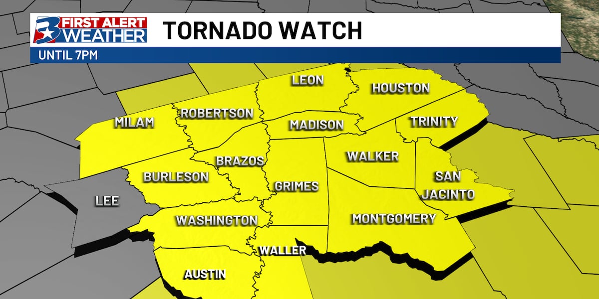
A Tornado Watch has been issued for the majority of the Brazos Valley
BRYAN, Texas (KBTX) – In anticipation of the development of rotating supercell thunderstorms, the National Weather Service has issued a Severe Thunderstorm Warning for the majority of southeast Texas until 7 pm.
The threat for tornadoes is expected to increase through the afternoon as the environment becomes more favorable for storm development. Increasing low-level storm relatively helicity and deep-layer shear will promote rotation in any strong storms that do get up and going, especially along and east of I-45.

All modes of severe weather are possible.(KBTX) All severe hazards will be possible for the Brazos Valley today. Have a plan in place and have multiple ways to receive weather alerts.
Copyright 2024 KBTX. All rights reserved.
Attention residents of the Brazos Valley: A tornado watch has been issued for the majority of our area. Please stay alert and be prepared to take action if necessary. Keep an eye on local weather updates and stay tuned to emergency alerts. Stay safe, everyone. #tornadowatch #BrazosValley #weatheralert
Tags:
tornado watch, Brazos Valley, severe weather, weather alert, tornado warning, emergency preparedness, storm safety, Texas weather, weather update
#Tornado #Watch #issued #majority #Brazos #Valley