HOUSTON, Texas (KTRK) — As residents in southeast Texas said goodbye to 2024, many communities dealt with the devastation of winter tornadoes.
In Alvin, Shane Colston was spending time with family and enjoying Christmas festivities when tornadoes hit his home.
“As soon as I came back inside, my wife saw something in the sky like debris flying around, and she asked me to look. As soon as I looked, I heard something in the glass,” Colston said.
His story is just one of many in southeast Texas. The National Weather Service says this past week and the last few years have been considered active for tornadoes.
“So we had about four different supercells that were producing tornadoes. Each one was producing several tornadoes, so I don’t know the exact amount. We’re still calculating that. But I’d say over half a dozen,” NWS Meteorologist Jeff Evans said.
While winter tornadoes are common, the NWS says that if they keep happening at the current rate, more needs to be done to prepare people for them.
“Obviously, if this pattern continues and this becomes our new norm, that’s a conversation we’re going to have to have as a community,” Evans said.
Eyewitness News asked if adding tornado sirens would help, which is something Shane would be on board with.
“That’s probably the best thing because you hear those go off, you know, something in your general area,” Colston said.
But NWS says cell phone notifications are more reliable.
“The thing about sirens is that they are mainly kind of outdoor sirens. You can’t guarantee that everyone is going to hear them inside the homes, especially in the middle of the night,” Colston said.
While many states prone to tornadoes use underground shelters, that would be a challenge in this area. However, there is another alternative.
“They do have tornado-safe rooms that you could put above ground as well. You can modify and put that into a home. If people are concerned, there are technologies out there that can give them a safer structure,” Evans said.
As winter approaches, the National Weather Service is urging residents in the Houston area to be more prepared for potential tornadoes. While Texas is typically known for severe weather during the spring and summer months, tornadoes can still occur in the winter.
Houston, in particular, has seen an increase in tornado activity in recent years, with several tornadoes touching down in the area last winter. The National Weather Service is recommending that residents have a plan in place in case of a tornado, including knowing where to seek shelter and having an emergency kit with essentials such as food, water, and medications.
In addition to being prepared at home, residents should stay informed about weather conditions by monitoring the National Weather Service’s forecasts and alerts. Tornadoes can develop quickly, so it is important to be proactive in staying safe.
By taking these precautions, residents can better protect themselves and their families in the event of a tornado. Let’s all work together to ensure the safety of our community during the winter months.
Tags:
texas tornadoes, houston area winter, national weather service, tornado preparedness, severe weather warning, texas weather updates, disaster preparedness, houston safety measures
New Orleans residents are on high alert this weekend as the city braces for potential tornadoes on Saturday. The National Weather Service has issued a tornado watch for the area, warning that severe weather conditions could develop throughout the day.
Meteorologists are closely monitoring a strong storm system that is expected to move through the region, bringing with it the possibility of damaging winds, hail, and tornadoes. The threat of tornadoes is particularly concerning, as these powerful storms can cause widespread destruction and pose a serious risk to life and property.
In response to the severe weather threat, city officials have activated the emergency alert system and are urging residents to stay informed and take precautions to ensure their safety. This includes staying indoors during the storm, securing loose objects outside, and having a plan in place in case of evacuation.
The potential for tornadoes in New Orleans is a stark reminder of the unpredictable and dangerous nature of severe weather. As climate change continues to impact our planet, extreme weather events are becoming more frequent and severe, underscoring the importance of being prepared and vigilant in the face of natural disasters.
In times like these, it is crucial for communities to come together and support one another. By staying informed, following safety guidelines, and looking out for our neighbors, we can weather the storm and emerge stronger on the other side.
As we await the arrival of this potentially dangerous weather system, let us all remain vigilant, stay safe, and keep our thoughts with those who may be impacted by the severe weather. Together, we can weather any storm that comes our way.
#Orleans #High #Alert #Potential #Tornadoes #Saturday,severe storms could bring a tornado risk to new orleans on saturday.
New Orleans residents are on high alert as the city prepares for potential tornadoes from Saturday storms. The National Weather Service has issued a tornado watch for the area, warning residents to be prepared for severe weather conditions.
The storms are expected to bring heavy rain, strong winds, and possibly even tornadoes to the New Orleans area. Residents are advised to stay indoors and seek shelter in a secure location if tornado warnings are issued.
In anticipation of the severe weather, the city has activated its emergency response plan and is working closely with local authorities to ensure the safety of its residents. The New Orleans Office of Homeland Security and Emergency Preparedness is urging residents to stay informed and follow all safety precautions.
Tornadoes can cause significant damage and pose a serious threat to life and property. It is important for residents to take all necessary precautions to protect themselves and their loved ones during severe weather events.
New Orleans has a history of dealing with severe weather, including hurricanes and tornadoes. The city is no stranger to the devastation that can be caused by these natural disasters, and residents are well aware of the importance of being prepared.
As the city braces for the potential tornadoes from Saturday storms, residents are urged to stay informed, stay safe, and take all necessary precautions to ensure their safety. By being prepared and staying vigilant, New Orleans residents can weather the storm and emerge unscathed.
#Orleans #Alert #Potential #Tornadoes #Saturday #Storms,severe storms could bring a tornado risk to new orleans on saturday.
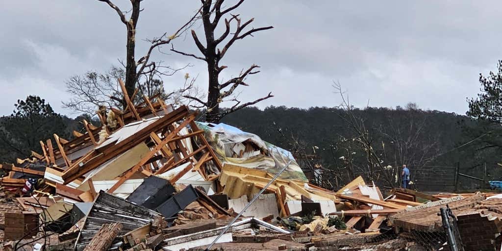
Yesterday, Alabama was hit hard by a series of powerful tornadoes and severe storms, leaving a path of destruction in their wake. The storms brought heavy rain, damaging winds, and hail, causing widespread damage to homes, businesses, and infrastructure.
The National Weather Service issued multiple tornado warnings throughout the day as the storms moved through the state, with reports of tornado touchdowns in several areas. Residents were urged to seek shelter and stay indoors as the dangerous weather passed through.
Emergency crews are now working tirelessly to assess the damage and provide assistance to those affected by the storms. Power outages have been reported in many areas, and road closures are in place due to debris and flooding.
Our thoughts are with the people of Alabama as they begin the process of recovery and rebuilding. It serves as a reminder of the power of nature and the importance of being prepared for severe weather events. Stay safe, Alabama.
One person is dead after a tornado ripped through Brazoria County, Texas, the Manvel mayor.
PORTER, Tex. — A deadly severe weather outbreak swept across the South Saturday evening, spawning multiple tornadoes across three states and leaving a trail of destruction in their wake.
One person died as one of those tornadoes swept through Texas’ Brazoria County, south of Houston, according to Manvel Mayor Dan Davis. Additional damage reports came in from Louisiana and Mississippi.
A three-hour radar loop. Warning boxes are color coded: Severe Thunderstorm Warnings are in yellow, Tornado Warnings are in red, Tornado Warnings with confirmed tornado are in purple, Flash Flood Warnings are in green and Flash Flood Emergencies are in pink. (FOX Weather)
A rare Particularly Dangerous Situation Tornado Watch was issued, and dozens of Tornado Warnings have wailed across the South into Saturday evening, with hours of dangerous weather still to go.
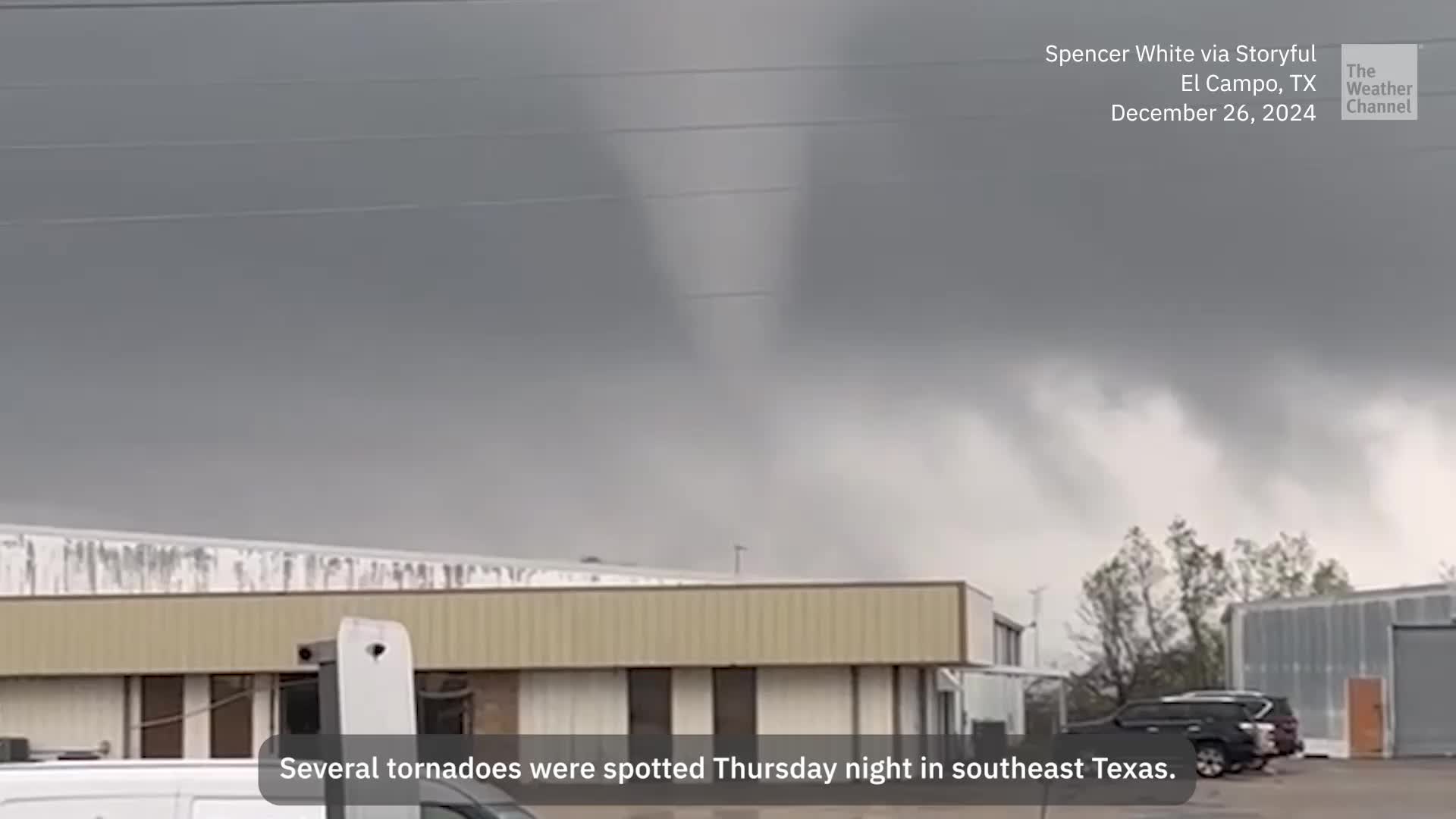
Multiple tornadoes cause damage near Houston on Saturday
Multiple tornadoes struck in southeastern Texas on the outskirts of Houston earlier in the day Saturday, causing significant damage to towns both north and south of the nation’s fourth-largest city.
Drone video showed several buildings suffering damage in Porter Heights north of Houston.
A tornado swept through the Porter Heights, Texas neighborhood on Dec. 28 leaving a trail of damage. (Video courtesy: Austin Clark Photography)
Spotters reported multiple mobile homes were hit, and the twister caused significant damage to a brick home and the East Montgomery Fire Department building, according to the National Weather Service office in Houston.
(Mark Keough Montgomery County Judge)
Tornado damage to the East Montgomery County Fire Department on Dec. 28, 2024. (Mark Keough Montgomery County Judge)
(Mark Keough Montgomery County Judge)
Tornado damage to the East Montgomery County Fire Department on Dec. 28, 2024. (Mark Keough Montgomery County Judge)
Tornado damage to the East Montgomery County Fire Department on Dec. 28, 2024. (Mark Keough Montgomery County Judge)
Tornado damage to the East Montgomery County Fire Department on Dec. 28, 2024. (Mark Keough Montgomery County Judge)
Tornado damage to the East Montgomery County Fire Department on Dec. 28, 2024. (Mark Keough Montgomery County Judge)
Tornado damage to the East Montgomery County Fire Department on Dec. 28, 2024. (Mark Keough Montgomery County Judge)
Tornado damage to the East Montgomery County Fire Department on Dec. 28, 2024. (Mark Keough Montgomery County Judge)
Tornado damage to the East Montgomery County Fire Department on Dec. 28, 2024. (Mark Keough Montgomery County Judge)
Reported tornado damage near Bude, Mississippi. (Corey Gerken)
Tornado damage is seen in this image of drone video taken above Porter Heights, Texas, on Dec. 28, 2024. (Austin Clark Photography/Facebook)
Storm damage is seen near Alvin, Texas, on Dec. 28, 2024. (Keith Brandt)
Storm damage is seen near Alvin, Texas, on Dec. 28, 2024. (Keith Brandt)
Reported tornado damage near Bude, Mississippi. (Corey Gerkin)
Reported tornado damage near Bude, Mississippi. (Corey Gerken)
Reported tornado damage near Bude, Mississippi. (Corey Gerken)
(Mark Keough Montgomery County Judge)
“There have been no reported injuries to our firehouse team at 154, and all pending calls have been cleared,” officials at the fire station wrote in a Facebook post.
In an update posted on Facebook, Montgomery County Judge Mark Keough said at least 15 people were trapped in homes after the storms, but they have been rescued.
FOX 26 Houston reporter Shelby Rose walked through one of the neighborhoods that suffered a direct strike from the tornado, finding some homes damaged or even destroyed.
FOX 26 Houston’s Shelby Rose reports from Porter, Texas where a tornado caused significant damage amid Saturday’s severe weather outbreak.
One family had nearly finished constructing a new home, but now it lay destroyed amid the tornadic ruins.
“This family was just about to move inside,” Rose said. “(The mother) is now in tears to see what once would have been her brand-new home, is now rubble.”
One killed in Brazoria County, Texas
Another report showed significant damage near the towns of Alvin and Liverpool, to the south of Houston.
FOX 36 Houston’s Jonathan Mejia reports from Liverpool, Texas where a tornado caused heavy damage amid a massive severe weather outbreak.
Multiple homes were destroyed, and substation debris was seen on State Highway 35.
Mayor Dan Davis of nearby Manvel said on X that he received confirmation that at least one person was killed by the storm as it tore through Brazoria County. He didn’t provide any further details about the death.
A family in nearby Liverpool had to scramble to take shelter as the tornado raced to their property.
Jose Ramirez told FOX 26 Houston reporter Jonathan Mejia he heard loud rain and thunder and ran back in to get his wife and dogs to run to a more sturdy shelter.
“When he came back out, he saw all this,” Mejia said, gesturing to the debris and damage scattered through the yard. “He tells me this was all reduced to nothing in a matter of seconds.”
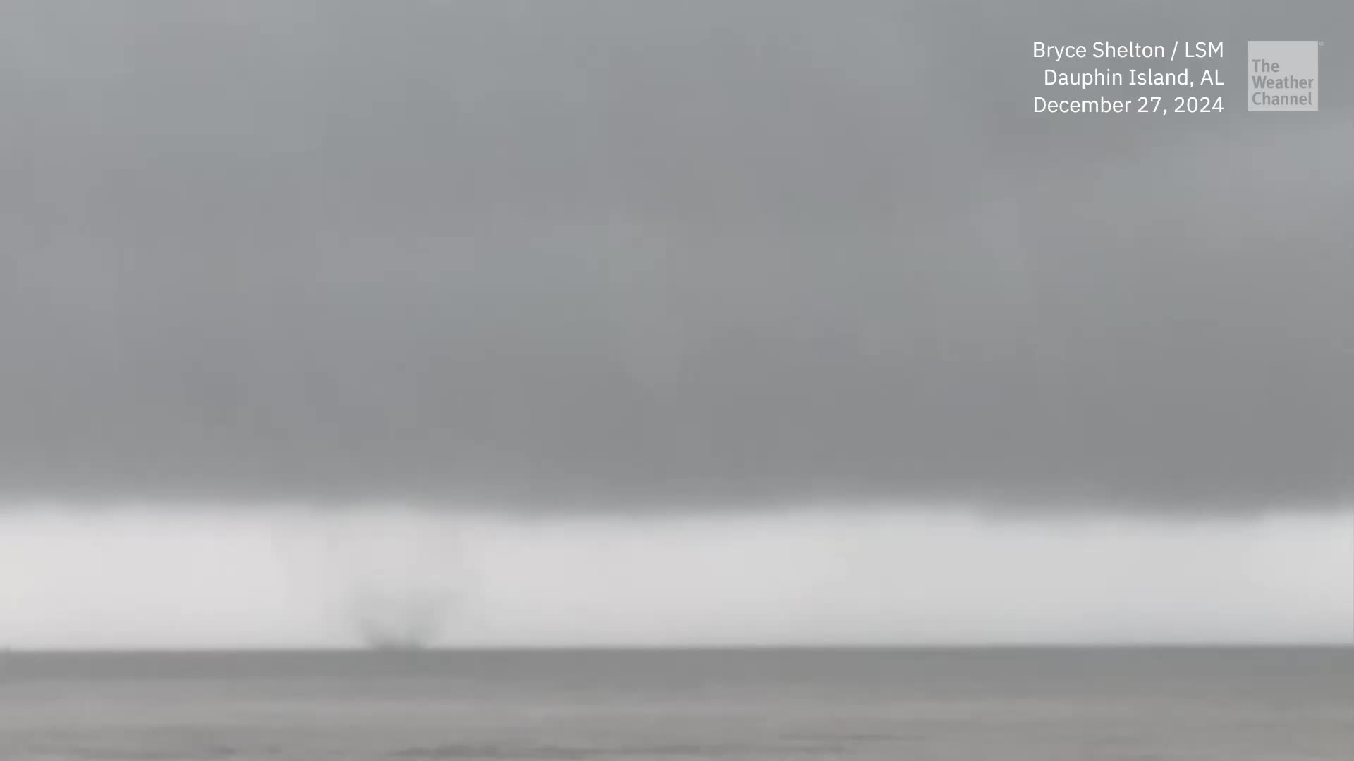
Video taken near the Houston suburb of Katy showed a funnel hovering above the ground earlier in the day. Spotters reported damage to a mobile home park near Noel Lane.
Debris can be seen swirling in the air in this video of a tornado that happened near Katy, Texas, on Saturday.
Trailers flipped in Mississippi as tornado swept through
More damage came in from southern Mississippi where a large tornado rolled through the town of Bude, tossing multiple trailer homes, according to FOX Weather Storm Trackers Corey Gerken and Brandon Copic.
A deadly severe weather outbreak is underway in the South. Tornado damage was reported near Bude, Mississippi, late Saturday evening.
“There were a couple mobile homes that literally were flipped — upended both ways,” Copic said. “And thankfully no injuries from what I saw. But there were injuries further down. A woman had minor injuries from my understanding. Thankfully, nothing catastrophic from what I’m being told.”
Port Arthur just missed a strong tornado
The tornado that swept near Liverpool would go on a more than four-hour, 120-mile journey along Texas’ Gulf Coast, tracking just north of Galveston and nearly making a direct hit on the town of Port Arthur.
The National Weather Service issued multiple Tornado Warnings on the twister, even denoting it as their more dire “particularly dangerous situation” type warning.
For several minutes, it appeared the heart of Port Arthur and its nearly 50,000 people would be in the crosshairs of the tornado, but luckily the storm veered just to the south, tracking over Sabine Lake instead.
“Overall, we have had minor property damage, downed power lines, and 2 reported minor injuries from debris,” Capt. Crystal Holmes of the Jefferson County Sheriff’s Office told FOX Weather. “One of our citizens homes was destroyed by the tornado.”
Severe weather threat moves east Sunday
The dangerous storms will march east by Sunday, with the worst weather expected in a swath that stretches from Virginia to Florida. Tornadoes, damaging wind and hail are possible with any severe storms that develop in this zone.
The severe weather outlook for Dec. 29, 2024. (FOX Weather)
Deadly severe weather outbreak ongoing as tornadoes rip through South
The South is currently facing a devastating severe weather outbreak as tornadoes tear through multiple states, leaving a trail of destruction in their wake. Reports of widespread damage and casualties are coming in as residents hunker down and brace for more potentially deadly storms.
Emergency services are working around the clock to rescue those trapped in the rubble and provide aid to those affected by the severe weather. The National Weather Service has issued numerous tornado warnings and watches, urging residents to seek shelter and stay safe.
As the situation continues to unfold, it is crucial for everyone in the affected areas to stay informed and follow the instructions of local authorities. Our thoughts are with those impacted by this deadly outbreak, and we urge everyone to stay safe and vigilant during this dangerous time.
Residents across Southeast Texas are being urged to take cover as multiple tornadoes have been spotted in the area. The National Weather Service has issued tornado warnings for several counties, including Harris, Montgomery, and Fort Bend.
These tornadoes are part of a severe weather system that is moving through the region, bringing with it strong winds and heavy rain. Residents are advised to seek shelter in a sturdy building and stay away from windows.
Emergency services are on high alert and are ready to respond to any reports of damage or injuries. It is important to stay informed and follow the guidance of local authorities during this dangerous weather event.
Please stay safe and take all necessary precautions to protect yourself and your loved ones from these dangerous tornadoes.
Severe storms are possible in the New Orleans weather forecast through Saturday
Threats of heavy rain, lightning, strong winds, large hail, and tornadoes are possible
Updated: 10:28 PM CST Dec 27, 2024
REMAINS LOW. WDSU FIRST WARNING WEATHER IMPACT DAY FOR FOG RIGHT NOW. AN ALERT DAY TOMORROW FOR THE THREAT FOR SEVERE STORMS. SHOULD BE ABLE TO SEE THE CRESCENT CITY CONNECTION BEHIND ME, BUT THAT’S THAT’S GOING TO BE OBSCURED FROM THE FOG. HERE ARE THE VISIBILITY REPORTS. LESS THAN A 10TH OF A MILE AT THE AIRPORT RIGHT NOW. I WAS JUST CHECKING OUT SOME ARRIVALS AT MSI AT LOUIS ARMSTRONG INTERNATIONAL, AND THERE HAVE BEEN SOME DELAYS. I’VE SEEN SOME THAT WERE SET FOR A LITTLE BIT LATER. THIS COULD BE FROM OTHER AIRPORTS COMING IN, BUT WHEN YOU’VE GOT VISIBILITY THAT IS OBSCURED, YOU’RE NOT GOING TO BE ABLE TO LAND PLANES IN THAT. SO I WANT YOU TO BE AWARE IF YOU’VE GOT LATE FLIGHTS COMING IN, IF YOU’RE TRYING TO TAKE OFF DOWN TO A MILE VISIBILITY IN THE HAMMOND, HALF A MILE INTO HOUMA, DENSE FOG ADVISORY IS ALREADY IN PLACE, AND THAT DENSE FOG ADVISORY WILL GO UNTIL 10 A.M. TOMORROW MORNING. IT INCLUDES THE LAKES, TOO. THEY’RE JUST NOT SHOWN IN SOME OF THE OUTER WATERS HERE AS WELL. WE STILL HAVE SOME STORM ACTIVITY TO TALK ABOUT, THOUGH. AT THIS TIME OF NIGHT. THIS IS SOMETHING THE FORECAST DATA HAVEN’T REALLY PICKED UP ON, BUT LOWER PLAQUEMINES TO NAIRN VENICE MARINA BOOTHVILLE GETTING SOME HEFTY STORMS. ONE STORM THAT MOVED ON SHORE THAT WAS SOUTHWEST OF HOUMA. THAT’S NOT DOING MUCH HERE. WE LOOK AT WHAT’S UP FOR THE STRONGEST STORMS. YOU CAN SEE AS YOU GO TO OUTER SAINT BERNARD PARISH AND MORE SOME RURAL AREAS. BUT THERE IT IS AS WE HEAD TOWARDS THE SMALLER COMMUNITIES TO PORT SULFUR, GRAND BAYOU, NAIRN, EMPIRE, VENICE, DE BURAS GETTING SOME OF THAT HEFTY STORM. AND THAT’S WHERE THE WORST OF THEM ARE. TONIGHT, WHEN I WAS JUST SAYING OUR FORECAST DATA, WE’RE NOT PICKING UP ON THIS STORM ACTIVITY. BUT LATELY THEY STARTED TO CHIME IN ONTO IT AND SHOW THAT THIS STORM ACTIVITY DOES THE SOUTHWEST TO NORTHEAST MOVEMENT AND STAYS MORE EAST OF NEW ORLEANS. WE WILL GO FROM THERE. IN THIS PARTICULAR FORECAST. SO WHERE WE STAND WITH MILD WEATHER IN PLACE AND THOSE TEMPERATURES VERY CLOSE TO THE DEW POINTS HERE TO WE’RE 60S OR 70S STILL 71 AT THE AIRPORT, 69 LAKEFRONT AND THOSE ARE ALMOST EXACTLY WHERE THE DEW POINT TEMPERATURES ARE. SO WE’VE FORMED CLOUDS AND WE’VE PUT IT ON THE GROUND AND THAT’S FOG. SO WHERE DO WE STAND IN THE WAY OF STORM SYSTEMS? AND WHAT BRINGS THIS RISK FOR POSSIBLE SEVERE WEATHER INTO THE ALERT DAY TOMORROW? WELL, THIS STORM IS MOVING AWAY. IT’S INTO THE UPPER MIDWEST. BUT THIS STORM REALLY MOVES QUICKLY AND IT TAPS INTO THE HEAT AND HUMIDITY. WE’VE GOT STRONG WINDS ALOFT THAT ARE COMING UP AT ABOUT 30,000FT TO ADD MORE LIFT, MORE ENERGY TO THE ATMOSPHERE. AND THAT AREA OF LOW PRESSURE TO BEING SO CLOSE TO US PROVIDES SOME OF THAT WORST SPIN AT GROUND LEVEL. SO WE DO HAVE AN ELEVATED TORNADO RISK HERE TOO. SO LET’S JUMP RIGHT INTO THE FORECAST. I WANT TO GIVE YOU THE TIMING AND EXACTLY WHAT THE THREATS WILL BE FOR YOU. LATEST SHORT TERM DATA. THIS ONE LINES UP PRETTY WELL TO SHOW, AS I JUST DESCRIBED, SOUTHWEST NORTHEASTWARD MOVEMENT. BUT MAYBE SOME MORNING STORMS START TO FIRE AS SOON AS WE’RE GETTING TO SUNRISE. BUT THE FOG WILL OBSCURE THAT AS EVERYBODY HAS SEEN THAT FOG START TO FORM AND JUST CONFIRM WITH THE DATA THAT WE’VE GOT THICK AND DENSE FOG ALL NIGHT TONIGHT. BE REALLY, REALLY CAREFUL. THE CAUSEWAY TWIN SPANS. IT LOOKS TO BE THE BONNIE. KERRY IS THE WORST OF IT RIGHT NOW. 60S TO START OFF TOMORROW MORNING. AND THE LEVEL THREE RISK FOR PARTS OF THE NORTH SHORE. LEVEL TWO AND A LEVEL ONE RISK FOR SEVERE WEATHER THREATS. WE CALL THOSE ENHANCED SLIGHT AND MARGINAL. WHAT DOES THIS REALLY MEAN. THOSE ARE ELEVATED RISKS FOR POSSIBLE SEVERE STORMS, WHICH IS WHY WE’VE ALREADY MADE IT AN ALERT DAY. HERE’S THE STORM POTENTIAL. SOME MORNING STORMS HERE, BUT THEY’RE NOT EXPECTED TO BE ALL THAT STRONG BY ABOUT 2:00 IN THE NORTH SHORE. WE DO SEE A FEW STRONGER STORMS TRYING TO POP UP AND GET GOING. BUT AFTER 6 P.M., THE MAIN ROUND OF STORMS COMING IN NORTH SHORE RIVER PARISHES FIRST, AND THEN AS WE GET 8 TO 10:00, WE SEE THOSE STORMS COMING IN NEW ORLEANS. HEFTY STORMS AROUND PONCHATOULA TO HAMMOND, EVEN MAYBE CAREER IN POPLARVILLE. AND THEN AS WE GO TO THE EARLY MORNING HOURS, THE STORMS ARE FINALLY STARTING TO GO AWAY. SO THE TIMING FOR MOST OF US AFTER 6 P.M. TOMORROW, THAT’S WHERE THE WORST OF THE STORMS COULD BE HERE, STILL WITH VERY HEAVY RAIN ONE, TWO AND THREE INCHES POSSIBLE. IT IS WARM AND HUMID AND BREEZY HERE TOO, ADDING THE ENERGY TO THE ATMOSPHERE SO HEAVY RAIN AND STRONG WIND GUSTS POTENTIAL TOP MY THREAT LIST. WE EVEN HAVE LARGE HAIL POTENTIAL OF THE SIZE OF ONE INCH OR LARGER, BUT THE TORNADO THREAT IS STILL ELEVATED. IT’S NOT AT A HIGH THREAT, BUT IT IS STILL THERE. SO THE NORTH SHORE REALLY NEEDS TO BE ON GUARD. REALLY WATCH THE ELEVATED TORNADO RISK IN NUMEROUS STRONG STORMS. BESIDES, THE TORNADO RISK ARE EXPECTED TO, WHICH IS WHY IT’S THE WDSU FIRST WARNING WEATHER ALERT DAY. METEOROLOGIST JIM STEIN COMING IN. I’LL GIVE HIM A HAND. METEOROLOGIST RAVEN RICHARD JOINS IN THE AFTERNOON EVENING. ONCE THEY’RE DONE ON SATURDAY. THE STORMS, THAT IS. WE’RE DOWN TO 72 FOR SAINT SUNDAY AND LESS HUMID. SHOU
Severe storms are possible in the New Orleans weather forecast through Saturday
Threats of heavy rain, lightning, strong winds, large hail, and tornadoes are possible
Updated: 10:28 PM CST Dec 27, 2024
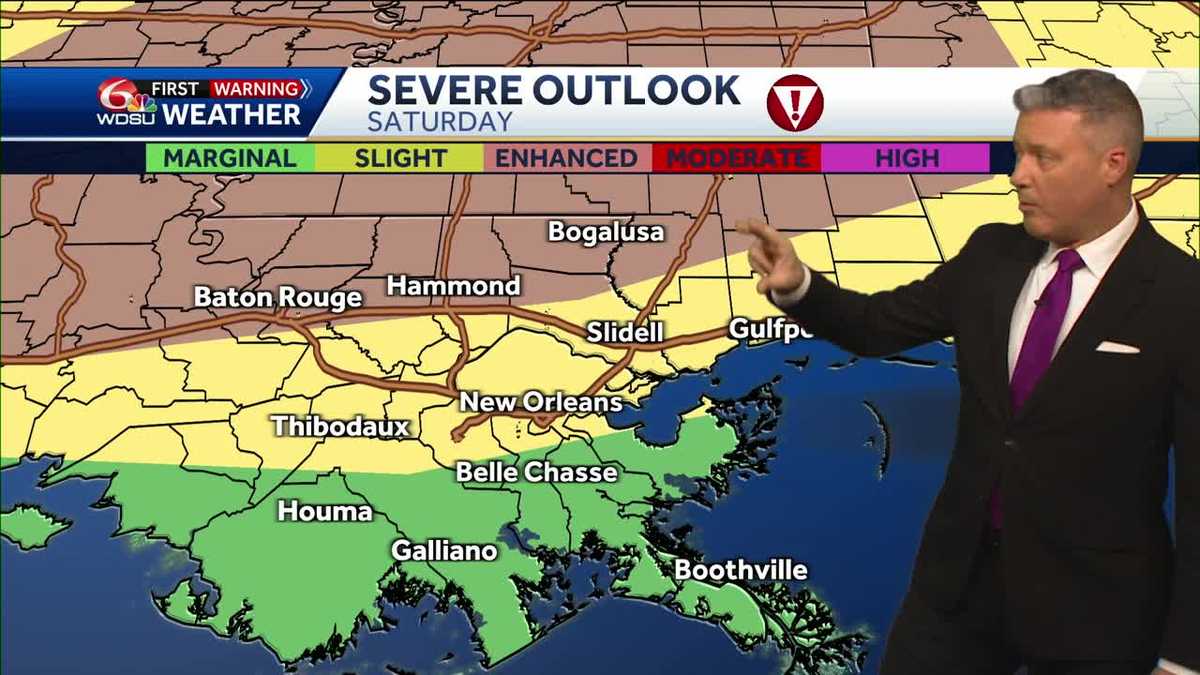
The Storm Prediction Center (SPC) has issued a severe weather outlook for portions of our area on Saturday. The WDSU First Warning Weather Team has identified Saturday as a Weather ALERT Day for the threat of severe storms.One round of severe storms passed through early Friday morning, including a confirmed tornado in St. Tammany Parish between Audubon and Talisheek. Saturday will be our likeliest chance of possible severe weather where parts of the Northshore are already under a level 3 out of 5, or Enhanced risk for severe storms with threats of severe winds over 58 mph, large hail of 1″ in size or larger, and possible tornadoes.Notice that Greater New Orleans is under a level 2 out of 5 categories, or Slight Risk for possible severe weather, while the coast is under a level 1, marginal risk for severe storms.In these scenarios, most of the worst of the severe weather should stay well north of us in Northern Louisiana and Mississippi. However, the Northshore is where storms are likely to fire up first, then track into Mississippi providing a brief window where storms could quickly reach severe limits possibly producing a tornado or two.The latest data show it’s after 6 PM where the main cluster of storms will enter the Northshore and pose the greatest risk of severe weather.These storms are forecast to move southeast and could impact the New Orleans metro late Saturday night.The greatest risk for severe weather will be locally heavy rain, followed by strong winds over 58 mph, then large hail 1″ in size or larger, and a few tornadoes.The biggest takeaways are knowing the Northshore has the highest chance for severe weather on Saturday. I do expect numerous strong to severe storms and the tornado risk is elevated for us.Right now, it looks like most of the South Shore south of I-10 is under the least threat from strong to severe storms. However, everyone needs to monitor this evolving forecast closely in case location and timing of storms change.
The Storm Prediction Center (SPC) has issued a severe weather outlook for portions of our area on Saturday. The WDSU First Warning Weather Team has identified Saturday as a Weather ALERT Dayfor the threat of severe storms.
One round of severe storms passed through early Friday morning, including a confirmed tornado in St. Tammany Parish between Audubon and Talisheek.
Saturday will be our likeliest chance of possible severe weather where parts of the Northshore are already under a level 3 out of 5, or Enhanced risk for severe storms with threats of severe winds over 58 mph, large hail of 1″ in size or larger, and possible tornadoes.
Notice that Greater New Orleans is under a level 2 out of 5 categories, or Slight Risk for possible severe weather, while the coast is under a level 1, marginal risk for severe storms.
In these scenarios, most of the worst of the severe weather should stay well north of us in Northern Louisiana and Mississippi. However, the Northshore is where storms are likely to fire up first, then track into Mississippi providing a brief window where storms could quickly reach severe limits possibly producing a tornado or two.
The latest data show it’s after 6 PM where the main cluster of storms will enter the Northshore and pose the greatest risk of severe weather.
These storms are forecast to move southeast and could impact the New Orleans metro late Saturday night.
The greatest risk for severe weather will be locally heavy rain, followed by strong winds over 58 mph, then large hail 1″ in size or larger, and a few tornadoes.
The biggest takeaways are knowing the Northshore has the highest chance for severe weather on Saturday. I do expect numerous strong to severe storms and the tornado risk is elevated for us.
Right now, it looks like most of the South Shore south of I-10 is under the least threat from strong to severe storms. However, everyone needs to monitor this evolving forecast closely in case location and timing of storms change.
Stay informed and stay safe, New Orleans! The weather forecast for the upcoming days includes a chance of severe weather, with the possibility of tornadoes. Make sure to stay updated on the latest weather alerts and warnings, and have a plan in place in case of an emergency. Stay tuned to local news sources and weather updates to stay informed. Remember, it’s always better to be prepared and stay safe during severe weather events. #NewOrleansWeather #SevereWeather #TornadoWatch
When natural disasters strike, the impact can be devastating, leaving communities in need of immediate relief aid and support. In times of crisis, it is crucial to have a plan in place for emergency preparedness, survival, and recovery.
In this ultimate guide, we will discuss how to navigate financial aid and recovery resources for various natural disasters such as hurricanes, earthquakes, floods, tornadoes, and more. From securing emergency funds to rebuilding your community, we will cover everything you need to know to weather the storm and come out stronger on the other side.
1. Emergency Preparedness: The first step in navigating natural disaster relief aid is to have a solid emergency preparedness plan in place. This includes creating an emergency kit, establishing a communication plan with loved ones, and knowing your evacuation routes. By being prepared, you can minimize the impact of a disaster and ensure the safety of yourself and your community.
2. Financial Aid: In the aftermath of a natural disaster, financial aid can be crucial for rebuilding and recovery. There are various sources of financial aid available, including government assistance, nonprofit organizations, and insurance policies. It is important to research and apply for all available resources to ensure you have the support you need to recover.
3. Community Resilience: Building community resilience is essential for long-term recovery and sustainability. By coming together and supporting one another, communities can bounce back stronger after a disaster. This includes organizing volunteer efforts, supporting local businesses, and advocating for policies that promote disaster preparedness and resilience.
4. Survival Tips: During a natural disaster, it is important to prioritize your safety and well-being. This includes staying informed about the latest updates and warnings, following evacuation orders, and seeking shelter in a safe location. By staying calm and following safety guidelines, you can increase your chances of survival during a disaster.
5. Recovery Efforts: After a natural disaster, recovery efforts can be a long and challenging process. It is important to have a clear plan for rebuilding your home, community, and life. This may involve working with contractors, applying for grants and loans, and seeking emotional support for trauma and loss. By staying focused and resilient, you can overcome the challenges of recovery and move forward with hope and strength.
In conclusion, navigating natural disaster relief aid requires careful planning, resilience, and community support. By following the tips and resources outlined in this guide, you can be better prepared to weather the storm and rebuild stronger than ever before. Remember, you are not alone – together, we can overcome any challenge and emerge stronger on the other side.
#Natural #Disaster #Relief #Aid #Navigating #Financial #Aid #Recovery #Ultimate #Guide #Emergency #Preparedness #Survival #Community #Resilience #Hurricanes #Earthquakes #Floods #Tornadoes, Disaster Recovery